Dewey, Montana | |
|---|---|
 Dewey  Dewey | |
| Coordinates: 45°46′35″N112°51′19″W / 45.77639°N 112.85528°W | |
| Country | |
| State | |
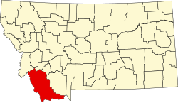
| County | Beaverhead |
| Area | |
• Total | 0.27 sq mi (0.69 km2) |
| • Land | 0.26 sq mi (0.68 km2) |
| • Water | 0.00 sq mi (0.01 km2) |
| Elevation | 5,515 ft (1,681 m) |
| Population (2020) | |
• Total | 25 |
| • Density | 94.70/sq mi (36.62/km2) |
| Time zone | UTC-7 (Mountain (MST)) |
| • Summer (DST) | UTC-6 (MDT) |
| ZIP Code | 59727 (Divide) |
| Area code | 406 |
| FIPS code | 30-20725 |
| GNIS feature ID | 2804244 [2] |
Dewey is an unincorporated community and census-designated place (CDP) in Beaverhead County, Montana, United States. It is in the northeast part of the county, on the south side of the Big Hole River, and bordered to the north, across the river, by Silver Bow County. Montana Highway 43 passes through Dewey, leading east 7 miles (11 km) to Interstate 15 at Divide, and west up the Big Hole River valley 5.5 miles (8.9 km) to Wise River and 44 miles (71 km) to Wisdom.
Dewey was first listed as a CDP prior to the 2020 census. [2]