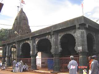
Bhimashankar Temple is a Jyotirlinga shrine located 50 km Khed taluka, near Pune, in Maharashtra, India. It is located 127 km from Shivajinagar in the Ghat region of the Sahyadri Mountains. Bhīmāshankar is also the source of the river Bhima, which flows southeast and merges with the Krishna river near Raichur.
Malshiras is a town and the headquarters of Malshiras taluka in Solapur district of Maharashtra state in western India. Its governing body is promoted to Nagar Panchayat from a Gram Panchayat in 2017. There are many popular towns in Malshiras taluka such as Akluj, Natepute, Mahalung, Malinagar, Velapur and popular Villages like Goradwadi, Bhamburdi, Medad and Palasmandal.
Manchar is a census town and Nagar panchayat in Ambegaon taluka of Pune district in the Indian state of Maharashtra. Nearby villages are Kalamb, Pimpalgoan and Landewadi. It is governed by Manchar Nagar Panchayat which is second Nagar panchayat in Pune district.

Sausar (Saunsar) is a city and a Municipal Council in the central India in the state of Madhya Pradesh. Sausar lies in Vidharbha region, Nagpur is the center for all the economic activities in this region which is just 72 kms from Sausar. More than 90 per cent of farmers produce oranges. Cotton is grown in large quantities in the local area.

Shrivardhan is a taluka, city and municipal council in the Raigad district of the Indian state of Maharashtra. It has developed into a seaside resort, along with the nearby town of Harihareshwar, which also has a Shiva temple. Located on a peninsula, the town itself boasts many beaches, in addition to proximity to numerous other beach destinations such as Diveagar Beach and Kondivali Beach. People from across Maharashtra come to Shrivardhan and the nearby beaches all year round.
Tasgaonpronunciation (help·info)Tasgaon is a city in Maharashtra and a municipal council in Sangli district in the Indian state of Maharashtra. Tasgaon city is developing city in Maharashtra. Tasgaon was given as Jahagir to Parshuram Bhau Tasgaonkar by Narayanrao Ballal Peshwa in 1774. Tasgaon Sansthan was lapsed by British during ruling of Shrimant Ganpatrao Tasgaonkar.

Chas is a small town on the banks of the river Ghod River in Ambegaon taluka of Pune district in the Indian state of Maharashtra, India.
Peth or Peint is the smallest tehsil of Nashik subdivision of Nashik district in Maharashtra, India. It belongs to Northern Maharashtra region. It belongs to Nashik Division. Peth is a Taluka headquarter. It is located 54 km to the West of Nashik District headquarters. It is also called as Peint. Pin code of Peth is 422208 and postal head office is Peth.
Joida is a town located in the Uttar Kannada district in the Indian state of Karnataka. The town is the headquarters of the eponymous taluk. Earlier it was known as Supa taluka but as Supa village got submerged due to dam built across river Kali, Joida taluka came into existence. Joida town has a Post office, branch of nationalised banks and a Police station.
Engandiyur is a village in the Chavakkad taluka of the Thrissur district in the state of Kerala, India. It has an area of 1411 hectares and harbours 5,760 households with total population of 23,101 as per the 2011 Census. The nearest town Chavakkad is at a distance of 8 km. Male population is 10,528 and female population is 12,573. Scheduled Caste Population is 615 and Scheduled Tribes population is 45. Census Location Code of the village is 627789.

Ambegaon taluka is a taluka in Shirur subdivision of Pune district of state of Maharashtra in India. One of the twelve most revered Shiva temples or Jyotirlinga, the Bhimashankar Temple is in this khed (Rajgurunagar) taluka. But due to Bhimashankar Sanctuary, the road is through Ambegaon taluka

Pabal, is a panchayat village in Shirur Taluka in Pune district of state of Maharashtra, India. It is located in the northwest corner of the taluka, bordering on Ambegaon Taluka to the north and Khed Taluka to the west. It lies on the left (north) bank of the Vel River. Pabal is 39.34 km far from the district's main city of Pune.
Pimpalner, is a small town in Parner Taluka in Ahmednagar district of state of Maharashtra, India. It belongs to Nashik Division. It is located 49 km to the west of District headquarters Ahmednagar. 12 km from Parner. 189 km from State capital Mumbai. Pimpalner is surrounded by Parner Taluka to the north, Ahmednagar Taluka to the east, Shrigonda Taluka to the south, Khed Taluka to the west. Shirur, Ahmednagar, Shrigonda, Manchar are the nearby cities to Pimpalner.
Sherikasari is a newly separated small village from Alkuti village of Parner Taluka in Ahmednagar District of state of Maharashtra, India.

Khodad is a town in the Pune district of Maharashtra state, India. Khodad Village is situated in Junner taluka of Pune district of Maharashtra state, India. It is famous for Giant Metrewave Radio Telescope (GMRT), the largest telescope at metre wavelengths in the world, which attracts radio astronomers from different countries. Khodad is located on Junner & Ambegao taluka border. Khodad is surrounded by Junnar Taluka towards west, Khed Taluka towards South, Parner & Ambegaon Taluka towards East, Shirur Taluka towards North.
Kavathe is a village located in Shirur Taluka of the Pune district of Maharashtra state. The village adds the name of local hindu goddess 'Yemai' for distinguishing from other villages in Maharashtra with similar name. Kavathe is known for it historical link with Maratha Empire and because of various folk art & artiste associated with Tamasha, drama, Jagaran-Gondhal and Bharud. Poet Bashir Momin Kavathekar and Dholak performer Shri Gangaram Bua are the two prominent folk artiste who had brought laurels with their notable contribution to the Maharashtra's performing art, culture and traditional art form Tamasha. Vithabai Bhau Mang Narayangaonkar's grandfather Shri Narayan Khude who formed his own Tamasha Troupe was also from Kavathe Yamai.
Lonikand or Loni-kand or Loni is a village panchayat located towards the northeast of Pune district in the Indian state of Maharashtra and is located in Haveli taluka. It is named after the Kands, the important family of the village. It is located 23 kilometres towards East from Pune, 29 kilometres from Haveli and 152 kilometres from the state capital Mumbai. Wagholi, Fulgaon, Tulapur, Wadebolhai, Perne, Burkhegaon, Vadu are some nearby villages of Lonikand. It is situated on Pune-Nagar State Highway No. 27. The nearest railway station to Lonikand is Hadapsar around 22 kilometres away. Lonikand's nearest airport is Pune Airport situated at 16.7 kilometres' distance. Situated from Pune on 23 kilometres' distance it can be reached by road.

Vadakkumkara is a village in the Mukundapuram taluka of the Thrissur district of India, with an area of 605 hectares and harbouring 1814 households with total population of 7075 as per the 2011 Census. The nearest town Chalakudy is at a distance of 15 km. Male population is 3291 and female population is 3784. Scheduled Caste Population is 1126 and Scheduled Tribes population is 1. Census Location Code of the village is 627911.

Vaduj is a major town in Satara district of Maharashtra, India. It is the headquarters of Khatav Taluka. It is located on the banks of the Yerala river, and is around 58 kilometres (36 mi) away from the district capital Satara, and 165 kilometres (103 mi) away from Pune. It is the biggest town in Khatav Taluka, with a population of around 32,636 people. According to the 2011 population census, it has a literacy rate of 86%, which is above the national average. Recently, its status was changed to Nagar Panchayat.
Dhamani is a village in Ambegaon taluka of Pune District in the state of Maharashtra, India. The village is administrated by a Sarpanch who is an elected representative of village as per constitution of India and Panchayati raj (India).


