
The Chepang, also known as Chewang, are an indigenous Tibeto-Burman ethnic group from the rugged ridges of the Mahabharat mountain range of central Nepal.

The culture of Nepal encompasses the various cultures belonging to the 125 distinct ethnic groups present in Nepal. The culture of Nepal is expressed through music and dance; art and craft; folklore; languages and literature; philosophy and religion; festivals and celebration; foods and drinks.
DashainBaḍadasai बडादशैँ) in Nepal, also Vijaya Dashami, is a major religious festival in Nepal. Dashain called Dusshera in India is celebrated by the Hindus of India and Nepal as well as elsewhere in the world, including the North Indian hills, North East India, West India, Central India and other North-Eastern states of India and among the Lhotshampa of Bhutan and the Burmese Gurkhas of Myanmar. A version of this festival is celebrated as Navaratri or Dashera by Hindus in India, although rites and rituals vary significantly.
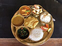
Nepali/Nepalese cuisine comprises a variety of cuisines based upon ethnicity, soil and climate relating to Nepal's cultural diversity and geography. Dal-bhat-tarkari is eaten throughout Nepal. Dal is a soup made of lentils and spices, served over boiled grain, bhat—usually rice but sometimes another grain - and a vegetable soup, tarkari. Condiments are usually small amounts of spicy pickle which can be fresh or fermented, and of which there are a considerable number of varieties. Other accompaniments may be sliced lemon (nibuwa) or lime (kagati) with fresh green chilli and a fried papad. Dhindo (ढिंडो) is a traditional food of Nepal.

Mechinagar is a municipality in Jhapa District, Province No. 1, Nepal and is the main entry point from India on Nepal's eastern border. Nepal's custom office is in Kakarvitta, a section of the municipality. The city is almost 475 km south east of the capital city Kathmandu and 115 km east of the state capital of Province One Biratnagar.

Sel roti is a traditional homemade ring-shaped sweet rice bread popular in Nepal and the Kumaon region of India. It is mostly prepared during Dashain and Tihar, widely celebrated Hindu festivals in Nepal and Sikkim and Darjeeling regions in India where ethnic Nepalese people have presence. It is known as shinghal in Kumaon.
Birtamode is a municipality in Jhapa District of Nepal. It is the commercial, educational and transport hub of Jhapa District. Sarnamati Bazar, Dhulabari Bazar, Dhaijan Bazar, Charali Bazar, Shivasatakshi Bazar, Kamatoli Bazar, Chakchaki Bazar and Surunga Bazar are some of the nearest local towns/settlements connected to Birtamod. it is one of the fastest growing city in Nepal. Birtamod is the largest city of Jhapa as well as in Mechi zone.

Lakshmi Puja or Lakshmi Pooja, is a Hindu religious festival that falls on Amavasya of Krishna Paksha in the Vikram Samvat Hindu calendar month of Kartik, on the third day of Deepawali and is considered as the main festive day of Deepawali.

Tokha Chandeshwari is a village and former Village Development Committee that is now part of Tokha Municipality in Kathmandu District in Province No. 3 of central Nepal. At the time of the 2011 Nepal census it had a population of 3961. Tokha Chandeshwari now is part of Tokha municipality.
Puranchaur is a former Village Development Committee in Kaski District in the Gandaki Province of northern-central Nepal. It is now annexed to Pokhara metropolitan city, and is ward no. 19 of it. At the time of the 2011 Nepal census it had a population of 3,597 persons living in 865 individual households.

Kataiya ( ) is a village development committee (VDC) in the central part of Saptari in the Sagarmatha Zone of south-eastern part of Nepal. This VDC is about 5km south of Rupani bazaar, a bazaar through which the East-West Highway passes and about 15km north of Indo-Nepal border. It is about 8km north-west of the headquarter of Saptari district as well as Sagarmatha zone, Rajbiraj. The VDC comprises 9 wards. It lies in Illaka No. 11. On the basis of 2011AD. census, there are 9,554 population living in about 1,500 individuals houses.
Khudunabari is a village development committee in Jhapa District in the Province No. 1 of south-eastern Nepal. At the time of the 1991 Nepal census, it had a population of 10,674 people living in 1867 individual households. It is connected via Sanischare Road to Mahendra Highway. Its neighbouring VDC s are Arjundhara, Lakshmipur and Shantipur of Illam District. It area comprises both plain and hilly. It has a moderate climate.
Jante is a village development committee in Morang District in the Kosi Zone of south-eastern Nepal. At the time of the 1991 Nepal census it had a population of 5622 people living in 1010 individual households. It contains various communities like Limbu, Rai, Brahmin, Chettri, Magar and Newar.It contains many temples and church. This village development committee is connected by the Jante-Pathari and Jante-Letang highways.
Rajghat is a small village in the Urlabari Municipality, comprises two wards; 8 and 9 in the Morang District in the Koshi Zone of south-eastern Nepal. It is located in North-East part of Morang and 1.5 kilometers south of the East West national highway of Nepal. Durgapuri Bazar is the central emerging town of Rajghat.

Rice production in India is an important part of the national economy.
Ashwin, also known as Ashoj, is the sixth month in the Bikram Sambat, the official Nepali calendar. This month coincides with September 17 to October 17 of the Western Calendar and is 31 days long.

Farming Systems in India are strategically utilized, according to the locations where they are most suitable. The farming systems that significantly contribute to the agriculture of India are subsistence farming, organic farming, industrial farming. Regions throughout India differ in types of farming they use; some are based on horticulture, ley farming, agroforestry, and many more. Due to India's geographical location, certain parts experience different climates, thus affecting each region's agricultural productivity differently. India is very dependent on its monsoon cycle for large crop yields. India's agriculture has an extensive background which goes back to at least 9 thousand years. In India, Agriculture was established throughout most of the subcontinent by 6000–5000 BP. During the 5th millennium BP, in the alluvial plains of the Indus River in Pakistan, the old cities of Mohenjo-Daro and Harappa experienced an apparent establishment of an organized farming urban culture. That society, known as the Harappan or Indus civilization, flourished until shortly after 4000 BP; it was much more comprehensive than those of Egypt or Babylonia and appeared earlier than analogous societies in northern China. Currently, the country holds the second position in agricultural production in the world. In 2007, agriculture and other industries made up more than 16% of India's GDP. Despite the steady decline in agriculture's contribution to the country's GDP, agriculture is the biggest industry in the country and plays a key role in the socio-economic growth of the country. India is the second-largest producer of wheat, rice, cotton, sugarcane, silk, groundnuts, and dozens more. It is also the second biggest harvester of vegetables and fruit, representing 8.6% and 10.9% of overall production, respectively. The major fruits produced by India are mangoes, papayas, sapota, and bananas. India also has the biggest number of livestock in the world, holding 281 million. In 2008, the country housed the second largest number of cattle in the world with 175 million.

Hattikilla (Nep:हात्तिकिल्ला)(Hətte-Kellə) is a village in Shani-Arjun Municipality in Jhapa District of eastern Nepal.

Dakneshwori Municipality is located in Saptari District in Province 2 of Nepal. It was formed in 2016 occupying current 10 sections (wards) merging previous Kabilasha, Hariraha, Tarhi, Bhuthi, Pato, Aurahi, Brahampur, Gamahariya Parwaha, Patthargada and Banaula VDCs. It occupies an area of 69.11 km2 with a total population of 44,782. Dakneshwori Municipality is named after the famous temple Dakneshwori Bhagwati located at ward no. 5, Pato.


