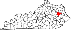
Dingus, Kentucky

Last updated

Dingus, Kentucky
USA Kentucky location map.svg
Red pog.svg
Dingus
Usa edcp location map.svg
Red pog.svg
Dingus
Coordinates: 37°54′29″N83°06′08″W / 37.90806°N 83.10222°W / 37.90806; -83.10222
Country United States
State Kentucky
County Morgan
Elevation
883 ft (269 m)
Time zone UTC-5 (Eastern (EST))
  Summer (DST) UTC-4 (EDT)
GNIS feature ID507856

Dingus is an unincorporated community in Morgan County, Kentucky on Kentucky Highway 437, between Elamton and Mima. The town is located 14 miles from West Liberty, the county seat. There was formerly a post office in the town, [1] but residents are now served by the post office at Elkfork, Kentucky (41421). Dingus lies at an elevation of 883 feet (269 m). [2]

The community was named for early postmaster Charles B. Dingus. [3]

Related Research Articles

<span class="mw-page-title-main">Trimble County, Kentucky</span> County in Kentucky, United States

Trimble County is a county located in the north central part of the U.S. state of Kentucky. Its county seat is Bedford. The county was founded in 1837 and is named for Robert Trimble. Trimble is no longer a prohibition or dry county. Trimble County is part of the Louisville/Jefferson County, KY–IN Metropolitan Statistical Area.

<span class="mw-page-title-main">Martin, Kentucky</span> City in Kentucky, United States

Martin is a home rule-class city in Floyd County, Kentucky, in the United States. The population was 634 as of the 2010 census.

Neatsville is an unincorporated community in Adair County, in the U.S. state of Kentucky. It is located at the junction of Kentucky Route 206 and Kentucky Route 76. Its elevation is 705 feet (215 m). For unknown reasons, the town's name was spelled as Neetsville from 1876 until 1886, when the town's post office closed. In its early history from around the 1810s to 1900, Neatsville progressively grew to become a well-established, incorporated town. It has been relocated twice through the years, once due to flooding circa 1900–1902, which decimated the town, and once in the 1960s when the Green River was impounded to make way for the Green River Reservoir.

<span class="mw-page-title-main">Coxs Creek, Kentucky</span> Unincorporated community in Kentucky, United States

Coxs Creek is an unincorporated community along U.S. Routes 31E/150 in Nelson County, Kentucky, United States, 4½ miles north of the county seat of Bardstown. It is named for Colonel Isaac Cox of Pennsylvania, who built a "fort" at the site in April 1775 before he fought in the American Revolutionary War, with the help of his brother James. The land had actually been his father's, but David moved back to Virginia before he developed it. More of a station, Cox's 1,000 acres (4.0 km2) was said to be the first pioneer station in Nelson County. Isaac Cox would later be the last white man to be killed by Indians during the time of the great Indian wars in what later became Kentucky.

Hi Hat is an unincorporated community and coal town located in Floyd County, Kentucky, United States. Its post office is still open.

<span class="mw-page-title-main">Hot Spot, Kentucky</span> Unincorporated community in Kentucky, United States

Hot Spot is an unincorporated community and former coal town in Letcher County, Kentucky, United States. It was named for the Hot Spot Coal Company. Other names for the community have been Smoot Creek, Dalna, Elsiecoal, and Premium. It has frequently been noted on lists of unusual place names.

Halfway is an unincorporated community in Allen County, Kentucky, United States.

Aflex is an unincorporated community and coal town in Pike County, Kentucky, United States.

Fusonia is an unincorporated community and coal town in Perry County, Kentucky, United States.

Christopher is an unincorporated community and coal town in Perry County, Kentucky, United States. Their post office has been closed.

Burdine is an unincorporated community and coal town in Letcher County, Kentucky, United States.

<span class="mw-page-title-main">Cromona, Kentucky</span> Unincorporated community in Kentucky, United States

Cromona is a small unincorporated community located in the mountains of Eastern Kentucky in Letcher County, Kentucky, United States. The Cromona post office has operated since 1916. Cromona is actually known as Haymond by the local residents. However, for reasons that are obscure, the post office was given a different name, Cromona. It was built as a coal town in 1916, and was named for the president of the Elk Horn Coal Corporation, Thomas S. Haymond. The population of Haymond was 502 as of the 2010 census.

Hellier is an unincorporated community and coal town in Pike County, Kentucky, United States.

Ivel is an unincorporated community and coal town in Floyd County, Kentucky, United States.

Ages is an unincorporated coal town and census-designated place (CDP) in Harlan County, Kentucky, United States.

Kildav is an unincorporated community and coal town in Harlan County, Kentucky, United States. Its post office is closed. The name is a combination of Killebrew and Davis, owners of the King Harlan Coal Company.

Custer is an unincorporated community within Breckinridge County, Kentucky, United States.

Harveyton is an unincorporated community located in Perry County, Kentucky, United States.

Trace Fork or Trace Branch is a creek in Perry County, Kentucky in the United States. It a fork of Lotts Creek 1 mile (1.6 km) upstream from the latter's mouth at an altitude of 825 feet (251 m).

Lenoxburg is an unincorporated community in Bracken and Pendleton counties, in the U.S. state of Kentucky.

References

  1. USGS
  2. U.S. Geological Survey Geographic Names Information System: Dingus, Kentucky
  3. Rennick, Robert M. (1987). Kentucky Place Names. University Press of Kentucky. p. 82. ISBN   0813126312 . Retrieved April 28, 2013.