Ezel, Kentucky

Last updated

Ezel, Kentucky
USA Kentucky location map.svg
Red pog.svg
Ezel
Usa edcp location map.svg
Red pog.svg
Ezel
Coordinates: 37°53′28″N83°26′40″W / 37.89111°N 83.44444°W / 37.89111; -83.44444
Country United States
State Kentucky
County Morgan
Area
[1]
  Total
0.89 sq mi (2.30 km2)
  Land0.89 sq mi (2.29 km2)
  Water0.00 sq mi (0.01 km2)
Elevation
945 ft (288 m)
Population
 (2020) [2]
  Total
209
  Density236.16/sq mi (91.16/km2)
Time zone UTC-5 (Eastern (EST))
  Summer (DST) UTC-4 (EDT)
ZIP code
41425
FIPS code 21-25876
GNIS feature ID512105

Ezel (also Ecell and Ezell) is an unincorporated community and census-designated place (CDP) in Morgan County, Kentucky, United States. As of the 2020 census, it had a population of 209. [2] It has a small post office, with the ZIP code 41425. [3]

Contents

History

First incorporated in 1882, the town was given the name "Ezel", for a rock in the Bible, by its first postmaster, Eli Pieratt, when the post office opened in 1875. [4] [5] It is now home to Ezel Elementary School and the Blackwater Volunteer Fire Department.

Geography

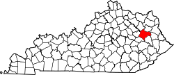
Ezel lies along U.S. Route 460, 14 miles (23 km) west of the city of West Liberty, the county seat of Morgan County. [6] Frenchburg is 12 miles (19 km) further west along US 460. The elevation of Ezel is 945 feet (288 m). [7]

According to the U.S. Census Bureau, the Ezel CDP has a total area of 0.89 square miles (2.31 km2), of which 0.004 square miles (0.010 km2), or 0.45%, are water. [1] Blackwater Creek runs along the southeast edge of the community, leading northeast to the Licking River near Kellacey.

Demographics

Historical population
CensusPop.Note
2010 235
2020 209−11.1%
U.S. Decennial Census [8]

References

  1. 1 2 "2022 U.S. Gazetteer Files: Kentucky". United States Census Bureau. Retrieved May 22, 2023.
  2. 1 2 "P1. Race – Ezel CDP, Kentucky: 2020 DEC Redistricting Data (PL 94-171)". U.S. Census Bureau. Retrieved May 22, 2023.
  3. USPS – Cities by ZIP Code
  4. Ky Atlas & Gazetteer
  5. Rennick, Robert M. (1987). Kentucky Place Names. University Press of Kentucky. p. 97. Retrieved April 28, 2013.
  6. Rand McNally. The Road Atlas '06. Chicago: Rand McNally, 2006, p. 43.
  7. U.S. Geological Survey Geographic Names Information System: Ezel, Kentucky, Geographic Names Information System, 1979-09-20. Accessed 2008-01-03.
  8. "Census of Population and Housing". Census.gov. Retrieved June 4, 2016.