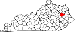
Wrigley, Kentucky | |
---|---|
Coordinates: 38°1′6″N83°16′17″W / 38.01833°N 83.27139°W | |
Country | United States |
State | Kentucky |
County | Morgan |
Elevation | 817 ft (249 m) |
Time zone | UTC-5 (Eastern (EST)) |
• Summer (DST) | UTC-4 (EDT) |
GNIS feature ID | 516490 |
Wrigley is an unincorporated community in Morgan County, Kentucky, United States. It lies along Route 7, north of the city of West Liberty, the county seat of Morgan County. [1] It has a post office with the ZIP code 41477. [2]
The climate in this area is characterized by relatively high temperatures and evenly distributed precipitation throughout the year. The Köppen Climate System describes the weather as humid subtropical, and uses the abbreviation Cfa. [3]
Climate data for Wrigley, Kentucky | |||||||||||||
---|---|---|---|---|---|---|---|---|---|---|---|---|---|
Month | Jan | Feb | Mar | Apr | May | Jun | Jul | Aug | Sep | Oct | Nov | Dec | Year |
Mean daily maximum °C (°F) | 6 (43) | 8 (47) | 14 (57) | 20 (68) | 25 (77) | 29 (84) | 31 (87) | 30 (86) | 27 (80) | 21 (70) | 14 (57) | 8 (46) | 19 (67) |
Mean daily minimum °C (°F) | −7 (20) | −6 (21) | −1 (30) | 3 (38) | 9 (48) | 14 (57) | 17 (62) | 16 (60) | 11 (52) | 4 (39) | −1 (30) | −5 (23) | 4 (40) |
Average precipitation mm (inches) | 86 (3.4) | 81 (3.2) | 110 (4.2) | 89 (3.5) | 110 (4.2) | 100 (4) | 130 (5.3) | 97 (3.8) | 81 (3.2) | 66 (2.6) | 81 (3.2) | 91 (3.6) | 1,120 (44.2) |
Source: Weatherbase [4] |
Athol is an unincorporated community in Lee County, Kentucky, United States. It lies along Route 52 east of the city of Beattyville, the county seat of Lee County. Its elevation is 761 feet (232 m). It has a post office with the ZIP code 41307.
Heidelberg is an unincorporated community in Lee County, Kentucky, United States. It lies along Route 399 southwest of the city of Beattyville, the county seat of Lee County. Its elevation is 718 feet (219 m), and it is located at (37.5553639|-83.7788073). It no longer has a post office and the ZIP code is now 41311, same as Beattyville. Said post office was established in 1904, and is said to be named for the hometown of an early German-American settler.
Saint Helens is an unincorporated community in Lee County, Kentucky, in the United States. It lies along Route 52 east of the city of Beattyville, the county seat of Lee County. Its elevation is 728 feet (222 m). It has a post office with the ZIP code 41368. This post office preëmpted the naming of a community in Jefferson County as Saint Helens; instead, it had to adopt the name "Shively" after an early settler.
Zoe is an unincorporated community in Lee County, Kentucky, United States. It lies north of the city of Beattyville, the county seat of Lee County, along Route 11. Its elevation is 1,145 feet (349 m). It has a post office with the ZIP code 41397.
Elk Horn is an unincorporated community in Taylor County, Kentucky, United States. It lies along Route 76 southeast of the city of Campbellsville, the county seat of Taylor County. Its elevation is 735 feet (224 m). It has a post office with the ZIP code 42733.
Isonville is an unincorporated community in Elliott County, Kentucky, United States. It lies along Routes 32 and 486 east of the city of Sandy Hook, the county seat of Elliott County. Its elevation is 709 feet (216 m). It has a post office with the ZIP code 41149.
Oil Springs is an unincorporated community in Johnson County, Kentucky, United States. It lies along Route 40 west of the city of Paintsville, the county seat of Johnson County. It has a post office with the ZIP code 41238.
Falcon is an unincorporated community in Magoffin County, Kentucky, United States. It lies along Route 40 northeast of the city of Salyersville, the county seat of Magoffin County. Its elevation is 974 feet (297 m). It has a post office with the ZIP code 41426.
Gunlock is an unincorporated community in Magoffin County, Kentucky, United States. It lies along Route 7 southeast of the city of Salyersville, the county seat of Magoffin County. Its elevation is 1,001 feet (305 m).
Denniston is an unincorporated community in Menifee County, Kentucky, United States. It lies along U.S. Route 460 and Kentucky Route 746, southeast of the city of Frenchburg, the county seat of Menifee County. Its elevation is 1,106 feet (337 m). It has a post office with the ZIP code 40316.
Wellington is an unincorporated community in Menifee County, Kentucky, United States. It lies along U.S. Route 460 and Kentucky Route 1693 southeast of the city of Frenchburg, the county seat of Menifee County. Its elevation is 1,194 feet (364 m). It has a post office with the ZIP code 40387.
Crockett is an unincorporated community in Morgan County, Kentucky, United States. It lies along Route 172 northeast of the city of West Liberty, the county seat of Morgan County. Its elevation is 912 feet (278 m). It has a post office with the ZIP code 41413.
Elkfork is an unincorporated community in Morgan County, Kentucky, United States. It lies along Route 172, northeast of the city of West Liberty, the county seat of Morgan County. Its elevation reaches up to 856 feet (261 m). Although the area is unincorporated, Elkfork contains a post office, with the ZIP code of 41421.
Ezel is an unincorporated community and census-designated place (CDP) in Morgan County, Kentucky, United States. As of the 2020 census, it had a population of 209. It has a small post office, with the ZIP code 41425.
Mize is an unincorporated community in Morgan County, Kentucky, United States. It lies along U.S. Route 460 and Kentucky Route 203, southwest of the city of West Liberty, the county seat of Morgan County. Its elevation is 817 feet (249 m). It has a post office with the ZIP code 41352.
Malone is an unincorporated community in Morgan County, Kentucky, United States. It lies along Route 191 south of the city of West Liberty, the county seat of Morgan County. Its elevation is 797 feet (242 m). It has a post office with the ZIP code 41451.
Kirkland is an unincorporated community in central Yavapai County, Arizona, United States, near the Weaver Mountains. It is southwest of the city of Prescott, the county seat of Yavapai County. Its elevation is 3,930 feet (1,198 m). Although Kirkland is unincorporated, it has a post office, with the ZIP code of 86332.
Aladdin is a 30-acre hamlet in eastern Crook County, Wyoming, United States, lying at the junction of Wyoming routes 24 and 111, 20 miles northeast of Sundance, the county seat. Although Aladdin is unincorporated, it has a post office, with the ZIP code of 82710; the post office is located in the town's general store, which was established in 1896, serving as a commissary for coal miners working at the Aladdin Coal Tipple, about a mile up the street, where coal was mined until 1942.
Arminto is an unincorporated community in northwestern Natrona County, Wyoming, United States. It lies along local roads west of the city of Casper, the county seat of Natrona County. Its elevation is 6,053 feet (1,845 m).
Acton is an Census Designated Place in northwestern Yellowstone County, Montana, United States. It has a postal ZIP code (59002) and lies along Montana Highway 3 northwest of the city of Billings, the county seat of Yellowstone County.