District of Columbia (until 1871)

Last updated
Animated map of the District of Columbia. The city of Washington was not incorporated until 1802. Dcmapanimated.gif
Animated map of the District of Columbia. The city of Washington was not incorporated until 1802.

The District of Columbia was created in 1801 as the federal district of the United States, with territory previously held by the states of Maryland and Virginia ceded to the federal government of the United States for the purpose of creating its federal district, which would encompass the new national capital of the United States, the City of Washington. The district came into existence, with its own judges and marshals, through the District of Columbia Organic Act of 1801; previously it was the Territory of Columbia. According to specific language in the U.S. Constitution, it was 100 square miles (259 km2).

Contents

The district encompassed three small cities: Alexandria, formerly in Virginia, Georgetown, formerly Maryland, and the deliberately planned central core, the City of Washington. Both the White House and the United States Capitol were already completed and in use by 1800 as called for by the 1791 L'Enfant Plan for the City of Washington, although the city was not formally chartered until 1802. Beyond those cities, the remainder of the district was farmland organized by the 1801 Act into two counties, Washington County, D.C., on the Maryland side, and Alexandria County, D.C., on the Virginia side, encompassing today's Arlington County, Virginia, and the independent city of Alexandria.

The district was governed directly by the U.S. Congress from the beginning. Alexandria City and County were ceded back from the federal government to the commonwealth of Virginia in 1846, in a process known as retrocession, anticipating the 1850 ban on slave trading (but not slavery) in the district.

Washington and Georgetown retained their separate charters for seventy years, until the District of Columbia Organic Act of 1871. That act cancelled the charters of the towns and brought the entire area within the district borders under one district government, ending any distinction between "the District of Columbia" and "Washington", making the two terms effectively synonymous. [1]

Choice of location

Congress determined, in the Residence Act of 1790, that the nation's capital be on the Potomac, between the Anacostia River and today's Williamsport, Maryland, and in a federal district up to 10 miles square. The exact location was to be determined by President George Washington, familiar with the area from his nearby home and properties at Mt. Vernon, Virginia.

Its trans-state location reflected a compromise between the Southern and Northern states. Virginia lobbied for the selection, an idea opposed by New York and Pennsylvania, both of which had previously housed the nation's capital. Maryland, whose State House was older than that of Virginia, and like Virginia a slave state, was chosen as a compromise. At Washington's request the City of Alexandria was included in the district, though with the provision that no federal buildings could be built there. The new capital district was at about the center of the country.

About 2/3 of the original district was in Maryland and 1/3 in Virginia, and the wide Potomac in the middle. The future district was surveyed in 1791–92; 24 of its surviving stone markers are in Maryland, 12 in Virginia. (See Boundary Markers of the original District of Columbia.) Washington decided that the capital's location would be located between the mouth of the Anacostia River and Georgetown, which sits at the Potomac's head of navigation.

Political representation

Map of the District, 1835 Map of Washington and Alexandria County in 1835.jpg
Map of the District, 1835

Governing bodies

As specified by Article One of the United States Constitution, in fact as one of the enumerated powers of section 8, Congress assumed direct administrative control of the federal district upon its creation by the District of Columbia Organic Act of 1801. There was no district governor or executive body. The U.S. House created a permanent Committee on the District of Columbia in January 1808, and the U.S. Senate established its counterpart in December 1816. These committees remained active until 1946. [2] Thus the U.S. Congress managed the detailed day-to-day governmental needs of the district through acts of Congress—an act authorizing the purchase of fire engines and construction of a firehouse, for instance, [3] or an act to commission three new city streets and closing two others in Georgetown. [4]

The five component parts of the district operated their own governments at the lower level. The three cities within the district (Georgetown, the City of Washington, and Alexandria) operated their own municipal governments, each with a continuous history of mayors. Robert Brent, the first mayor of the City of Washington, was appointed directly by Thomas Jefferson in 1802 after the city's organization that year.

The remaining rural territory within the district belonged either to Alexandria County D.C., (district land west of the Potomac outside the City of Alexandria, formerly in Virginia) or to Washington County, D.C., (the unincorporated east side, formerly in Maryland, plus islands and riverbed). Both counties operated with boards of commissioners for county-level government functions. Both counties were governed by levy courts made of presidentially appointed Justices of the Peace. Prior to 1812, the levy courts had a number of members defined by the president, but after that Washington County had 7 members. In 1848, the Washington County levy court was expanded to 11 members, and in 1863 that was reduced by two to nine members.

Disenfranchisement

The language of the establishing act of 1801 omitted any provision for district residents to vote for local, state-equivalent, or federal representatives.

This omission was not related to any constitutional restriction or, apparently, any rationale at all. Legal scholars in 2004 called the omission of voting rights a simple "historical accident", pointing out that the preceding Residence Act of July 16, 1790, exercising the same constitutional authority over the same territory around the Potomac, had protected the votes of the district's citizens in federal and state elections. Those citizens had indeed continued to cast ballots, from 1790 through 1800, for their U.S. House representatives and for their Maryland and Virginia state legislators. [5] James Madison had written in the Federalist No. 43 that the citizens of the federal district should "of course" have their will represented, "derived from their own suffrages." [6] The necessary language simply did not appear in the 1801 legislation.

The prospect of disenfranchisement caused immediate concern. One voice from a public meeting in January 1801, before the bill's passage, compared their situation to those who fought against British taxation without representation in the Revolutionary War—20 years prior. [7] Despite these complaints the bill went into effect as written. Given exclusive and absolute political control, Congress did not act to restore any of these rights until the 1960s. The district still has no voting representation in Congress, and the decisions of its long-sought local government established in 1973 are still subject to close congressional review, annulment, and budget control. [8]

Retrocession (1847)

Residents of Alexandria saw no economic advantage from being in the District. No federal buildings could be built on the south side of the Potomac, nor did they have representation in Congress. Some resistance was expressed immediately. One leading figure in the fight to retrocede through the 1820s was Thomson Francis Mason, who was elected mayor of Alexandria, D.C., four times between 1827 and 1830. Also Alexandria was a center of the profitable slave trade – the largest slave-trading company in the country, Franklin and Armfield, was located there – and Alexandria residents were afraid that if the District banned the slave trade, as seemed likely, this industry would leave the city.

To prevent this, Arlington held a referendum, through which voters petitioned Congress and the state of Virginia to return the portion of the District of Columbia south of the Potomac River (Alexandria County) to Virginia. On July 9, 1846, Congress retroceded Alexandria County to Virginia, after which the district's slave traders relocated to Alexandria. [9] :292 [10] The district's slave trade was outlawed in the Compromise of 1850. [11] The penalty for bringing a slave into the district for sale, was freedom for the slave. [12] Southern senators and congressmen resisted banning slavery altogether in the District, to avoid setting a precedent. The practice remained legal in the district until after secession, with the District of Columbia Compensated Emancipation Act signed by Lincoln on April 16, 1862, which established the annual observance of Emancipation Day.

Organic Act of 1871

The District of Columbia Organic Act of 1871 created a single new district corporation [13] governing the entire federal territory, called the District of Columbia, thus dissolving the three major political subdivisions of the district (Port of Georgetown, the City of Washington, and Washington County) and their governments. By this time the county also contained other small settlements and nascent suburbs of Washington outside its bounded limits, such as Anacostia, which had been incorporated in 1854 as Uniontown; Fort Totten, dating at least to the Civil War; and Barry Farm, a large tract bought by the Freedmen's Bureau and granted to formerly enslaved and free-born African Americans in 1867.

The newly restructured district government provided for a governor appointed by the president for a 4-year term, with an 11-member council also appointed by the president, a locally elected 22-member assembly, and a five-man Board of Public Works charged with modernizing the city. [14] The first vice-chair of that Board of Public Works was real-estate developer Alexander Robey Shepherd, the architect and proponent of the consolidating legislation. From September 1873 to June 1874, Shepherd would serve as the second, and final, governor of the District.

The Seal of the District of Columbia features the date 1871, recognizing the year the district's government was incorporated. [15]

Related Research Articles

<span class="mw-page-title-main">Arlington County, Virginia</span> County in Virginia, United States

Arlington County is a county in the U.S. state of Virginia. The county is located in Northern Virginia on the southwestern bank of the Potomac River directly across from Washington, D.C.. The county is coextensive with the U.S. Census Bureau's census-designated place of Arlington. Arlington County is the second-largest city in the Washington metropolitan area, although it does not have the legal designation of an independent city or incorporated town under Virginia state law.

<span class="mw-page-title-main">Washington, D.C.</span> Capital city of the United States

Washington, D.C., formally the District of Columbia and commonly known as Washington or D.C., is the capital city and federal district of the United States. The city is located on the east bank of the Potomac River, which forms its southwestern border with Virginia, and borders Maryland to its north and east. The city was named for George Washington, a Founding Father, commanding general of the Continental Army in the American Revolutionary War, and the first president of the United States, and the district is named for Columbia, the female personification of the nation.

<span class="mw-page-title-main">Georgetown (Washington, D.C.)</span> Place in the United States

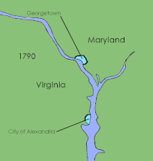
Georgetown is a historic neighborhood and commercial district of Washington, D.C., in Northwest D.C., situated along the Potomac River. Founded in 1751 in the Province of Maryland, the port of Georgetown predated the establishment of the federal district and the City of Washington by 40 years. Georgetown remained a separate municipality until 1871 when the United States Congress created a new consolidated government for the whole District of Columbia. A separate act, passed in 1895, specifically repealed Georgetown's remaining local ordinances and renamed Georgetown's streets to conform with those in the City of Washington.

<span class="mw-page-title-main">Council of the District of Columbia</span> Legislative branch of the D.C. government

The Council of the District of Columbia is the legislative branch of the government of the District of Columbia. As permitted in the United States Constitution, the district is not part of any U.S. state and is overseen directly by the federal government.

<span class="mw-page-title-main">Residence Act</span> 1790 U.S. law establishing the national capital city of Washington, D.C.

The Residence Act of 1790, officially titled An Act for establishing the temporary and permanent seat of the Government of the United States, is a United States federal statute adopted during the second session of the First United States Congress and signed into law by President George Washington on July 16, 1790. The Act provides for a national capital and permanent seat of government to be established at a site along the Potomac River and empowered President Washington to appoint commissioners to oversee the project. It also set a deadline of December 1800 for the capital to be ready, and designated Philadelphia as the nation's temporary capital while the new seat of government was being built. At the time, the federal government was operating out of New York City.

<span class="mw-page-title-main">District of Columbia home rule</span> Autonomous rule in the United States capital

District of Columbia home rule is the District of Columbia residents' ability to govern their local affairs. As the federal capital, the Constitution grants the United States Congress exclusive jurisdiction over the District in "all cases whatsoever".

<span class="mw-page-title-main">Washington County, D.C.</span> Original political entity within the District of Columbia

The County of Washington was one of five original political entities within the District of Columbia, the capital of the United States. Formed by the Organic Act of 1801 from parts of Montgomery and Prince George's County, Maryland, Washington County referred to all of the District of Columbia "on the east side of the Potomac, together with the islands therein." The bed of the Potomac River was considered to be part of Washington County as well.

<span class="mw-page-title-main">History of Washington, D.C.</span> History of the US capital

The history of Washington, D.C., is tied to its role as the capital of the United States. The site of the District of Columbia along the Potomac River was first selected by President George Washington. The city came under attack during the War of 1812 in an episode known as the Burning of Washington. Upon the government's return to the capital, it had to manage the reconstruction of numerous public buildings, including the White House and the United States Capitol. The McMillan Plan of 1901 helped restore and beautify the downtown core area, including establishing the National Mall, along with numerous monuments and museums.

<span class="mw-page-title-main">District of Columbia retrocession</span> Return of some land of the District of Columbia to Virginia

The 
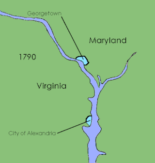
District of Columbia retrocession is the act of returning some or all of the land that had been ceded to the federal government of the United States for the purpose of creating its federal district for the new national capital of the United States, the City of Washington. The land was originally ceded to the federal government by Virginia and Maryland in 1790. After moving through various stages of federal and state approval, the Virginia portion was eventually returned in March 1847. The Maryland portion still constitutes the District of Columbia today, but at various times some have proposed retroceding it, in part or in whole, to address issues related to the voting rights of residents of the District of Columbia.

<span class="mw-page-title-main">Geography of Washington, D.C.</span> Overview of the geographical features of Washington, D.C.

Washington, D.C. is located in the Mid-Atlantic region of the United States at 38°53′42″N77°02′11″W, the coordinates of the Zero Milestone, on The Ellipse. According to the United States Census Bureau, the city has a geographical area of 68.3 square miles (176.9 km2), 61.4 square miles (159.0 km2) of which is land, and the remaining 6.9 square miles (17.9 km2) (10.16%) of which is water.

<span class="mw-page-title-main">Streetcars in Washington, D.C.</span> Streetcars that existed in Washington until 1962

Streetcars in Washington, D.C. transported people across the city and region from 1862 until 1962.

The streets and highways of Washington, D.C., form the core of the surface transportation infrastructure in Washington, D.C., the federal capital of the United States. Given that it is a planned city, the city's streets follow a distinctive layout and addressing scheme. There are 1,500 miles (2,400 km) of public roads in the city, of which 1,392 miles (2,240 km) are owned and maintained by city government.

<span class="mw-page-title-main">District of Columbia Organic Act of 1871</span> Act of Congress

The District of Columbia Organic Act of 1871 is an Act of Congress that repealed the individual charters of the cities of Washington and Georgetown and established a new territorial government for the whole District of Columbia. Though Congress repealed the territorial government in 1874, the legislation was the first to create a single municipal government for the federal district.

The District of Columbia Organic Act of 1801, officially An Act Concerning the District of Columbia, is an organic act enacted by the United States Congress in accordance with Article 1, Section 8 of the United States Constitution. It formally placed the District of Columbia under the control of the United States Congress and organized the territory within the district into two counties: Washington County to the north and east of the Potomac River and Alexandria County to the west and south. The charters of the existing cities of Georgetown and Alexandria were left in place and no change was made to their status. The common law of both Maryland and Virginia remained in force within the district. A court was established in each of the new counties.

<span class="mw-page-title-main">John Mason (planter)</span> Early American merchant, banker, and planter (1766–1849)

John Mason was an early American merchant, banker, officer, and planter. As a son of George Mason, a Founding Father of the United States, Mason was a scion of the prominent Mason political family.

<span class="mw-page-title-main">History of Alexandria, Virginia</span>

The history of Alexandria, Virginia, begins with the first European settlement in 1695. Over the next century, the town became a significant port. In 1801, much of Alexandria was swept into the new District of Columbia; it was damaged along with much of the rest of the capital during the War of 1812. In 1846, Alexandria was returned to Virginia, along with the rest of the District's territory on the western side of the Potomac River. After Virginia seceded in 1861, Alexandria was swiftly captured by Union forces and held for the remainder of the American Civil War. In the late 20th century, Alexandria became a key part of the rapidly growing Northern Virginia region.

The following is a timeline of the history of Washington, D.C., the capital city of the United States.

<span class="mw-page-title-main">2016 Washington, D.C., statehood referendum</span> District of Columbia referendum in support of becoming a U.S. state

A referendum on statehood for the District of Columbia was held on November 8, 2016. It was the first referendum on statehood to be held in the district. The District of Columbia was created following the passage of the Residence Act on July 9, 1790, which approved the creation of a national capital, the City of Washington on the Potomac River.

<span class="mw-page-title-main">Washington, D.C., Admission Act</span> Proposed bill in the United States Congress

The Washington, D.C., Admission Act, often referred to simply as the D.C. Admission Act, is a bill introduced during the 116th United States Congress. The bill would grant Washington, D.C., admission into the Union as a state and make it the country's first and only city-state. The bill was originally introduced in the 116th Congress on January 3, 2019, and was reintroduced on January 4, 2021, and January 9, 2023, in the 117th and 118th Congresses. The United States House of Representatives passed it on April 22, 2021.

References

  1. Weiner, Aaron (24 January 2014). "What is "Washington"?". Washington City Paper. Archived from the original on 14 January 2019. Retrieved 14 January 2019.
  2. "Congressional Committees on the District of Columbia, 1808–1946" (PDF). National Archives and Records Administration. US Gov't. Archived (PDF) from the original on 20 July 2017. Retrieved 11 January 2019.
  3. act of March 3, 1819, Congressional Edition, Volume 284. US GPO. 1 January 1836. p. 27. Archived from the original on 24 May 2021. Retrieved 11 January 2019.
  4. act of June 14, 1813, Acts of the Thirteenth Congress of the United States (PDF). US GPO. 1 January 1846. p. 41. Archived (PDF) from the original on 6 October 2019. Retrieved 11 January 2019.
  5. "Statement of the ABA regarding H.R. 5388, THE DISTRICT OF COLUMBIA FAIR AND EQUAL HOUSE VOTING RIGHTS ACT" (PDF). American Bar Association. Archived from the original (PDF) on 13 January 2019. Retrieved 11 January 2019.
  6. Madison, James. "Federalist No. 43". Constitution Society. Archived from the original on 2 May 2012. Retrieved 14 January 2019.
  7. Forbes-Lindsay, C. H. (1908). Washington: The City and Seat of Government (PDF). Philadelphia: The John C. Winston Co. pp. 109–10. Archived (PDF) from the original on 17 November 2015. Retrieved 11 January 2019.
  8. "History of Self-Government in the District of Columbia". Council of the District of Columbia. 2008. Archived from the original on March 31, 2009. Retrieved 2019-01-11.
  9. Loewen, James W. (1999). Lies Across America. What Our Historic Sites Get Wrong . The New Press. ISBN   1565843444.
  10. Historical Society of Washington, D.C. (2004). "Get to know D.C. – Frequently Asked Questions About Washington, D.C." Archived from the original on February 6, 2007.
  11. Compromise of 1850 Heritage Society. "Banning Slave Trade in Washington DC". Archived from the original on 2013-12-20. Retrieved 2019-01-03.
  12. act of September 20, 1850, A Century of Lawmaking for a New Nation: U.S. Congressional Documents and Debates, 1774 - 1875. US Gov't Library of Congress. pp. 467–68. Archived from the original on 14 March 2017. Retrieved 14 January 2019.
  13. "a body corporate for district purposes"
  14. "An Act to provide a Government for the District of Columbia". Statutes at Large, 41st Congress, 3rd Session. Library of Congress; Feb. 21, 1871, 41st Congress, 3rd session, chap. 62, 16 Stat. 419. Archived from the original on 20 January 2013. Retrieved 12 January 2019.
  15. "Official Symbols of the District of Columbia". About DC. Archived from the original on 5 February 2006. Retrieved 12 January 2019.