Divisions of Assam

Last updated
The five divisions of Assam Divisions of Assam.svg
The five divisions of Assam

The state of Assam in India has five regional divisions, each comprising a number of districts. The person responsible for the administration of a division is designated as a Divisional Commissioner.

Assam State in northeast India

Assam is a state in northeastern India, situated south of the eastern Himalayas along the Brahmaputra and Barak River valleys. Assam covers an area of 78,438 km2 (30,285 sq mi). The state is bordered by Bhutan and Arunachal Pradesh to the north; Nagaland and Manipur to the east; Meghalaya, Tripura, Mizoram and Bangladesh to the south; and West Bengal to the west via the Siliguri Corridor, a 22 kilometres (14 mi) strip of land that connects the state to the rest of India.

Contents

History

India Assam location map.svg
Red pog.svg
Red pog.svg
Red pog.svg
Red pog.svg
Red pog.svg
Red pog.svg
Red pog.svg
Red pog.svg
Red pog.svg
Location of the oldest urban centres recognised as a municipality region of Assam before 1947. [1] [2]

In 1874, Assam was constituted as a Chief Commissioner's province with the seat of the government in Shillong, the erstwhile capital of Assam, which is now in Meghalaya. To better administer the six districts of Goalpara, Kamrup, Sonitpur, Nagaon (formerly, Nowgong), Sivasagar (formerly, Sibsagar) and Lakhimpur, (the districts in the Brahmaputra valley, also called Assam Valley), the Judge of Assam Valley was given the additional charge of a commissioner in 1880. [3] In 1905, the offices of the Judge and the Commissioner were segregated in the Assam Valley; [4] in addition to adding a separate Commissioner's office for the administration of the Hill Districts and Surma Valley. [5]

Shillong City and state capital of Meghalaya, India

Shillong (;) is a hill station in the northeastern part of India and the capital of Meghalaya, which means "The Abode of Clouds". It is the headquarters of the East Khasi Hills district.Shillong is the 330th most populous city in India with a population of 143,229 according to the 2011 census. It is said that the rolling hills around the town reminded the British of Scotland. Hence, they would also refer to it as the "Scotland of the East".

Meghalaya State in North-east India

Meghalaya is a hilly state in northeastern India. The name means "the abode of clouds" in Sanskrit. The population of Meghalaya as of 2016 is estimated to be 3,211,474. Meghalaya covers an area of approximately 22,430 square kilometers, with a length to breadth ratio of about 3:1.

List of divisions

Historical divisions (until 2015)

Division NameDivisional OfficeDistricts
Hills and Barak Valley Dispur Cachar, Dima Hasao, Hailakandi, Karbi Anglong, and Karimganj
Lower Assam Guwahati Baksa, Barpeta, Bongaigaon, Chirang, Dhubri, Goalpara, Nalbari, Kamrup Metropolitan, Kamrup Rural, and Kokrajhar
North Assam Tezpur Darrang, Morigaon, Nagaon, Sonitpur, and Udalguri
Upper Assam Jorhat Dhemaji, Dibrugarh, Golaghat, Jorhat, Lakhimpur, Sivasagar, and Tinsukia

Current divisions [6]

Division NameDivisional OfficeDistrictsPopulationArea
Hills and Barak Valley Silchar Cachar, Hailakandi, and Karimganj 3,612,581
Central Assam Nagaon Dima Hasao, Hojai, East Karbi Anglong, West Karbi Anglong, Morigaon, and Nagaon 5,894,460
Lower Assam Guwahati Baksa, Barpeta, Bongaigaon, Chirang, Dhubri, Goalpara, Nalbari, Kamrup Metropolitan, Kamrup Rural, Kokrajhar, and South Salmara-Mankachar 13,179,980
North Assam Tezpur Biswanath, Darrang, Sonitpur, and Udalguri 4,246,834
Upper Assam Jorhat Charaideo, Dhemaji, Dibrugarh, Golaghat, Jorhat, Lakhimpur, Majuli, Sivasagar, and Tinsukia 7,840,943

Proposed divisions (new)

Division NameDivisional OfficeDistricts
Assam Hills Diphu Dima Hasao, East Karbi Anglong, and West Karbi Anglong
Barak Valley Silchar Cachar, Hailakandi, and Karimganj
Bodoland Kokrajhar Baksa, Chirang, Kokrajhar, and Udalguri
Central Assam Nagaon Hojai, Morigaon, and Nagaon
Kamrup Guwahati Darrang, East Kamrup, Kamrup Metropolitan, Kamrup Rural, and South Kamrup
Lower Assam Bongaigaon Barpeta, Bongaigaon, Dhubri, Goalpara, Nalbari, and South Salmara-Mankachar
North Assam Tezpur Biswanath, Lakhimpur, and Sonitpur
Upper Assam Jorhat Charaideo, Dhemaji, Dibrugarh, Golaghat, Jorhat, Majuli, Sivasagar, and Tinsukia

Municipal corporations

Municipal corporation (present)

Municipal corporation (proposed) [7]

Oldest recognised and constantly inhabited urban areas

The list of the oldest urban areas based on the earliest years of formation of the civic bodies, [8] [9] constituted before India's Independence of 1947.

Indian Independence Act 1947 United Kingdom legislation

The 1947 Indian Independence Act is an Act of the Parliament of the United Kingdom that partitioned British India into the two new independent dominions of India and Pakistan. The Act received the royal assent on 18 July 1947, and thus India and Pakistan, comprising West and East regions, came into being on 15 August.

TypeFormation periodUrban areas
Municipal board region Prior to India's independence in 1947

Notes

  1. "Urbanisation and Growth of Small Towns in Assam, India" (PDF). Rinku Manta, Research Scholar, Deptt. of Geography - Gauhati University and Dr. Jnanshree Borah, Associate Professor, Deptt. of Geography: Arya Vidyapeeth and Cotton College - Gauhati University. 2005.
  2. Report on the Administration of North East India. K. M. Mittal. 1921.
  3. "In 1879, Sir Bayley, therefore, proposed to the Government of India that the Judge of Assam Valley to be the ex-officio Commissioner of Assam Valley. High Court objected to the proposal. But Government of India approved the scheme and the Chief Commissioner invested the Judge of Assam with the powers of a Commissioner of a Division." ( Bose 1985 , p. 32)
  4. ( Bose 1985 , p. 33)
  5. ( Bose 1985 , p. 36)
  6. ( Press Trust of India & 31 Sept. 2015 )
  7. "Citizens submit memo to Sonowal, The Telegraph (Calcutta – Gauhati)". Avik Chakraborty. 21 December 2016. Retrieved 21 December 2016.
  8. "Urbanisation and Growth of Small Towns in Assam, India" (PDF). Rinku Manta, Research Scholar, Deptt. of Geography - Gauhati University and Dr. Jnanshree Borah, Associate Professor, Deptt. of Geography: Arya Vidyapeeth and Cotton College - Gauhati University. 2005.
  9. Report on the Administration of North East India. K. M. Mittal. 1921.
  10. Saikia, Dr Jugal (8 April 2016). Economics Of Informal Milk Producing Units In Assam
    – Guwahati municipal region, 1853, reconstituted 1873.
    . Notion Press. ISBN   9789352069385 . Retrieved 5 August 2016 via Google Books.
  11. "Dibrugarh Municipal Board – Dibrugarh municipal region, 1873.".
  12. "Goalpara Municipal Board-About Us – Goalpara municipal region, 1875.".
  13. "Dhubri Municipal Board – Dhubri municipal region, 1883.".
  14. "Nagaon – History – Nagaon municipal region, 1893.". Archived from the original on 2018-04-18. Retrieved 2017-04-07.
  15. "About Municipal Board – Tezpur – Tezpur municipal region".
  16. "Jorhat Municipal Board(JBM), Jorhat, Assam – Jorhat municipal region, 1909". Archived from the original on 2016-03-27.
  17. "AGP lists civic poll candidates – Golaghat municipal region, 1920" . Retrieved 5 August 2016.
  18. "Silchar Municipal Board (Silchar Municipality) Assam – Silchar Karimganj Hailakandi – Silchar municipal region, 1922". Archived from the original on 28 July 2016. Retrieved 5 August 2016.

Related Research Articles

Nagaon City in Assam, India

Nagaon, is a city and a municipal board in Nagaon district in the Indian state of Assam. It is situated 121 kilometres (75 mi) east of Guwahati. It has a population of 147,231.

The political structure of Assam in India is headed by the ceremonial post of the Governor. He is assisted by a council of ministers, headed by the Chief Minister, who are members of the Assam Assembly. In recent years the Governor has become more powerful, especially because the last two Governors have been ex-Army generals and the Army is entrusted with anti-insurgency operations against ULFA and other armed groups.

Jorhat Airport airport

Jorhat Airport also known as Rowriah Airport is located at Rowriah, 7 Kilometres South-West of Jorhat city, Assam, India. The civil enclave, run by the Airports Authority of India (AAI) is the 4th major airport in Assam, by number of passengers carried and cargo tonnage, according to the latest AAI traffic data :

Kohora Town in Assam, India

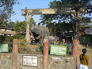
Kohora is a small town situated in the Golaghat district of Assam. It is the main entrance of the world-famous Kaziranga National Park. It lies on the National Highway 37(Asean Highway 1). Kohora Lies Between Nagaon And Golaghat.

Tourism in Assam

Roughly shaped like a bird with wings stretching along the length of the Brahmaputra river, Assam is the central state in the North-East Region of India and serves as the gateway to the rest of the Seven Sister States. The land of red river and blue hills, Assam comprises three main geographical areas: the Brahmaputra Valley which constitutes the expansive wingspan, the Barak Valley extending like a tail, and the intervening Karbi Plateau and North Cachar Hills. Assam shares its border with Meghalaya, Arunachal Pradesh, Nagaland, Manipur, Tripura, Mizoram and West Bengal; and there are National Highways leading to their capital cities. It also shares international borders with Bhutan and Bangladesh. In ancient times Assam was known as Pragjyotisha or Pragjyotishpura, and Kamarupa.

Upper – Assam is an administrative division of the state of Assam comprising the undivided Lakhimpur and Sivasagar districts, of the upper reaches of the Brahmaputra valley. The other divisions are: Lower – Assam, North Assam and Hills and Barak Valley. The division is under the jurisdiction of a Commissioner, stationed at Jorhat.

Assam Cricket Association

Assam Cricket Association is the governing body of the Cricket activities in the Assam state of India and the Assam cricket team. It is affiliated to the Board of Control for Cricket in India.

The All Assam Chess Association is a registered chess association of the Assam state of India. It was formed in the late 1960s by Bodiyuz Zaman from Jorhat. The first president of the association was Kamakhya Prasad Tripathi. It is affiliated with the All India Chess Federation and officially accredited by the Fédération Internationale des Échecs, (FIDE).

Bongaigaon Refinery Township Township in Assam, India

BGR Township is a census town in Bongaigaon Urban Agglomeration, India. It is near the National Highway 31.

Srimanta Sankaradeva University of Health Sciences

Srimanta Sankaradeva University of Health Sciences, Guwahati, Assam, India is established in 2009 as per The Srimanta Sankaradeva University of Health Sciences Act, 2007. The Srimanta Sankaradeva University of Health Sciences is the only Health Sciences University in the North Eastern Region with its jurisdiction to the whole of Assam.

The 2015 Assam State Premier League is the first season of the Assam State Premier League in its new format. Assam State Premier League alias ASPL, is the top football league for association football clubs in the Indian state of Assam. The league was re-launched in May 2015 and was kicked off on 29 May and will conclude with the final on 25 July.

Assam – 16th largest, 15th most populous and 26th most literate state of the 29 states of the democratic Republic of India. Assam is at 14th position in life expectancy and 8th in female-to-male sex ratio. Assam is the 21st most media exposed states in India. The Economy of Assam is largely agriculture based with 69% of the population engaged in it. Growth rate of Assam's income has not kept pace with that of India's during the Post-British Era; differences increased rapidly since the 1970s. While the Indian economy grew at 6 percent per annum over the period of 1981 to 2000, the same of Assam's grew only by 3.3 percent.

North Eastern Tea Association

The North Eastern Tea Association (NETA) is an association of tea producers' headquartered at Golaghat, Upper-Assam in the state of Assam, India, and is a constituent member of the Joint Forum and the Consultative Committee of Plantation Associations (CCPA), Assam Valley branch. The association promotes interests of its members, in addition to playing a pivotal for the enrichment of the tea industry in Assam.

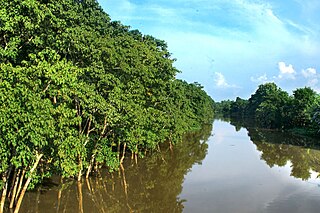
The Brahmaputra floods refers to a catastrophic flood event that occurred in 2012 along the Brahmaputra River and its tributaries, as well as in subsequent years.

References