Bodoland, officially the Bodoland Territorial Region, is an autonomous region in Assam, Northeast India. It is made up of four districts on the north bank of the Brahmaputra river below the foothills of Bhutan and Arunachal Pradesh. It is administered by an elected body known as the Bodoland Territorial Council which came into existence under the terms of a peace agreement signed in February 2003 and its autonomy was further extended by an agreement signed in January 2020. The region covers an area of over nine thousand square kilometres and is predominantly inhabited by the Bodo people and other indigenous communities of Assam.

Bongaigaon district (Prpn:ˈbɒŋgaɪˌgãʊ) is an administrative district in the state of Assam in northeastern India. The district headquarters are located at Bongaigaon. The district occupies an area of 1,093 km2.

Goalpara district is an administrative district of the Indian state of Assam.

Kokrajhar district is an administrative district in Bodoland Territorial Region of Assam. It is predominantly inhabited by the Boro tribe. The district has its headquarters located at Kokrajhar Town and occupies an area of 3,169.22 km2 (1,223.64 sq mi). It has two civil sub-divisions namely Parbatjhora and Gossaigaon and five revenue circles namely Kokrajhar, Dotma, Bhaoraguri, Gossaigaon and Bagribari.

Kamrup Rural district, or simply Kamrup district is an administrative district in the state of Assam in India formed by dividing the old Kamrup district into two in the year 2003; other being Kamrup Metropolitan district, named after region it constitute. The district, along with Nalbari, Barpeta, Kamrup Metropolitan, Bajali and Baksa districts have been created from the Undivided Kamrup district.

Barpeta is a town in Barpeta district of the state of Assam in India and is district headquarters. The city is located 90 kilometres (56 mi) north west of Guwahati and is one of the major cities in Western Assam. It is also called Satra Nagari of Assam due to the presence of various Vaishnavite Satras in the vicinity.

Kokrajhar is a city in the Bodoland Territorial Region an autonomous territory in Assam, one of the North Eastern States of India.

The Bodoland Territorial Council (BTC) is an autonomous council for the Bodoland Territorial Region established under 6th Schedule of The Constitution of India according to the Memorandum of Settlement between Bodoland Liberation Tiger Force (BLTF) and Government of India and Assam.
Goalpariya is a group of Indo-Aryan dialects also called Rangpuri Language same language divided in two countries that's why the dialects names in two districts Rangpur, Bangladesh and Goalpara instead. Spoken in the Goalpara region of Assam, India and Rangpur District of Bangladesh Along with Kamrupi, they form the western group of Assamese and Bengali language dialects. The North Bengali dialect is situated to its west, amidst a number of Tibeto-Burman speech communities. The basic characteristic of the Goalpariya is that it is a composite one into which words of different concerns and regions have been amalgamated. Deshi people speak this language and there are around 20 lakhs people.

Baksa district ( or ; is an administrative district in Bodoland Territorial Region of Assam, one of the North-Eastern states of India. The administrative headquarters is at Mushalpur. The Manas National Park is a part of this district.

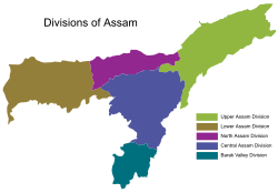
Upper – Assam is an administrative division of the state of Assam comprising the undivided Lakhimpur and Sivasagar districts, of the upper reaches of the Brahmaputra valley. The other divisions are: Lower – Assam, North Assam and Hills and Barak Valley. The division is under the jurisdiction of a Commissioner, stationed at Jorhat.

Lower Assam is a region situated in Western Brahmaputra Valley encompassing undivided Kamrup and Goalpara regions. Soon after the formal creation of the British districts in 1833, Lower Assam denoted one of the five initial districts that were created west of the Dhansiri river, which, along with the six paraganas, became a single district of Kamrup in 1836. It was home to the kingdom of Kamarupa, ruled by Varman's and Pala's from their capital's Pragjyotishpura (Guwahati) and Durjaya. Today Guwahati is the largest city of North-East India while Dispur, the capital of Assam, is within the town.

Undivided Kamrup district is a former administrative district located in Western Assam from which Kamrup Rural (2003), Kamrup Metropolitan (2003), Barpeta (1983), Nalbari (1985) and Baksa (2004) districts were formed. It was announced in January 2020 that the Bajali sub-division of Barpeta district will be upgraded to a full district.

North Assam is an administrative division of Assam under the jurisdiction of a Commissioner, who is officially stationed at Tezpur. It consists of the following districts: Udalguri, Darrang, Sonitpur and Biswanath. Shri Rakesh Kumar, IAS is the current Commissioner of this division.

From the night of 1 May 2014 until the early morning hours of 3 May a series of attacks occurred on the Bengali Muslims in Assam, a north-eastern state of India. The perpetrator is unknown, but is suspected to be the National Democratic Front of Bodoland's Songbijit faction. Speculated to be revenge for not voting for the National Democratic Front in the Lok Sabha elections, the death toll reached 32.

Islam is the second largest religion in Assam. The Muslim population was approximately 14.61 million, constituting over 40.03% of the total population of the state as of 2021 year estimation, making Assam the second-largest Muslim-populated state in the country after Kashmir. Reaching the region in the 13th century, Islam is the fastest-growing religion in Assam. Muslims are a majority in almost thirteen districts of Assam and highly concentrated in four districts.
Assam – 16th largest, 15th most populous and 26th most literate state of the 29 states of the democratic Republic of India. Assam is at 14th position in life expectancy and 8th in female-to-male sex ratio. Assam is the 21st most media exposed states in India. The Economy of Assam is largely agriculture based with 69% of the population engaged in it. Growth rate of Assam's income has not kept pace with that of India's during the Post-British Era; differences increased rapidly since the 1970s. While the Indian economy grew at 6 percent per annum over the period of 1981 to 2000, the same of Assam's grew only by 3.3 percent.

The Miya people (মিঞা), also known as Na-Asamiya, refers to the descendants of migrant Muslims from the modern Mymensingh, Rangpur and Rajshahi Divisions, who settled in the Brahmaputra Valley during the British colonisation of Assam in the 20th-century. Their immigration was encouraged by the Colonial British Government from Bengal Province during 1857 to 1942 and the movement continued till 1947.