Divriği

Last updated • 2 min readFrom Wikipedia, The Free Encyclopedia
Divriği
078 Ulu Cami.Divrigi.jpg
Turkey adm location map.svg
Red pog.svg
Divriği
Location in Turkey
Central Anatolia Region.svg
Red pog.svg
Divriği
Divriği (Turkey Central Anatolia)
Coordinates: 39°22′N38°07′E / 39.367°N 38.117°E / 39.367; 38.117
Country Turkey
Province Sivas
District Divriği
Government
  MayorCihan Deniz Akbaş (CHP)
Population
 (2022) [1]
10,800
Time zone UTC+3 (TRT)
Postal code
58300
Area code 0346
Website www.divrigi.bel.tr

Divriği is a town of eleven thousand people in Sivas Province, Turkey, and is the district capital of Divriği District. [2] [1] The town lies on a gentle slope on the south bank of the Çaltısuyu river, a tributary of the Karasu river which flows into the Euphrates.

Contents

The 13th century Great Mosque and Hospital of Divriği are on UNESCO's World Heritage List by virtue of the exquisite carvings and architecture of both buildings. [3] There are large iron mines nearby and the town is on the Turkish rail network.

History

Great Mosque and Hospital of Divrigi DivrigiUluCami (2006).jpg
Great Mosque and Hospital of Divriği

The Hittites may used the iron ore. [4]

In the 9th century the town was known as Abrik and controlled by the Paulicians with the support of Arabs and the emir of Malatya. [5] It had been founded ca. 850 by Karbeas, the leader of the Paulicians, a heretical Armenian sect that adhered to a dualistic cosmology. The Paulicians fortified it and used it as refuge and the capital of their state during the ninth century. [6]

Later called Tephrike, it was recaptured by the Byzantine Empire during the reign of Emperor Basil I and was temporarily named Leontokome (after Emperor Leo VI) and made into a thema . [6] In the early eleventh century, the town was part of the territory given to the Armenian king Seneqerim-Hovhannes of Vaspurakan in exchange for his lands in Vaspurakan. [6]

After the battle of Manzikert (present day Malazgirt), Divriği came under the control of the Sultanate of Rûm. [7] The Mengüjeks built the Great Mosque and hospital. [5] A medieval castle, with remains mostly from the thirteenth century, is situated on top of a steep hill overlooking the town.

Economy

The railway arrived in 1937 and exports ore from iron mines which still supports the economy of the town and national economy. [5] [8] The Great Mosque and hospital is the main draw, and there are some other places which attract tourists. [9]

Climate

Divriği has a dry-summer continental climate (Köppen: Dsa), bordering a semi-arid climate (Köppen: BSk), [10] with hot, dry summers, and cold, snowy winters. [11]

Climate data for Divriği (1991–2020)
MonthJanFebMarAprMayJunJulAugSepOctNovDecYear
Mean daily maximum °C (°F)2.6
(36.7)
4.6
(40.3)
11.0
(51.8)
17.3
(63.1)
22.5
(72.5)
28.1
(82.6)
32.7
(90.9)
33.2
(91.8)
28.2
(82.8)
21.0
(69.8)
11.9
(53.4)
4.9
(40.8)
18.2
(64.8)
Daily mean °C (°F)−1.6
(29.1)
−0.1
(31.8)
5.5
(41.9)
11.1
(52.0)
15.6
(60.1)
20.4
(68.7)
24.5
(76.1)
24.8
(76.6)
20.1
(68.2)
13.9
(57.0)
6.2
(43.2)
0.7
(33.3)
11.8
(53.2)
Mean daily minimum °C (°F)−5.0
(23.0)
−4.0
(24.8)
0.7
(33.3)
5.4
(41.7)
9.3
(48.7)
13.1
(55.6)
16.5
(61.7)
16.8
(62.2)
12.5
(54.5)
7.8
(46.0)
1.5
(34.7)
−2.5
(27.5)
6.1
(43.0)
Average precipitation mm (inches)33.74
(1.33)
34.26
(1.35)
43.84
(1.73)
69.0
(2.72)
51.4
(2.02)
22.64
(0.89)
8.7
(0.34)
4.86
(0.19)
13.95
(0.55)
34.87
(1.37)
29.55
(1.16)
33.02
(1.30)
379.83
(14.95)
Average precipitation days (≥ 1.0 mm)6.16.47.49.19.24.51.81.72.55.65.07.166.4
Average relative humidity (%)73.069.761.156.356.949.642.341.743.054.865.073.357.2
Source: NOAA [12]

Demographics

About 103 of the 109 villages are populated by Alevis. The majority of the Alevi population is Turkish, with a significant Kurdish Alevi minority. [13] Evliya Çelebi included that Divriği was made up of Greeks and Turkomans as well as Armenians and Kurds in his seyahatname. [14]

Notable people

Related Research Articles

<span class="mw-page-title-main">Sivas Province</span> Province of Turkey

Sivas Province is a province of Turkey. It is located in the eastern part of the Central Anatolia region of Turkey. Its area is 28,164 km2, and its population is 634,924 (2022). Its adjacent provinces are Yozgat to the west, Kayseri to the southwest, Kahramanmaraş to the south, Malatya to the southeast, Erzincan to the east, Giresun to the northeast, and Ordu to the north. Its capital is Sivas.

<span class="mw-page-title-main">Tokat Province</span> Province of Turkey

Tokat Province is a province in northern Turkey. Its area is 10,042 km2, and its population is 596,454 (2022). Its adjacent provinces are Amasya to the northwest, Yozgat to the southwest, Sivas to the southeast, and Ordu to the northeast. Its capital is Tokat, which lies inland of the middle Black Sea region, 422 kilometers from Ankara. The governor is Numan Hatipoğlu, appointed in 2022.

<span class="mw-page-title-main">Tokat</span> Municipality in Turkey

Tokat is a city of Turkey in the mid-Black Sea region of Anatolia. It is the seat of Tokat Province and Tokat District. Its population is 163,405 (2022). It is located at the confluence of the Tokat River with the Yeşilırmak.

<span class="mw-page-title-main">Sivas</span> Municipality in Turkey

Sivas is a city in central Turkey. It is the seat of Sivas Province and Sivas District. Its population is 365,274 (2022).

<span class="mw-page-title-main">Elbistan</span> District and municipality in Kahramanmaraş, Turkey

Elbistan is a municipality and district of Kahramanmaraş Province, Turkey. Its area is 2,201 km2, and its population is 141,307 (2022).

<span class="mw-page-title-main">Kadirli</span> Municipality in Osmaniye, Turkey

Kadirli, historically Kars or Karsbazar, is a city in Osmaniye Province in the Mediterranean region of Turkey. It is the seat of Kadirli District. Its population is 98,469 (2022). It is located in the Çukurova plain, 41 kilometres from the province's capital, Osmaniye. It is located near the ancient site of Flaviopolis.

<span class="mw-page-title-main">Kütahya</span> City in Turkey

Kütahya is a city in western Turkey which lies on the Porsuk River, at 969 metres above sea level. It is the seat of Kütahya Province and Kütahya District. Its population is 263,863 (2022). The region of Kütahya has large areas of gentle slopes with agricultural land culminating in high mountain ridges to the north and west.

<span class="mw-page-title-main">Merzifon</span> Municipality in Amasya, Turkey

Merzifon is a town in Amasya Province in the central Black Sea region of Turkey. It is the seat of Merzifon District. Its population is 61,376 (2021). The mayor is Alp Kargı (CHP).

<span class="mw-page-title-main">Niğde</span> Municipality in Turkey

Niğde is a city and the capital of in the Central Anatolia region of Turkey. It is the seat of Niğde Province and Niğde District. Its population is 170,511 (2022). It lies at an elevation of 1,276 m (4,186 ft).

<span class="mw-page-title-main">Nevşehir</span> Municipality in Turkey

Nevşehir is a city in the Central Anatolia Region of Turkey. It is the seat of Nevşehir Province and Nevşehir District. Its population is 123,882 (2022). It is 290 km (180 mi) from the capital Ankara and lies within the historical region of Cappadocia.

<span class="mw-page-title-main">Battle of Bathys Ryax</span> Battle between the Byzantine Empire and the Paulicians

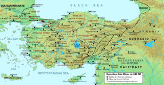
The Battle of Bathys Ryax was fought in 872 or 878 between the Byzantine Empire and the Paulicians. The Paulicians were a Christian sect which—persecuted by the Byzantine state—had established a separate principality at Tephrike on Byzantium's eastern border and collaborated with the Muslim emirates of the Thughur, the Abbasid Caliphate's borderlands, against the Empire. The battle was a decisive Byzantine victory, resulting in the rout of the Paulician army and the death of its leader, Chrysocheir. This event destroyed the power of the Paulician state and removed a major threat to Byzantium, heralding the fall of Tephrike itself and the annexation of the Paulician principality shortly after.

<span class="mw-page-title-main">Muş</span> Municipality in Turkey

Muş is a city in eastern Turkey. It is the seat of Muş Province and Muş District. Its population is 120,699 (2022). Almost all of its population consists of Kurds.

<span class="mw-page-title-main">Yalova</span> Municipality in Turkey

Yalova is a market-gardening town located in northwestern Turkey on the eastern coast of the Sea of Marmara. It is the seat of Yalova Province and Yalova District. Its population is 133,109 (2022). A largely modern town, it is best known for the spa resort at nearby Termal, a popular summer retreat for residents of Istanbul.

<span class="mw-page-title-main">Kemaliye</span> Municipality in Erzincan, Turkey

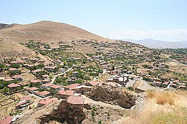
Kemaliye, formerly Eğin, is a town in Erzincan Province in the Eastern Anatolia region of Turkey. It is the seat of Kemaliye District. Its population is 2,536 (2022).

<span class="mw-page-title-main">Belen, Hatay</span> District and municipality in Hatay, Turkey

Belen is a municipality and district of Hatay Province, Turkey. Its area is 184 km2, and its population is 34,449 (2022).

<span class="mw-page-title-main">Divriği Great Mosque and Hospital</span> 13th-century Anatolian beylik-era mosque in central Turkey

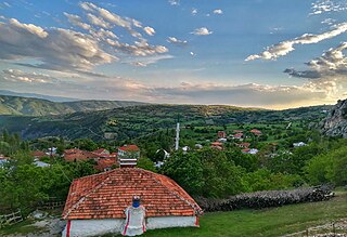
Divriği Great Mosque and Hospital is a mosque and hospital complex built in 1228–1229 by the local dynasty of the Mengujekids in the small Anatolian town of Divriği, now in Sivas Province, Turkey. The complex is located in the upper town, below the citadel. The exquisite stone carvings and eclectic architecture of the complex places it among the most important works of architecture in Anatolia and led to its inclusion on UNESCO's World Heritage List in 1985.

<span class="mw-page-title-main">Turkish art</span>

Turkish art refers to all works of visual art originating from the geographical area of what is present day Turkey since the arrival of the Turks in the Middle Ages. Turkey also was the home of much significant art produced by earlier cultures, including the Hittites, Ancient Greeks, and Byzantines. Ottoman art is therefore the dominant element of Turkish art before the 20th century, although the Seljuks and other earlier Turks also contributed. The 16th and 17th centuries are generally recognized as the finest period for art in the Ottoman Empire, much of it associated with the huge Imperial court. In particular the long reign of Suleiman the Magnificent from 1520 to 1566 brought a combination, rare in any ruling dynasty, of political and military success with strong encouragement of the arts.

Gediz is a town in Kütahya Province in the Aegean region of Turkey. It is the seat of Gediz District. Its population is 26,662 (2022). The town was founded in 1970 after the old town, now called Eskigediz, was destroyed in an earthquake. The old town dates back to ancient times and was historically known as Kadoi in Greek and Gedüs in older Turkish.

<span class="mw-page-title-main">Anatolian Seljuk architecture</span> Architecture associated with the Seljuks of Rum (Anatolia)

Anatolian Seljuk architecture, or simply Seljuk architecture, refers to building activity that took place under the Sultanate of Rum, ruled by an offshoot of the Seljuk dynasty that emerged from the Great Seljuk Empire alongside various other local dynasties. The Anatolian Seljuks patronized their own tradition of architecture whose surviving examples are generally found in present-day Turkey. Anatolian Seljuk architecture was eclectic and influenced by multiple traditions including Armenian, Byzantine, Iranian, and Syrian architecture. Unlike earlier Great Seljuk architecture to the east, their buildings were generally constructed in stone and featured significant stone-carved decoration as well as tile decoration. While the Seljuk Sultanate declined and ended in the late 13th century, architecture continued to flourish and diversify under the smaller Beylik states in Anatolia, which included the early Ottomans.

<span class="mw-page-title-main">Sivas Congress and Ethnography Museum</span>

Sivas Congress and Ethnography Museum is a museum in Sivas, Turkey.

References

  1. 1 2 "Address-based population registration system (ADNKS) results dated 31 December 2022, Favorite Reports" (XLS). TÜİK . Retrieved 22 May 2023.
  2. İlçe Belediyesi, Turkey Civil Administration Departments Inventory. Retrieved 22 May 2023.
  3. "Great Mosque and Hospital of Divriği". UNESCO World Heritage Centre. Retrieved 2019-11-05.
  4. Muhly, J. D.; Maddin, R.; Stech, T.; Özgen, E. (December 1985). "Iron in Anatolia and the Nature of the Hittite Iron Industry". Anatolian Studies. 35: 67–84. doi:10.2307/3642872. ISSN   2048-0849.
  5. 1 2 3 "Divriği Belediye Başkanlığı | Sivas". www.divrigi.bel.tr. Retrieved 2024-10-26.
  6. 1 2 3 Foss, Clive. "Tephrike". Oxford Dictionary of Byzantium . vol. 3. Oxford: Oxford University Press, p. 2025.
  7. Grove Encyclopedia of Islamic Art & Architecture: Three-Volume Set. Oxford University Press.
  8. "Ulusal Tez Merkezi | Anasayfa". tez.yok.gov.tr. Retrieved 2024-10-26.
  9. "Divriği". korumakurullari.ktb.gov.tr. Retrieved 2024-10-26.
  10. "Table 1 Overview of the Köppen-Geiger climate classes including the defining criteria". Nature: Scientific Data.
  11. "Kar Örtülü Gün Sayısı" (PDF). MGM.
  12. "World Meteorological Organization Climate Normals for 1991-2020 — Divriği". National Oceanic and Atmospheric Administration. Retrieved January 14, 2024.
  13. "Divriği hakkında tarihi bilgiler ve Divriği Alevi Köyleri". Alevi Haber (in Turkish). 24 June 2019. Retrieved 26 July 2021.
  14. Evliyâ Çelebi Seyahatnâmesi: III. p. 223. Retrieved 17 October 2022.

Sources