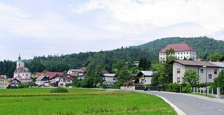
The Municipality of Dobrova–Polhov Gradec is a municipality in Slovenia. The main settlements in the municipality are Dobrova and Polhov Gradec.

Dobrova is a settlement in the City Municipality of Celje in eastern Slovenia. It lies on the northern outskirts of the town of Celje. The area was traditionally part of the Styria region. It is now included in the Savinja Statistical Region.
Dolenja Vas can refer to the following locations:
Anovec is a settlement in the hills northeast of Krško in eastern Slovenia. The area was traditionally part of Lower Carniola. It is now included with the rest of the Municipality of Krško in the Lower Sava Statistical Region.
Anže is a settlement in the hills east of Brestanica in the Municipality of Krško in eastern Slovenia. The area was traditionally part of Lower Carniola. It is now included with the rest of the municipality in the Lower Sava Statistical Region.
Vrbina is a settlement on the right bank of the Sava River in the Municipality of Krško in eastern Slovenia. The Krško Nuclear Power Plant is built on the southern side of the settlement. The area was traditionally part of Lower Carniola. It is now included with the rest of the municipality in the Lower Sava Statistical Region.
Cesta is a settlement in the hills above the right bank of the Sava River in the Municipality of Krško in eastern Slovenia. The area was traditionally part of Lower Carniola. It is now included with the rest of the municipality in the Lower Sava Statistical Region.
Cirje is a settlement south of Raka in the Municipality of Krško in eastern Slovenia. The area was traditionally part of Lower Carniola. It is now included with the rest of the municipality in the Lower Sava Statistical Region.
Dolenji Leskovec is a settlement west of Brestanica in the Municipality of Krško in eastern Slovenia. The area was traditionally part of Styria. It is now included with the rest of the municipality in the Lower Sava Statistical Region.
Drenovec pri Leskovcu is a small settlement west of Leskovec pri Krškem in the Municipality of Krško in eastern Slovenia. The area was traditionally part of Lower Carniola. It is now included with the rest of the municipality in the Lower Sava Statistical Region.
Kališovec is a settlement west of Senovo in the Municipality of Krško in eastern Slovenia. The area was traditionally part of Styria. It is now included with the rest of the municipality in the Lower Sava Statistical Region.
Lokve is a small settlement east of Senovo in the Municipality of Krško in eastern Slovenia. The area was traditionally part of Styria. It is now included with the rest of the municipality in the Lower Sava Statistical Region.
Mrčna Sela is a dispersed settlement in the hills northeast of Senovo in the Municipality of Krško in eastern Slovenia. The area was traditionally part of Styria. It is now included with the rest of the municipality in the Lower Sava Statistical Region.
Slivje is a small settlement on the right bank of the Krka River southwest of Podbočje in the Municipality of Krško in eastern Slovenia. The area was traditionally part of Lower Carniola. It is now included with the rest of the municipality in the Lower Sava Statistical Region.
Smednik is a small settlement south of Raka in the Municipality of Krško in eastern Slovenia. It lies just north of the A2 motorway from Ljubljana to Zagreb. The area was traditionally part of Lower Carniola. It is now included with the rest of the municipality in the Lower Sava Statistical Region.
Spodnje Dule is a settlement in the hills northwest of Leskovec pri Krškem in the Municipality of Krško in eastern Slovenia. The area was traditionally part of Lower Carniola and is now included with the rest of the municipality in the Lower Sava Statistical Region.
Šutna is a settlement east of Podbočje in the Municipality of Krško in eastern Slovenia. The area was traditionally part of Lower Carniola. It is now included with the rest of the municipality in the Lower Sava Statistical Region.
Dobrova pri Prihovi is a small settlement in the Municipality of Oplotnica in eastern Slovenia. Traditionally the area was part of the Styria region. It is now included in the Drava Statistical Region.


