
Brestanica is an urban settlement in the Municipality of Krško in eastern Slovenia. It lies in the valley at the confluence of the Sava River with a minor tributary called the Brestanica. The area is part of the traditional region of Styria. It is now included with the rest of the municipality in the Lower Sava Statistical Region.
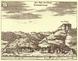
Krško Castle is a 12th-century castle ruin to the right of the Sava above the old center of the town of Krško, southeastern Slovenia. It stands in the territory of the settlement of Cesta. The castle and town are both named after the nearby Krka River.

Leskovec pri Krškem is a settlement on the right bank of the Sava River in the City Municipality of Krško in eastern Slovenia. The area is part of the traditional region of Lower Carniola. It is now included with the rest of the municipality in the Lower Sava Statistical Region. It includes the hamlets of Grad, Beli Breg, Veliki Marof, and Žadovinka. Older sources also mention the appertaining hamlet of Bajer.
Vrbina is a settlement on the right bank of the Sava River in the Municipality of Krško in eastern Slovenia. The Krško Nuclear Power Plant is built on the southern side of the settlement. The area is part of the traditional region of Lower Carniola. It is now included with the rest of the municipality in the Lower Sava Statistical Region.
Cesta is a settlement in the hills above the right bank of the Sava River in the Municipality of Krško in eastern Slovenia. The area is part of the traditional region of Lower Carniola. It is now included with the rest of the municipality in the Lower Sava Statistical Region.
Dalce is a small settlement in the hills above the right bank of the Sava River in the Municipality of Krško in eastern Slovenia. The area is part of the traditional region of Lower Carniola. It is now included with the rest of the municipality in the Lower Sava Statistical Region.
Gunte is a small settlement in the hills above the right bank of the Sava River in the Municipality of Krško in eastern Slovenia. The area is part of the traditional region of Lower Carniola. It is now included with the rest of the municipality in the Lower Sava Statistical Region.
Kalce–Naklo is a village in the flat plains between the Sava and Krka rivers, south of Leskovec pri Krškem in the Municipality of Krško in eastern Slovenia. As its compound name suggests, it is made up of two parts: Kalce to the north and Naklo to the south. The area is part of the traditional region of Lower Carniola. It is now included with the rest of the municipality in the Lower Sava Statistical Region.
Pesje is a settlement on the left bank of the Sava River in the Municipality of Krško in eastern Slovenia. The area is part of the traditional region of Lower Carniola. It is now included with the rest of the municipality in the Lower Sava Statistical Region.
Spodnje Pijavško is a settlement on the right bank of the Sava River in the Municipality of Krško in eastern Slovenia. The area is part of the traditional region of Lower Carniola and is now included with the rest of the municipality in the Lower Sava Statistical Region.
Stari Grad v Podbočju is a settlement south of Podbočje in the Municipality of Krško in eastern Slovenia. The area is part of the traditional region of Lower Carniola and is now included with the rest of the municipality in the Lower Sava Statistical Region.
Stari Grad is a settlement east of the town of Krško in eastern Slovenia. The area is part of the traditional region of Styria. It is now included with the rest of the municipality in the Lower Sava Statistical Region.
Stolovnik is a dispersed settlement east of Brestanica in the Municipality of Krško in eastern Slovenia. The area is part of the traditional region of Styria. It is now included with the rest of the municipality in the Lower Sava Statistical Region.
Strmo Rebro is a small settlement in the hills above the right bank of the Sava River, northwest of Gora in the Municipality of Krško in eastern Slovenia. The area is part of the traditional region of Lower Carniola. It is now included with the rest of the municipality in the Lower Sava Statistical Region.

Spodnji Hotič is a settlement on the left bank of the Sava River north of Litija in central Slovenia. The area is part of the traditional region of Upper Carniola and is now included with the rest of the Municipality of Litija in the Central Sava Statistical Region.

Spodnji Log is a village on the right bank of the Sava River in the Municipality of Litija in central Slovenia. The area is included with the rest of the municipality in the Central Sava Statistical Region. Traditionally, it was part of the Lower Carniola region.

Spodnji Prekar is a small settlement in the hills above the left bank of the Sava River in the Municipality of Moravče in central Slovenia. The area is part of the traditional region of Upper Carniola. It is now included with the rest of the municipality in the Central Slovenia Statistical Region.
The Urban Municipality of Krško is an urban municipality in eastern Slovenia. Its seat is the town of Krško. The area is traditionally divided between Lower Styria and Lower Carniola. The entire municipality is now included in the Lower Sava Statistical Region. Krško received the status of an urban municipality in December 2021. It borders Croatia.

The Urban Municipality of Slovenj Gradec is a municipality in northern Slovenia. The seat of the municipality is the town of Slovenj Gradec. It is part of the historic Styria region, and since 2005 it has belonged to the NUTS-3 Carinthia Statistical Region.
Spodnji Šemnik is a small settlement in the Municipality of Zagorje ob Savi in central Slovenia. The settlement is part of the traditional region of the Upper Carniola and is included in the Central Sava Statistical Region.

