Ravno, Krško

Last updated
Ravno
Slovenia location map.svg
Red pog.svg
Ravno
Location in Slovenia
Coordinates: 45°53′50.11″N15°22′27.68″E / 45.8972528°N 15.3743556°E / 45.8972528; 15.3743556 Coordinates: 45°53′50.11″N15°22′27.68″E / 45.8972528°N 15.3743556°E / 45.8972528; 15.3743556
Country Flag of Slovenia.svg Slovenia
Traditional region Lower Carniola
Statistical region Lower Sava
Municipality Krško
Area
  Total 1.1 km2 (0.4 sq mi)
Elevation 159.5 m (523.3 ft)
Population (2002)
  Total 80
[1]

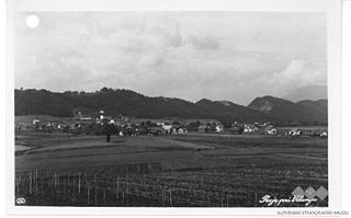
Ravno (pronounced  [ˈɾaːu̯nɔ] ; German : Rauno [2] ) is a settlement in the Municipality of Krško in eastern Slovenia. The area was traditionally part of Lower Carniola. It is now included in the Lower Sava Statistical Region. [3]

German language West Germanic language

German is a West Germanic language that is mainly spoken in Central Europe. It is the most widely spoken and official or co-official language in Germany, Austria, Switzerland, South Tyrol (Italy), the German-speaking Community of Belgium, and Liechtenstein. It is also one of the three official languages of Luxembourg and a co-official language in the Opole Voivodeship in Poland. The languages which are most similar to German are the other members of the West Germanic language branch: Afrikaans, Dutch, English, the Frisian languages, Low German/Low Saxon, Luxembourgish, and Yiddish. There are also strong similarities in vocabulary with Danish, Norwegian and Swedish, although those belong to the North Germanic group. German is the second most widely spoken Germanic language, after English.

Municipality of Krško Municipality in Slovenia

The Municipality of Krško is a municipality in eastern Slovenia. Its seat is the town of Krško. The area is traditionally divided between Lower Styria and Lower Carniola. The entire municipality is now included in the Lower Sava statistical region.

Slovenia republic in Central Europe

Slovenia, officially the Republic of Slovenia, is a sovereign state located in southern Central Europe at a crossroads of important European cultural and trade routes. It is bordered by Italy to the west, Austria to the north, Hungary to the northeast, Croatia to the southeast, and the Adriatic Sea to the southwest. It covers 20,273 square kilometers (7,827 sq mi) and has a population of 2.07 million. One of the successor states of the former Yugoslavia, Slovenia is a parliamentary republic and a member of the United Nations, of the European Union, and of NATO. The capital and largest city is Ljubljana.

The local church, built on a small hill in the northern part of the settlement known as Gornje Ravno, is dedicated to Saint Leonard and belongs to the Parish of Raka. It is a Baroque building dating to the 17th century. [4]

Church (building) building constructed for Christian worship

A church building or church house, often simply called a church, is a building used for Christian religious activities, particularly for Christian worship services. The term is often used by Christians to refer to the physical buildings where they worship, but it is sometimes used to refer to buildings of other religions. In traditional Christian architecture, the church is often arranged in the shape of a Christian cross. When viewed from plan view the longest part of a cross is represented by the aisle and the junction of the cross is located at the altar area.

Leonard of Noblac Frankish saint

Leonard of Noblac, is a Frankish saint closely associated with the town and abbey of Saint-Léonard-de-Noblat, in Haute-Vienne, in the Limousin (region) of France.

A parish is a territorial entity in many Christian denominations, constituting a division within a diocese. A parish is under the pastoral care and clerical jurisdiction of a parish priest, who might be assisted by one or more curates, and who operates from a parish church. Historically, a parish often covered the same geographical area as a manor. Its association with the parish church remains paramount.

Related Research Articles

Anovec in Lower Carniola, Slovenia

Anovec is a settlement in the hills northeast of Krško in eastern Slovenia. The area was traditionally part of Lower Carniola. It is now included with the rest of the Municipality of Krško in the Lower Sava Statistical Region.

Anže, Krško Place in Lower Carniola, Slovenia

Anže is a settlement in the hills east of Brestanica in the Municipality of Krško in eastern Slovenia. The area was traditionally part of Lower Carniola. It is now included with the rest of the municipality in the Lower Sava Statistical Region.

Apnenik pri Velikem Trnu in Lower Carniola, Slovenia

Apnenik pri Velikem Trnu is a settlement in the hills east of Krško in eastern Slovenia. The area was traditionally part of Lower Carniola. It is now included with the rest of the municipality in the Lower Sava Statistical Region.

Ženje in Lower Carniola, Slovenia

Ženje is a small settlement in the hills above the right bank of the Sava River in the Municipality of Krško in eastern Slovenia. The area was traditionally part of Lower Carniola. It is now included in the Lower Sava Statistical Region.

Dobrava pod Rako in Lower Carniola, Slovenia

Dobrava pod Rako is a small settlement to the south of Raka in the Municipality of Krško in eastern Slovenia. The area was traditionally part of Lower Carniola. It is now included in the Lower Sava Statistical Region.

Ravni, Krško in Lower Carniola, Slovenia

Ravni is a village in the Municipality of Krško in eastern Slovenia. The area was traditionally part of Lower Carniola. It is now included with the rest of the municipality in the Lower Sava Statistical Region.

Vrbina Place in Lower Carniola, Slovenia

Vrbina is a settlement on the right bank of the Sava River in the Municipality of Krško in eastern Slovenia. The Krško Nuclear Power Plant is built on the southern side of the settlement. The area was traditionally part of Lower Carniola. It is now included with the rest of the municipality in the Lower Sava Statistical Region.

Cesta, Krško in Lower Carniola, Slovenia

Cesta is a settlement in the hills above the right bank of the Sava River in the Municipality of Krško in eastern Slovenia. The area was traditionally part of Lower Carniola. It is now included with the rest of the municipality in the Lower Sava Statistical Region.

Gmajna, Krško in Lower Carniola, Slovenia

Gmajna is a settlement in the Municipality of Krško in eastern Slovenia. The A2 motorway from Ljubljana to Zagreb runs through the territory of Gmajna. The area was traditionally part of Lower Carniola. It is now included in the Lower Sava Statistical Region.

Golek, Krško in Lower Carniola, Slovenia

Golek is a settlement in the hills northwest of Leskovec pri Krškem in the Municipality of Krško in eastern Slovenia. The area was traditionally part of Lower Carniola. It is now included in the Lower Sava Statistical Region.

Hrastek in Lower Carniola, Slovenia

Hrastek is a small settlement in the Gorjanci Hills in the Municipality of Krško in eastern Slovenia. The area was traditionally part of Lower Carniola. It is now included with the rest of the municipality in the Lower Sava Statistical Region.

Pesje Village in Styria, Slovenia

Pesje is a settlement on the left bank of the Sava River in the Municipality of Krško in eastern Slovenia. The area was traditionally part of Lower Carniola. It is now included with the rest of the municipality in the Lower Sava Statistical Region.

Premagovce in Lower Carniola, Slovenia

Premagovce is a settlement in the Gorjanci Hills in the Municipality of Krško in eastern Slovenia, right on the border with Croatia. The area was traditionally part of Lower Carniola. It is now included in the Lower Sava Statistical Region.

Sela pri Raki in Lower Carniola, Slovenia

Sela pri Raki is a settlement southeast of Raka in the Municipality of Krško in eastern Slovenia. The area was traditionally part of Lower Carniola. It is now included in the Lower Sava Statistical Region.

Selce pri Leskovcu in Lower Carniola, Slovenia

Selce pri Leskovcu is a small settlement west of Leskovec pri Krškem in the Municipality of Krško in eastern Slovenia. The area was traditionally part of Lower Carniola. It is now included in the Lower Sava Statistical Region.

Smečice Place in Lower Carniola, Slovenia

Smečice is a small settlement in the hills west of Krško in eastern Slovenia. The area was traditionally part of Lower Carniola. It is now included with the rest of the municipality in the Lower Sava Statistical Region.

Smednik in Lower Carniola, Slovenia

Smednik is a small settlement south of Raka in the Municipality of Krško in eastern Slovenia. It lies just north of the A2 motorway from Ljubljana to Zagreb. The area was traditionally part of Lower Carniola. It is now included with the rest of the municipality in the Lower Sava Statistical Region.

Šutna, Krško Place in Lower Carniola, Slovenia

Šutna is a settlement east of Podbočje in the Municipality of Krško in eastern Slovenia. The area was traditionally part of Lower Carniola. It is now included with the rest of the municipality in the Lower Sava Statistical Region.

Ravno Brdo Place in Lower Carniola, Slovenia

Ravno Brdo is a dispersed settlement in the hills east of Ljubljana in Slovenia. It belongs to the City Municipality of Ljubljana. It was part of the traditional region of Lower Carniola and is now included with the rest of the municipality in the Central Slovenia Statistical Region.

Ravno, Dobje Place in Styria, Slovenia

Ravno is a small village in the Municipality of Dobje in eastern Slovenia. The area was traditionally part of Styria and is now included with the rest of the municipality in the Savinja Statistical Region.

References

  1. Statistical Office of the Republic of Slovenia
  2. Leksikon občin kraljestev in dežel zastopanih v državnem zboru, vol. 6: Kranjsko. 1906. Vienna: C. Kr. Dvorna in Državna Tiskarna, p. 78.
  3. Krško municipal site
  4. Slovenian Ministry of Culture register of national heritage reference number 2208