Dobroviš

Last updated
Dobroviš
Village
Serbia adm location map.svg
Red pog.svg
Dobroviš
Coordinates: 42°57′08″N22°21′25″E / 42.95222°N 22.35694°E / 42.95222; 22.35694
CountryFlag of Serbia.svg  Serbia
District Jablanica District
Municipality Vlasotince
Population (2002)
  Total 141
Time zone CET (UTC+1)
  Summer (DST) CEST (UTC+2)

Dobroviš is a village in the municipality of Vlasotince, Serbia. According to the 2002 census, the village has a population of 141 people. [1]

Village Small clustered human settlement smaller than a town

A village is a clustered human settlement or community, larger than a hamlet but smaller than a town, with a population ranging from a few hundred to a few thousand. Though villages are often located in rural areas, the term urban village is also applied to certain urban neighborhoods. Villages are normally permanent, with fixed dwellings; however, transient villages can occur. Further, the dwellings of a village are fairly close to one another, not scattered broadly over the landscape, as a dispersed settlement.

Vlasotince Town and municipality in Southern and Eastern Serbia, Serbia

Vlasotince is a town and municipality located in Jablanica District of southern Serbia. As of 2011, the municipality has 29,669 inhabitants, while the town itself has a population of 15,830 inhabitants.

Serbia Republic in Southeastern Europe

Serbia, officially the Republic of Serbia, is a country situated at the crossroads of Central and Southeast Europe in the southern Pannonian Plain and the central Balkans. The sovereign state borders Hungary to the north, Romania to the northeast, Bulgaria to the southeast, North Macedonia to the south, Croatia and Bosnia and Herzegovina to the west, and Montenegro to the southwest. The country claims a border with Albania through the disputed territory of Kosovo. Serbia's population is about seven million. Its capital, Belgrade, ranks among the oldest and largest citiеs in southeastern Europe.

Related Research Articles

Kaloyanovo Municipality is a municipality in the Plovdiv Province, central Bulgaria and covers an area of 347 km². As of 2006 it has 12,390 inhabitants. The center of the municipality is the village of Kaloyanovo.

Tsovagyugh Place in Gegharkunik, Armenia

Tsovagyugh, is a major village in the Gegharkunik Province of Armenia. The ruins of a church are in the village, and upon an egg-shaped hill to the northeast are the remains of an Iron Age fort.

Mijnatun Place in Aragatsotn Province, Armenia

Mijnatun ; formerly known as Ortachya, is a village in the Aragatsotn Province of Armenia. It is mostly populated by Yazidis.

Karsibór, Wałcz County Village in West Pomeranian, Poland

Karsibór is a village in the administrative district of Gmina Wałcz, within Wałcz County, West Pomeranian Voivodeship, in north-western Poland. It lies approximately 11 kilometres (7 mi) north of Wałcz and 122 km (76 mi) east of the regional capital Szczecin.

Starzynka is a village in the administrative district of Gmina Sokółka, within Sokółka County, Podlaskie Voivodeship, in north-eastern Poland, close to the border with Belarus.

Çıraq Place in Kalbajar, Azerbaijan

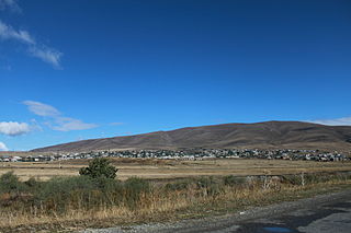
Çıraq is a village in the Kalbajar Rayon of Azerbaijan.

Jadwigów, Opatów County Village in Świętokrzyskie, Poland

Jadwigów is a village in the administrative district of Gmina Tarłów, within Opatów County, Świętokrzyskie Voivodeship, in south-central Poland. It lies approximately 6 kilometres (4 mi) south of Tarłów, 27 km (17 mi) north-east of Opatów, and 78 km (48 mi) east of the regional capital Kielce.

Kępa Radwankowska Village in Masovian, Poland

Kępa Radwankowska is a village in the administrative district of Gmina Góra Kalwaria, within Piaseczno County, Masovian Voivodeship, in east-central Poland. It lies approximately 5 kilometres (3 mi) south-east of Góra Kalwaria, 22 km (14 mi) south-east of Piaseczno, and 35 km (22 mi) south-east of Warsaw.

Patrykozy-Kolonia is a village in the administrative district of Gmina Bielany, within Sokołów County, Masovian Voivodeship, in east-central Poland.

Jhimpe is a village development committee in Salyan District in the Rapti Zone of western-central Nepal. At the time of the 1991 Nepal census it had a population of 5727 people living in 908 individual households.

Stróżewko, Greater Poland Voivodeship Village in Greater Poland, Poland

Stróżewko is a village in the administrative district of Gmina Chodzież, within Chodzież County, Greater Poland Voivodeship, in west-central Poland. It lies approximately 4 kilometres (2 mi) south of Chodzież and 62 km (39 mi) north of the regional capital Poznań.

Romanowo is a village in the administrative district of Gmina Sompolno, within Konin County, Greater Poland Voivodeship, in west-central Poland.

Adamowo is a village in the administrative district of Gmina Susz, within Iława County, Warmian-Masurian Voivodeship, in northern Poland.

Smrdan (Leskovac) Village in Jablanica District, Serbia

Smrdan is a village in the municipality of Leskovac, Serbia. According to the 2002 census, the village has a population of 155 people.

Brezovica, Vlasotince Village in Jablanica District, Serbia

Brezovica is a village in the municipality of Vlasotince, Serbia. According to the 2002 census, the village has a population of 165 people.

Orašje (Vlasotince) Village in Jablanica District, Serbia

Orašje is a village in the municipality of Vlasotince, Serbia. According to the 2002 census, the village has a population of 934 people.

Velika Jasikova Village in Zaječar District, Serbia

Velika Jasikova is a village in the municipality of Zaječar, Serbia. According to the 2011 census, the village has a population of 802 people.

Kõrve is a village in Mustvee Parish, Jõgeva County in northeastern Estonia.

Brejakovići Village in Republika Srpska, Bosnia and Herzegovina

Brejakovići is a village in the municipality of Sokolac, Bosnia and Herzegovina.

Ahmad Gharib is a village in Lahijan-e Sharqi Rural District, Lajan District, Piranshahr County, West Azerbaijan Province, Iran. At the 2006 census, its population was 88, in 10 families.

References

  1. Popis stanovništva, domaćinstava i Stanova 2002. Knjiga 1: Nacionalna ili etnička pripadnost po naseljima. Republika Srbija, Republički zavod za statistiku Beograd 2003. ISBN   86-84433-00-9

Coordinates: 42°57′08″N22°21′25″E / 42.95222°N 22.35694°E / 42.95222; 22.35694

Geographic coordinate system Coordinate system

A geographic coordinate system is a coordinate system that enables every location on Earth to be specified by a set of numbers, letters or symbols. The coordinates are often chosen such that one of the numbers represents a vertical position and two or three of the numbers represent a horizontal position; alternatively, a geographic position may be expressed in a combined three-dimensional Cartesian vector. A common choice of coordinates is latitude, longitude and elevation. To specify a location on a plane requires a map projection.