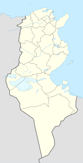
La Goulette is the port of Tunis, the capital of Tunisia. The Kasbah fortress was built in 1535 by Charles I of Spain but was captured by the Ottoman Turks in 1574. La Goulette is located at around 36°49′5″N10°18′18″E.
Baranówka is the part of Śniadków Górny A village, Gmina Sobienie-Jeziory. From 1975 to 1998 this place was in Siedlce Voivodeship.

Dąbrowa is a village in the administrative district of Gmina Przesmyki, within Siedlce County, Masovian Voivodeship, in east-central Poland. It lies approximately 6 kilometres (4 mi) north-east of Przesmyki, 29 km (18 mi) north-east of Siedlce, and 112 km (70 mi) east of Warsaw.
Łakno is a village in the administrative district of Gmina Chodecz, within Włocławek County, Kuyavian-Pomeranian Voivodeship, in north-central Poland.

Almalı is a village in the Khojali Rayon of Azerbaijan. Since the Nagorno-Karabakh war the village has been administered by the de facto independent Republic of Artsakh as part of Askeran Region.
Dərəkənd is a village in the Khojavend Rayon of Azerbaijan.
Qarabağlı is a former village in the Şabran Rayon of Azerbaijan.
Doleck is a village in the administrative district of Gmina Nowy Kawęczyn, within Skierniewice County, Łódź Voivodeship, in central Poland. It lies approximately 5 kilometres (3 mi) north-east of Nowy Kawęczyn, 13 km (8 mi) south-east of Skierniewice, and 60 km (37 mi) east of the regional capital Łódź.
Kamyszów is a village in the administrative district of Gmina Kazimierza Wielka, within Kazimierza County, Świętokrzyskie Voivodeship, in south-central Poland. It lies approximately 4 kilometres (2 mi) north of Kazimierza Wielka and 65 km (40 mi) south of the regional capital Kielce.

Lipie is a village in the administrative district of Gmina Czarna, within Bieszczady County, Subcarpathian Voivodeship, in south-eastern Poland, close to the border with Ukraine. It lies approximately 4 kilometres (2 mi) south-east of Czarna, 17 km (11 mi) south-east of Ustrzyki Dolne, and 96 km (60 mi) south-east of the regional capital Rzeszów.
Dmochy-Rętki is a village in the administrative district of Gmina Bielany, within Sokołów County, Masovian Voivodeship, in east-central Poland.
Bierzglinek is a village in the administrative district of Gmina Września, within Września County, Greater Poland Voivodeship, in west-central Poland. It lies approximately 4 kilometres (2 mi) south of Września and 46 km (29 mi) east of the regional capital Poznań.
Bystra is a village in the administrative district of Gmina Pruszcz Gdański, within Gdańsk County, Pomeranian Voivodeship, in northern Poland. It lies approximately 10 kilometres (6 mi) north-east of Pruszcz Gdański and 11 km (7 mi) south-east of the regional capital Gdańsk.
Anzourou is a village and rural commune in Niger.

Tmava is a village in the municipality of Kuršumlija, Serbia. According to the 2002 census, the village has a population of 199 people.
Ravni Del is a village in the municipality of Vlasotince, Serbia. According to the 2002 census, the village has a population of 183 people.
Puig de l'Obiol is a mountain of Catalonia, Spain. It has an elevation of 1,543 metres above sea level.
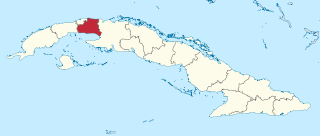
Mayabeque Province is one of two new provinces created from the former La Habana Province, whose creation was approved by the Cuban National Assembly on August 1, 2010, the other being Artemisa Province. The new provinces were enforced on January 1, 2011.

Hongshuwan station is a metro station on Line 2 of the Shenzhen Metro. It was opened on 28 December 2010.
Galičani is a village in Municipality of Prilep, Republic of Macedonia. It is best known for its farming, with the production of tobacco, various fruits including plums, peaches, grapes and watermelon and vegetables such as potato, pumpkin and beans.


