
Dumbría is a municipality of northwestern Spain in the province of A Coruña, in the autonomous community of Galicia. It belongs to the comarca of Finisterre. It had a population of 3,652 inhabitants in 2011.
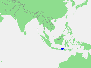
The Bali Sea is the body of water north of the island of Bali and south of Kangean Island in Indonesia. The sea forms the south-west part of the Flores Sea, and the Madura Strait opens into it from the west.

Gostinu is a commune located in Giurgiu County, Romania. It is composed of a single village, Gostinu.

Niemojki is a village in the administrative district of Gmina Łosice, within Łosice County, Masovian Voivodeship, in east-central Poland. It lies approximately 6 kilometres (4 mi) north of Łosice and 117 km (73 mi) east of Warsaw.

The Sićevo Gorge, a river gorge and archaeological site in southeastern Serbia is the locally most prominent geological and topographic feature formed by the Nišava River. The gorge is located between the towns of Bela Palanka and Niška Banja. It is 17 km (11 mi) long and 350 to 400 m deep, in some parts developing canyon-like structures. The gorge is cut into the Kunovica plateau, between the southern slopes of the Svrljig Mountains and the mountain of Suva Planina. The surrounding areas are known for their high-quality vineyards. The gorge contains a stone quarry, the Ostrovica and six villages. The largest, Sićevo is the eponym of the gorge.

Dragojevac is a village in the municipality of Arilje, Serbia. According to the 2011 census, the village has a population of 264 people.
Drćevac is a village in the municipality of Leskovac, Serbia. According to the 2002 census, the village has a population of 309 people.
Jarsenovo is a village in the municipality of Leskovac, Serbia. According to the 2002 census, the village has a population of 428 people.

Manojlovce is a village in the municipality of Leskovac, Serbia. According to the 2002 census, the village has a population of 778 people.
Oraovica is a village in the municipality of Leskovac, Serbia. According to the 2002 census, the village has a population of 152 people.

Rajno Polje is a village in the municipality of Leskovac, Serbia. According to the 2002 census, the village has a population of 739 people.
Donja Lomnica is a village in the municipality of Vlasotince, Serbia. According to the 2002 census, the village has a population of 591 people.
Svrljiška Topla is a village in the municipality of Knjaževac, Serbia. According to the 2002 census, the village has a population of 112 people.
Rehemäe is a village in Lääne-Nigula Parish, Lääne County in western Estonia.
Strojinci is a village in the municipality of Brus, Serbia. According to the 2002 census, the village has a population of 493 people.
Jelen Do is a village in the municipality of Požega, western Serbia. According to the 2002 census, the village has a population of 167 people.
Štavalj is a village in the municipality of Sjenica, Serbia. According to the 2002 census, the village has a population of 312 people.
Tuzinje is a village in the municipality of Sjenica, Serbia. According to the 2002 census, the village has a population of 204 people.
Kućane is a village in the municipality of Raška, Serbia. According to the 2002 census, the village has a population of 117 people.
Vrtine is a village in the municipality of Raška, Serbia. According to the 2002 census, the village has a population of 117 people.


