
Bei River is the northern tributary of the Pearl River in southern China. The other two main tributaries of the Pearl River are the Xijiang River and the Dongjiang River.
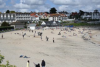
Gyllyngvase is one of the four beaches associated with Falmouth, Cornwall, United Kingdom, south of Pendennis Castle.

Achajur is a village in the Tavush province of Armenia.
Zagradje is a small municipality in south Montenegro and is close to the town of Sutomore. It is renowned for its air quality and beaches.
Zakale is a village in the administrative district of Gmina Korycin, within Sokółka County, Podlaskie Voivodeship, in north-eastern Poland.

Birinci Yüzbaşılı is a village in the Agdam Rayon of Azerbaijan. The village forms part of the municipality of Xındırıstan.
Qoçbəyli is a village in the Fizuli Rayon of Azerbaijan.
Keşdək is a village in the Kalbajar Rayon of Azerbaijan.

Dobryszyce is a village in Radomsko County, Łódź Voivodeship, in central Poland. It is the seat of the gmina called Gmina Dobryszyce. It lies approximately 10 kilometres (6 mi) north of Radomsko and 71 km (44 mi) south of the regional capital Łódź.
Zdziesławice is a village in the administrative district of Gmina Michałowice, within Kraków County, Lesser Poland Voivodeship, in southern Poland. It lies approximately 12 km (7 mi) north-east of the regional capital Kraków.
Pustków-Krownice is a village in the administrative district of Gmina Dębica, within Dębica County, Subcarpathian Voivodeship, in south-eastern Poland. It lies approximately 14 kilometres (9 mi) north-east of Dębica and 37 km (23 mi) west of the regional capital Rzeszów.
Zalesie is a village in the administrative district of Gmina Zagórów, within Słupca County, Greater Poland Voivodeship, in west-central Poland. It lies approximately 4 kilometres (2 mi) south-east of Zagórów, 18 km (11 mi) south of Słupca, and 75 km (47 mi) east of the regional capital Poznań.
Buczkowice is a village in Bielsko County, Silesian Voivodeship, in southern Poland. It is the seat of the gmina called Gmina Buczkowice. It lies approximately 12 kilometres (7 mi) south of Bielsko-Biała and 59 km (37 mi) south of the regional capital Katowice.
Grochowo Pierwsze is a village in the administrative district of Gmina Sztutowo, within Nowy Dwór Gdański County, Pomeranian Voivodeship, in northern Poland. It lies approximately 4 kilometres (2 mi) south-west of Sztutowo, 10 km (6 mi) north of Nowy Dwór Gdański, and 35 km (22 mi) east of the regional capital Gdańsk.
Korytowo is a village in the administrative district of Gmina Choszczno, within Choszczno County, West Pomeranian Voivodeship, in north-western Poland. It lies approximately 11 kilometres (7 mi) east of Choszczno (Arnswalde) and 71 km (44 mi) south-east of the regional capital Szczecin (Stettin).
Płoki is a village in the administrative district of Gmina Choszczno, within Choszczno County, West Pomeranian Voivodeship, in north-western Poland. It lies approximately 3 kilometres (2 mi) south of Choszczno and 63 km (39 mi) south-east of the regional capital Szczecin.
Niekłonice is a village in the administrative district of Gmina Świeszyno, within Koszalin County, West Pomeranian Voivodeship, in north-western Poland. It lies approximately 5 kilometres (3 mi) north of Świeszyno, 4 km (2 mi) south-west of Koszalin, and 132 km (82 mi) north-east of the regional capital Szczecin.
Nová Ves I is a village and municipality in Kolín District in the Central Bohemian Region of the Czech Republic.
Hoffman, New York is a hamlet in the towns of Pendleton and Wheatfield in Niagara County, New York, United States.

Ravni Do is a village situated in Niška Banja municipality in Serbia.


