Dock Creek

Last updated
The former course of Dock Creek and its tributaries Dock Creek.png
The former course of Dock Creek and its tributaries

Dock Creek was a stream draining much of what is now the eastern half of Center City, Philadelphia. It was a tributary of the Delaware River. By 1820, the entire creek had been covered and converted to a sewer. The present-day Dock Street follows the lower course of the stream.

Contents

Course

Called Cooconocon by the native Lenape people, Dock Creek was near the center of William Penn's initial settlement in Philadelphia. [1] [2] The area around the mouth of the creek was marshy, and early Philadelphians referred to it as "The Swamp". [1] The creek's source was near present-day Eleventh Street between Arch and Race. [3] It then flowed through a pond around present-day Fifth and Market streets, after which it flowed south and east. [2] At about Fourth and Chestnut, it was joined by another small stream, Munday's Run. [2] Dock Creek then ran southeast, where it was joined by the Little Dock Creek, and through the swamp to the Delaware River. [2]

Colonial history

Penn thought the mouth of the Dock a good site to dock ships, giving rise to the name. He declared that the area should be a harbor forever, but later inhabitants did not follow his plan. [1] By 1704, a drawbridge was constructed near the mouth of the creek, the first bridge in the colony of Pennsylvania. [1] More bridges followed: at Second Street in 1713, Third Street in 1740, and Walnut Street in 1767. [1] In 1763, the creek's use as an open sewer led residents to describe it as "a Receptacle for the Carcasses of dead Dogs, and other Carrion, and Filth of various kinds, which laying exposed to the Sun and Air putrify and become extremely offensive and injurious to the Health of the Inhabitants." [4] Increased development in the area led settlers to cover the creek above Second Street by 1769. [5] By 1784, it was covered all the way to its outlet at the Delaware. [5]

Conversion to sewer

The mouth of the Dock had become known as "a foul place, especially when the tide was out." [3] The stream became completely buried and served as a sewer for the neighborhood. By the 1840s, the sewer had become inadequate and frequently overflowed into the streets above. [6] Investigators recommended that Philadelphia City Council build a culvert under the streets to carry the stream, which they did. By the 1870s, the Dock Street Market was the city's primary's wholesale produce distribution center until its closure in 1959.

During urban renewal in the 1960s, new sewer lines were constructed in the area, and archaeologists investigated the former site of the city's main waterfront. [7] An art project in 2008 through Philadelphia's FringeArts Festival investigated the former course of Dock Creek between Third and Fifth streets, in what is now Independence National Historical Park. [8]

Notes

  1. 1 2 3 4 5 Philadelphia Times 1889.
  2. 1 2 3 4 PLA 1879, p. 5.
  3. 1 2 Kite 1895, pp. 264–265.
  4. Olton 1974, p. 92.
  5. 1 2 Cotter 1992, p. 235.
  6. Topo 1849.
  7. Cotter 1992, p. 236.
  8. Lutz 2008.

Related Research Articles

Lenapehoking

Lenapehoking is widely translated as 'homelands of the Lenape', which in the 16th and 17th centuries, ranged along the Atlantic's coast from western Connecticut to Delaware, and encompassed the territory adjacent to the Delaware and lower Hudson river valleys, as well as the territory between them. It historically accommodated the colonies of New Sweden and New Netherlands, but by the early 18th century the expansion of English colonies had depopulated or displaced most surviving tribal peoples. The US federal government also forcibly displaced the Lenape through Indian removal policies to Ontario and the Midwestern United States, and on to what is now Oklahoma, where they are the Delaware Nation and Delaware Tribe of Indians.

Brandywine Creek (Christina River tributary) Creek in Pennsylvania and Delaware, US

Brandywine Creek is a tributary of the Christina River in southeastern Pennsylvania and northern Delaware in the United States. The Lower Brandywine is 20.4 miles (32.8 km) long and is a designated Pennsylvania Scenic River with several tributary streams. The East Branch and West Branch of the creek originate within 2 miles (3 km) of each other on the slopes of Welsh Mountain in Honey Brook Township, Pennsylvania, about 20 miles (32 km) northwest of their confluence.

Darby Creek (Pennsylvania) Creek in Pennsylvania, USA

Darby Creek is a tributary of the Delaware River in Chester, Delaware and Philadelphia counties, in the U.S. Commonwealth of Pennsylvania. It is approximately 26 miles (42 km) long. The watershed of the creek has an area of 77.2 square miles (200 km2). It has twelve named direct tributaries, including Cobbs Creek, Little Darby Creek, Ithan Creek, and Muckinipattis Creek. The creek has a low level of water quality for most of its length. The lower Darby Creek area was deemed a Superfund site by the U.S. Environmental Protection Agency (EPA) due to contamination with dangerous chemicals from two landfills.

Cobbs Creek

Cobbs Creek is an 11.8-mile-long (19.0 km) tributary of Darby Creek in Delaware County, Pennsylvania, in the United States. It forms an approximate border between Montgomery County and Delaware County. After Cobbs Creek passes underneath Township Line Road, it forms the border between Philadelphia County and Delaware County. It runs directly through the two sides of Mount Moriah Cemetery which spans the border of Southwest Philadelphia and Yeadon, Pennsylvania. It later joins Darby Creek before flowing into the Delaware River.

Cradle of Liberty Council

The Cradle of Liberty Council (#525) is a Boy Scouts of America council created in 1996 with the merger of the former Philadelphia Council and the former Valley Forge Council.

Pennypack Creek

Pennypack Creek is a 22.6-mile-long (36.4 km) creek in southeastern Pennsylvania in the United States. It runs southeast through lower Bucks County, eastern Montgomery County and the northeast section of Philadelphia, before emptying into the Delaware River.

Poquessing Creek United States historic place

Poquessing Creek is a 10.3-mile-long (16.6 km) creek, a right tributary of the Delaware River, that forms part of the boundary between Bucks County and the northeast section of Philadelphia, Pennsylvania. It has been part of the boundary between Bucks and Philadelphia counties since 1682.

Frankford Creek

Frankford Creek is a minor tributary of the Delaware River in southeast Pennsylvania. It derived its name from the nearby town of Frankford, Philadelphia County. The stream originates as Tookany Creek at Hill Crest in Cheltenham Township and meanders eastward, then southeastward, throughout Cheltenham Township, until a sharp bend near the Philadelphia border at Lawncrest, where the place names Toxony and Tookany were used in historic times; the stream is still known as Tookany Creek in this region, where it flows southwest. Turning south into Philadelphia at the crotch of Philadelphia's V-shaped border, the creek is called Tacony Creek; from here southward, it is considered the informal boundary separating Northeast Philadelphia from the rest of the city. The Philadelphia neighborhoods of Olney and Feltonville lie on the western side of the stream in this area while Northwood, Lawncrest, Summerdale, and Frankford lie on the eastern side. It continues to be called the Tacony at least until the smaller Wingohocking Creek merges with it in Juniata Park, within the city-owned golf course. Beyond Castor Avenue it is known as Frankford Creek until the stream's confluence with the Delaware River in the Bridesburg neighborhood of Philadelphia. The section of stream known as Frankford Creek is 3.1 miles (5.0 km) long, and the upstream section known as Tacony Creek, from Hill Crest, is 11.1 miles (17.9 km) long.

Wingohocking Creek

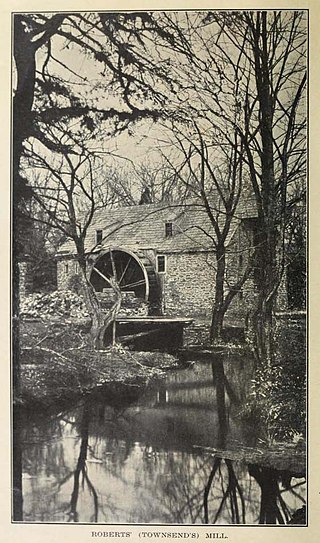
Wingohocking Creek was once a major tributary of another Philadelphia, Pennsylvania stream, Frankford Creek, which flows into the Delaware River. Frankford Creek was formed by the confluence of Wingohocking Creek and Tacony Creek. Since Wingohocking Creek is now obliterated, having been piped underground in the late 19th century, it can be confusing to look at a modern map, which shows Tacony Creek suddenly changing names "in the middle of the stream," so to speak, and becoming Frankford Creek. The point at which the name changes is near the present intersection of I and Ramona Streets, where the Wingohocking once joined the Tacony to form the Frankford Creek. What was once a major stream and the site of many mills and factories has been completely wiped off the map—all but the city's sewer maps, that is. The outlet of the Wingohocking Sewer is the largest in the Philadelphia sewer system, about 24 feet (7.3 m) high. It is visible from various points in the Juniata neighborhood and the adjoining golf course.

Cohocksink Creek

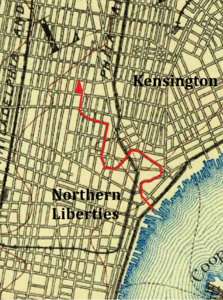
The Cohocksink Creek was formerly a stream running between what are now the Philadelphia neighborhoods of Northern Liberties and Kensington. It was a tributary of the Delaware River. Its name, spelled various ways, is said to come from a Lenape word for "pine lands". Alternate names included Stacey's Creek. The creek arose at the confluence of two smaller streams in a pond around the present-day intersection of Sixth and Thompson streets. For centuries, Cohocksink Creek has often been confused with Cohoquinoque Creek, a culverted stream about a mile to the south.

Chester Creek

Chester Creek is a 9.4-mile-long (15.1 km) tributary of the Delaware River in Delaware County, Pennsylvania in the United States.

Ridley Creek

Ridley Creek is a tributary of the Delaware River in Chester and Delaware counties, Pennsylvania in the United States.

Interstate 95 (I-95) is an Interstate highway running from Miami, Florida, north to Houlton, Maine. In the U.S. state of Pennsylvania, it runs 44.25 miles (71.21 km) from the Delaware state line near Marcus Hook in Delaware County northeast to the Delaware River–Turnpike Toll Bridge at the New Jersey state line near Bristol in Bucks County. From the Delaware state line to exit 40, the route is known by many as the Delaware Expressway, but is officially named the Vietnam Veterans Memorial Highway. North of exit 40, I-95 runs along the easternmost portion of the Pennsylvania Turnpike; this portion of road is not signed as part of the turnpike. I-95 parallels its namesake Delaware River for its entire route through the city of Philadelphia and its suburbs. It is a major route through the city and the metropolitan Delaware Valley, providing access to locally important landmarks such as Subaru Park, Philadelphia International Airport, the South Philadelphia Sports Complex, Penn's Landing, and Philadelphia Mills.

The Leiper Railroad was a 'family business built' horse drawn railroad of three quarters of a mile constructed in 1810 after the quarry owner, Thomas Leiper, failed to obtain a charter with legal rights-of-way to instead build his desired canal along Crum Creek. The quarry man's 'make-do' railroad was the continent's first chartered railway, first operational non-temporary railway, first well-documented railroad, and first constructed railroad also meant to be permanent.

The credit of constructing the first permanent tramway in America may therefore be rightly given to Thomas Leiper. He was the owner of a fine quarry not far from Philadelphia, and was much concerned to find an easy mode of carrying stone to tide-water. That a railway would accomplish this end he seem to have had no doubt. To test the matter, and at the same time afford a public exhibition of the merits of tramways, he built a temporary track in the yard of the Bull's Head Tavern in Philadelphia. The tramway was some sixty feet long, had a grade of one inch and a half to the yard, and up it, to the amazement of the spectators, one horse used to draw a four-wheeled wagon loaded with a weight of ten thousand pounds. This was the summer of 1809. Before autumn laborers were at work building a railway from the quarry to the nearest landing, a distance of three quarters of a mile. In the spring of 1810 the road began to be used and continued in using during eighteen years.
by John Bach McMaster, page 494, A History of the People of the United States, from the Revolution to the Civil War

Penn Treaty Park

Penn Treaty Park is a small park on the western bank of the Delaware River, in the Fishtown neighborhood of Philadelphia, Pennsylvania. It is located on Beach Street, near its intersection with Delaware Avenue.

Mill Creek (Philadelphia)

Mill Creek rises in Montgomery County, Pennsylvania; runs southeasterly to West Philadelphia, where it enters 19th-century sewer pipes; and debouches roughly five miles later in the Schuylkill River near The Woodlands Cemetery. It starts near Narbeth, where its source is buried, then runs free for a mile or so before entering Philadelphia at the Overbrook station.

Leiper Canal

Early in the 19th century, the Leiper Canal built in 1828-29 during the middle of the American canal age ran about 3 miles (5 km) along Crum Creek in Delaware County to its mouth in Eastern Pennsylvania's Delaware Valley carrying its owner‘s quarried products to docks on the Delaware River tidewater until 1852.

Fort Beversreede

Fort Beversreede was a Dutch-built palisaded factorij located near the confluence of the Schuylkill River and the Delaware River. It was an outpost of the colony of New Netherland, which was centered on its capital, New Amsterdam (Manhattan), on the North River.

Cohoquinoque Creek River

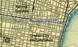
The Cohoquinoque Creek was formerly a stream running west to east through the Callowhill neighborhood in Philadelphia, along the southern part of Northern Liberties and immediately north of original northern boundary of Philadelphia. This small tributary of the Delaware River remains today, as a sewer, under Willow Street, which winds its way through what is sometimes called the East Callowhill Industrial District. Its name, spelled various ways, is said to be derived from a Lenni-Lenape word for "the grove of long pine trees." This was also the name of a nearby Lenape village.

Dock Street Market Shopping mall in Philadelphia

The Dock Street Market was Philadelphia's central wholesale produce market from 1870 until its closure in 1959 and relocation to the Food Distribution Center in South Philadelphia. The Dock Street Market was located on Dock Street in Society Hill. Dock Street is three blocks long, and runs from Sansom Street to Spruce Street, and between Third and Front streets. The market was busiest between midnight and eight in the morning when produce was loaded and offloaded between delivery trucks and warehouses.

References

Books

Articles

Newspaper

Websites

Coordinates: 39°56′43″N75°08′36″W / 39.9453°N 75.1434°W / 39.9453; -75.1434