Dog-hole ports

Last updated
Bixby Landing in Big Sur during 1911 was used to transport supplies and products to and from ships off shore. Bixby landing2.jpg
Bixby Landing in Big Sur during 1911 was used to transport supplies and products to and from ships off shore.

Dog-hole ports were the small, rural ports on the West Coast of the United States between Central California and Southern Oregon that operated between the mid-1800s until the 1930s. They were commonly called dog-holes because the schooners that served them would have to be able to "turn around in a harbor barely small enough for a dog". [1]

Contents

Available ports

There are only five major Pacific Ocean seaports in the United States between Canada and Mexico: Seattle; Portland, Oregon; San Francisco, Los Angeles, and San Diego. Of the other ports on the Redwood Coast only Caspar, Crescent City, Humboldt, Noyo and Mendocino could serve as ports for the largest coastwise and small deepwater vessels. Another 20 could hold medium-sized coasters. The rest, commonly known as dog-holes, could only serve the smallest of the ships. [2]

The Redwood Coast extended from San Simeon in California's Central coast to the Chetco River on Oregon's Southwestern coast. This coast is dominated by cliffs and bluffs uplifted from the ocean floor by waves and currents from marine terraces. Since there are few rivers to create ports, the topography made it difficult to handle cargo. Usually, lumber schooners were the only connecters between the lumber ports and the major cities. They brought all types of supplies to the ports and returned with boards, farm produce, and even livestock. Most of the hulls were built on the Pacific Coast and towed to San Francisco loaded with cargo for finishing. [3] [4]

Types of ports

Chutes and hoists were a West Coast innovation because of the high cliffs along the coast and the lack of harbors.

Mooring under a cliff to a buoy or by anchor, the ship received cargo down an apron chute or, later a wire hoist. It usually took two days to load. All these ports were full of rocks both hidden and exposed. There were undertows and cross-rip currents and continual changing sandbars. The dog-hole operators obtained franchises to build and manage the chutes. When a ship entered a port, it moored to a buoy (often a log anchored to the bottom) and would be warped or winched into position for loading. A ship’s boat, crewed by three seamen and the second mate, carried the eight inch mooring lines to the buoy.

Gravity chute

The gravity chutes were troughs allowing cargo to be sent down a cliff to a ship. Besides bagged goods, the chutes were used to load other cargo, such as live hogs. [5]

Cable hoist

High-strength steel cable or wire became available in the 1870s. [6] The cable hoist was a big improvement over the gravity chutes. They could load an entire sling of lumber at one time while the apron chutes could only load board by board. The cable hoist could be used to discharge, and load, cargo.

Where prevailing weather conditions permitted, shippers built wharves allowing the ships to come alongside and load directly from the dock. The wire hoist permitted ships with deeper drafts to load since they did not need to approach so close to shore. The wire hoists continued in use until after World War I and were discontinued in the north by the start of World War II and along the central coast after the opening of the Coast highway. [7]

Northern California

Along the rugged Sonoma coast during the 1800s, timber harvesters used small indentations in the coastal cliffs and headlands to load redwood lumber and other timber products onto small schooners and steamers. In 2016, the California State Parks and the National Oceanic and Atmospheric Administration Office of National Marine Sanctuaries surveyed sites. [8]

Central California

Along the Big Sur coast between Monterey and San Simeon, California, a number of landings were built to allow residents to receive supplies that could not be brought overland and businesses to load goods for transshipment to major ports on the coast. These landings were built in the last three decades of the 1800s. They employed either a hoist and cable or apron-style chute system. The hoist and cable system typically extended from a platform on a cliff ledge or marine terrace. The cable style chute was used at eight of the fourteen landings along the coast. Two apron-style chutes were located at Bixby Landing and Coal Chute Point.

As late as 1910, the winding, narrow coast road was still very rough and ended at the Pfeiffer Resort on the Big Sur River. It could be impassible in winter. Most goods including cheese produced on the Cooper Ranch were still shipped by boat to Monterey. [9]

Known ports include: [10]

Loading the ships

There were four major methods of loading ships at dog-holes: lightering, slide, apron or gravity chutes, wire or trapeze chutes, and wharfing. [11]

The Pacific Rural Press wrote in 1884, "San Francisco and San Diego are the only two good harbors on this long line of coast." It described chutes from 60 to 600 feet long consisting of wood forming a shallow trough that extended from a headland or high wharf or pier to water deep enough to allow vessels to load goods. [12]

At first shippers used lighters to ferry cargo out to anchored ships, but this was a slow process. By 1860 a gravity chute called an apron or slide chute was developed. It consisted of an A-frame on the bluff and an apron that could be adjusted to the height of the ships’ decks. Lumbermen sent down cargo from the bluff, which was as high as 150 feet (46 m), by the chute powered by gravity. A hinged gate covered with iron rode in the chute governed the speed of the wood. A primitive brake called a clapper provided additional control over the speed. It was a moveable plank tongue positioned on the outer end of the apron. It was the responsibility of the clapperman to regulate the speed by a lever. It was dangerous work; if the seaman slipped or the brakeman was slow, the lumber could kill or injure the crew member. [13] [12]

Mill operators generally built their lumber loading facilities on the lee (usually the south) side of a point. This allowed the land to break the force of the waves and caused the direction of the swells to roll straight into the cove. Schooners moored with their bows pointed directly into the waves so that they pitched (the ship going up and down along its long axis) but did not roll (going up and down along its crosswise axis). This made loading easier. [14]

Along the Big Sur coast, powdered lime was packed into barrels that were then attached to cable strung from the coastal cliff. The cargo was hoisted in slings from the landing along a cable winched about 50 yards out into the Pacific Ocean, where it was loaded aboard coastal schooners. The schooners were moored to deadeyes embedded in rocks of the adjacent shore. [15]

Related Research Articles

<span class="mw-page-title-main">Limekiln State Park</span> State historic park in California, United States

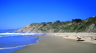
Limekiln State Park is a California state park on the Big Sur coast. It contains four lime kilns from an 1887–1890 lime-calcining operation, plus a beach, redwood forest, and 100-foot (30 m) Limekiln Falls. It is located 2 miles (3.2 km) south of Lucia on Big Sur Coast Highway. The 711-acre (288 ha) park was established in 1994.

<i>C.A. Thayer</i> (1895) Schooner

C.A. Thayer is a schooner built in 1895 near Eureka, California. The schooner has been preserved and open to the public at the San Francisco Maritime National Historical Park since 1963. She is one of the last survivors of the sailing schooners in the West coast lumber trade to San Francisco from Washington, Oregon, and Northern California. She was designated a National Historic Landmark on 13 November 1966.

<span class="mw-page-title-main">Elk, Mendocino County, California</span> Unincorporated community in California, United States

Elk is an unincorporated community in Mendocino County, California.

<span class="mw-page-title-main">Bixby Bridge</span> Highway bridge on the Big Sur Coast of California

Bixby Bridge, also known as Bixby Creek Bridge, on the Big Sur coast of California, is one of the most photographed bridges in California due to its aesthetic design, "graceful architecture and magnificent setting". It is a reinforced concrete open-spandrel arch bridge. The bridge is 120 miles (190 km) south of San Francisco and 13 miles (21 km) south of Carmel in Monterey County on State Route 1.

<span class="mw-page-title-main">Lost Coast</span> Region of California, United States

The Lost Coast is a mostly natural and undeveloped area of the California North Coast in Humboldt and Mendocino Counties, which includes the King Range. It was named the "Lost Coast" after the area experienced depopulation in the 1930s. In addition, the steepness and related geotechnical challenges of the coastal mountains made this stretch of coastline too costly for state highway or county road builders to establish routes through the area, leaving it the most undeveloped and remote portion of the California coast. Without any major highways, communities in the Lost Coast region such as Petrolia, Shelter Cove, and Whitethorn are somewhat isolated from the rest of California.

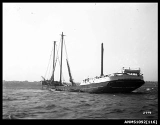
The West Coast lumber trade was a maritime trade route on the West Coast of the United States. It carried lumber from the coasts of Northern California, Oregon, and Washington mainly to the port of San Francisco. The trade included direct foreign shipment from ports of the Pacific Northwest and might include another product characteristic of the region, salmon, as in the schooner Henry Wilson sailing from Washington state for Australia with "around 500,000 feet of lumber and canned salmon" in 1918.

<span class="mw-page-title-main">Big River (California)</span> River in Mendocino County, California (USA), south of Mendocino Village

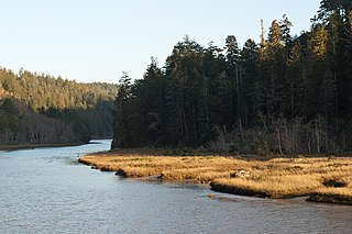
The Big River is a 41.7-mile-long (67.1 km) river in Mendocino County, California, that flows from the northern California Coast Range to the Pacific Ocean at Mendocino, Mendocino County, California. From the mouth, brackish waters extend 8 miles (13 km) upstream, forming the longest undeveloped estuary in the state.

<span class="mw-page-title-main">Salt Point State Park</span> State park in California, United States

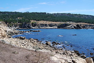
Salt Point State Park is a state park in Sonoma County, California, United States. The park covers 6,000 acres (2,428 ha) on the coast of Northern California, with 20 miles (32 km) of hiking trails and over 6 miles (9.7 km) of a rough rocky coastline including Salt Point which protrudes into the Pacific Ocean. The park also features the first underwater preserves in California. The constant impact of the waves forms the rocks into many different shapes. These rocks continue underwater providing a wide variety of habitats for marine organisms. The activities at Salt Point include hiking, camping, fishing, scuba diving and many others. The weather is often cool with fog and cold winds, even during the summer.

Rockport is a former settlement in an unincorporated area of Mendocino County, California. It is located 7.25 miles (12 km) north-northwest of Westport, at an elevation of 30 feet.

<span class="mw-page-title-main">Notleys Landing, California</span> Unincorporated community in California, United States

Notleys Landing is an uninhabited former hamlet in the Big Sur region of Monterey County, California. It was located near the mouth of the Palo Colorado Canyon 11 miles (18 km) south of the Carmel River, at an elevation of 112 feet.

<i>Inca</i> (schooner) Five-masted schooner Washington state, U.S.

The Inca was "the first true five-masted schooner built on the West Coast."

<span class="mw-page-title-main">Usal Creek</span> River in California, United States

Usal Creek is the southernmost drainage basin unbridged by California State Route 1 on California's Lost Coast. The unpaved county road following the westernmost ridge line south from the King Range crosses Usal Creek near the Pacific coast, but the bridge may be removed during winter months. Usal Creek, 9.7 miles (15.6 km) long, drains about 28 square miles (73 km2) on the Mendocino Coast and empties into the Pacific Ocean near the former company town of Usal.

The Caspar, South Fork & Eastern Railroad provided transportation for the Caspar Lumber Company in Mendocino County, California. The railroad operated the first steam locomotive on the coast of Mendocino County in 1875. Caspar Lumber Company lands became Jackson Demonstration State Forest in 1955, named for Caspar Lumber Company founder, Jacob Green Jackson.

<span class="mw-page-title-main">Fort Bragg and Southeastern Railroad</span> Former railway line in California, US

The Fort Bragg and Southeastern Railroad was formed by Atchison, Topeka and Santa Fe Railway as a consolidation of logging railways extending inland from Albion, California on the coast of Mendocino County. The railroad and its predecessors operated from August 1, 1885 to January 16, 1930. The line was merged into the regional Northwestern Pacific Railroad in 1907; but planned physical connection was never completed.

<span class="mw-page-title-main">Stewarts Point, California</span> Unincorporated community in California, United States

Stewarts Point is an unincorporated community in Sonoma County, California, United States and part of the "historic" Salt Point Township. Stewarts Point is located on the Pacific coast and California State Route 1, 20 miles (32 km) west of Healdsburg. Stewarts Point was originally part of the German Rancho, and was purchased by William Bihler in 1852. The unincorporated area is named for the first residents, the Stewart family, who moved to the area in 1856. In the official history for the United States Post Office, the name was said to have been given by Lt. Col. S. Stewart in 1888, however newspaper archives refer to the area as Stewarts Point as early as 1867, and attribute the name to the Stewart family who were the first residents in the area.

<span class="mw-page-title-main">Timber Cove, California</span> Census-designated place in California, United States

Timber Cove is a census-designated place (CDP) in Sonoma County, California. Timber Cove sits at an elevation of 554 feet (169 m). The 2010 United States census reported Timber Cove's population was 164.

<i>San Pedro</i> (steam schooner) American steam schooner

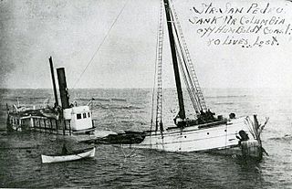
The steam schooner San Pedro (1899-1920) was the first vessel constructed by John Lindstrom's shipbuilding yard at Aberdeen, Washington in 1899. She was one of many steam schooners constructed by the yard that year, and weighed 456 tons. On October 3, 1905, the San Pedro accompanied the tugboat Pomo when the latter was towing the lumber schooner Santa Barbara, damaged by grounding, to Hunter's Point, California.

Bowen's Landing, California was a lumber port / "doghole port" about 86 miles (138 km) north of San Francisco.

The 1,534 acres (621 ha) Mill Creek Redwood Preserve is located in Big Sur, California, 6.8 miles (10.9 km) from Highway 1 on Palo Colorado Road. The park is owned by the Monterey Peninsula Regional Park District. To alleviate resistance by residents of Palo Colorado Canyon who were concerned about the impact of traffic on the narrow, one-lane road, access was limited to six visitors per day who must obtain a permit in advance from the district. The preserve was pieced together from several large properties between 1988 and 2000 at a cost of $2 million. When open, it is only accessible via trail from the road. The preserve was severely damaged by the Soberanes fire and is closed indefinitely.

References

  1. "Fort Ross State Historic Park (Fort Ross Conservancy)". Archived from the original on 2011-08-03. Retrieved 2011-08-16.
  2. Gary B. Griggs, Kiki Patsch, Lauret E. Savoy (2005) Living with the Changing California Coast (University of California Press, "The Northern California Coast" chapter 9, page 163) ISBN   9780520244474
  3. "Shipping". Mendocino Coast Model Railroad & Historic Society. Archived from the original on December 18, 2015. Retrieved December 20, 2015.
  4. Stephen Schwartz "Impact of the West Coast Lumber Trade" page 6 in Brotherhood of the Sea: A History of the Sailors’ Union of the Pacific, 1885-1985 (Transaction Publishers. 1986) ISBN   9780887381218
  5. "Chutes". Mendocino Coast Model Railroad & Historic Society. Archived from the original on December 20, 2015. Retrieved December 20, 2015.
  6. Donald Sayenga. "Modern History of Wire Rope". Atlantic Cable.com. Archived from the original on February 3, 2014. Retrieved December 20, 2015.
  7. Williams, Richard L. (1976). The Loggers . Alexandria, Virginia: Time-Life Books. p.  72. ISBN   0-8094-1527-5.
  8. "Doghole Ports Project | Greater Farallones National Marine Sanctuary". farallones.noaa.gov. Archived from the original on 2 May 2023. Retrieved 2 May 2023.
  9. Cheese Made Down the Coast Archived 2023-05-24 at the Wayback Machine Monterey Daily Express. Monterey, California. June 7, 1911. page 1.
  10. Field, Jason. Big Sur Doghole Ports: A Frontier Maritime Cultural Landscape Archived 2023-05-02 at the Wayback Machine . Sonoma State University. 2017
  11. A.W. Roberts. "Chute Design Considerations For Feeding And Transfer". Centre for Bulk Solids and Particulate Technologies. Archived from the original on December 5, 2015. Retrieved December 20, 2015.
  12. 1 2 "Shipping Lumber on the Coast". cdnc.ucr.edu. Pacific Rural Press. 20 September 1884. Archived from the original on 29 May 2023. Retrieved 29 May 2023.
  13. Lynwood Carranco, John T. Labbe, “Mendocino Landings” page 38 in Logging the Redwoods (Caxton Press, 1975) ISBN   9780870043734
  14. Harry Lindstrom (2013). "Lumber Landings, Doghole Schooners And Shipwrecks". mendocinohistory. Retrieved December 20, 2015.
  15. McGlynn, Betty Hoag (September 1, 1988). "Partington Landing: of Poets, Artists, and Ships in the Big Sur Country" (PDF). Noticias del Puerto de Monterey. The Monterey History and Art Association. 24 (3). Archived from the original (PDF) on March 23, 2019. Retrieved 23 March 2019.

Other sources