
Kokhav HaShahar is an Israeli settlement in the northern West Bank, organized as a community settlement in the Binyamin region. Located on a mountain ridge overlooking the Jordan Valley and accessible via the Allon Road, it falls under the municipal jurisdiction of Mateh Binyamin Regional Council. In 2022, it had a population of 2,501.
Ofra is an Israeli settlement located in the northern Israeli-occupied West Bank. Located on the main road between Jerusalem and Nablus, it falls under the jurisdiction of Mateh Binyamin Regional Council. In 2022 it had a population of 3,497.

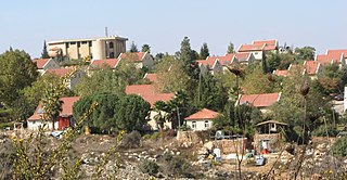
Talmon is an Israeli settlement in the West Bank located 8 km from Ramallah, next to the Palestinian villages of Al-Janiya, Al-Ittihad, and Al-Zaitounah – part of whose lands were confiscated for the construction of Talmon. The international community considers Israeli settlements in the West Bank illegal under international law, but the Israeli government disputes this.
Ma'ale Levona is an Israeli settlement organized as a community settlement in the West Bank. Located to the south-east of Ariel, it falls under the jurisdiction of Mateh Binyamin Regional Council. In 2022, it had a population of 1,018.

Ateret is an Israeli settlement organized as a community settlement in the West Bank. Located in the municipal jurisdiction of the Mateh Binyamin Regional Council, it is located on a hilltop, at an elevation of 760 metres, occupying land confiscated by Israel from three nearby Palestinian villages: Ajjul, 'Atara, and Umm Safa. In 2022 it had a population of 891.

Beit Horon is a communal Israeli settlement in the West Bank. Bordering Route 443 between Modi'in and Jerusalem, the biblical pass of Beit Horon, after which it is named, it falls under the jurisdiction of Mateh Binyamin Regional Council. In 2022 it had a population of 1,442.

Giv'on HaHadashah is an Israel settlement in the West Bank, built over land expropriated from the neighboring Palestinian villages of Biddu, Beit Ijza, and Al Jib. It falls under the jurisdiction of Mateh Binyamin Regional Council. In 2022 it had a population of 996.

Shvut Rachel is a former Israeli settlement in the West Bank, retroactively designated a neighborhood of the settlement of Shilo, in the West Bank. Shvut Rachel sits between the Palestinian villages of Turmus Ayya, Qaryut and Jalud, part of whose lands were expropriated for building Shvut Rachel. Nearby Israeli settlements include Shilo, Giv'at Har'el, Esh Kodesh, Keeda, and Adei Ad. The village, administrated by the Matte Binyamin Regional Council, has a population of 100 families. The international community considers Israeli settlements in the West Bank illegal under international law, but the Israeli government disputes this. The Sasson Report in 2005 noted that the settlement extends over Palestinian land, part of which is owned by Fawzi Haj Ibrahim Mohammad from Jalud, turned over to the settlement after the Israeli authorities declared it state land.

Hashmonaim is an Israeli settlement located in the western section of the West Bank, off Route 443. Hashmonaim is located two kilometers east of Modi'in-Maccabim-Re'ut, midway between Jerusalem and Tel Aviv and is part of the Mateh Binyamin Regional Council. In 2022 it had a population of 2,589.

Deir Ibzi is a Palestinian town in the Ramallah and al-Bireh Governorate, located west of Ramallah in the northern West Bank. According to the Palestinian Central Bureau of Statistics, the town had a population of 2,590 inhabitants in 2017.

Al-Janiya is a Palestinian village in the Ramallah and al-Bireh Governorate located 8 kilometers northwest of Ramallah in the northern West Bank. According to the Palestinian Central Bureau of Statistics (PCBS), the village had a population of 1,296 inhabitants by 2017.

Ein Qiniya or 'Ayn Kiniya is a Palestinian village in the northern West Bank, located 7 kilometers (4.3 mi) northwest of Ramallah and part of the Ramallah and al-Bireh Governorate of the State of Palestine. Ein Qiniya has existed since the Roman-era of rule in Palestine. The village is very small with no public structures or institutions and is governed by a local development committee. Ein Qiniya is regionally notable for being a spring and autumn time picnic resort.

Halamish, also known as Neveh Tzuf, is an Israeli settlement in the West Bank, located in the southwestern Samarian hills to the north of Ramallah, 10.7 kilometers east of the Green line. The Orthodox Jewish community was established in 1977. It is organised as a community settlement and falls under the jurisdiction of Mateh Binyamin Regional Council. In 2022 it had a population of 1,590. On a hill within the settlement is Hovlata, an archeological site dating to the Hasmonean period.

Kfar HaOranim, also known as Menora or Giv'at Ehud, is an Israeli settlement in the West Bank. Contiguous with Lapid and located near to the major city of Modi'in, it is organised as a community settlement and falls under the jurisdiction of Mateh Binyamin Regional Council. In 2022 it had a population of 2,604.

Kokhav Ya'akov is a religious Israeli settlement organized as a community settlement in the West Bank. Located near the Palestinian town of al-Bireh, it is administered by Mateh Binyamin Regional Council. In 2022 it had a population of 9,794. The settlement is north of Jerusalem and close to the Palestinian city of Ramallah.

Na'ale is an Israeli settlement in the West Bank. Located near Modi'in, it falls under the jurisdiction of Mateh Binyamin Regional Council. In 2022 it had a population of 2,839.

Nahliel is a Haredi Israeli settlement in the West Bank. Located close to the Palestinian villages of Beitillu and Deir 'Ammar, and some 20 kilometres (12 mi) from Modi'in, it is organised as a community settlement and falls under the jurisdiction of the Mateh Binyamin Regional Council. In 2022 it had a population of 743.

Al-Zaitounah is a Palestinian town in the Ramallah and al-Bireh Governorate of the State of Palestine. It was formed in 2005 as the result of a merger of the villages of Abu Shukheidim and al-Mazra'a al-Qibliya. In 2007, al-Zaitounah had a population of 6,190, according to the Palestinian Central Bureau of Statistics.

Sha'ar Binyamin is an Israeli light industrial park in the occupied West Bank, built in 1998 over land expropriated from the Palestinian villages of Jaba' and Mukhmas. It is located the Mateh Binyamin Regional Council, Israeli-occupied West Bank, located 2km north of Geva Binyamin on Route 60 and about 5 minutes drive from Pisgat Ze'ev in Jerusalem. The park covers an area of 606 dunams.
On 23 August 2019, 17-year-old Israeli Rina Shnerb was killed by a roadside bomb while hiking with her father, Rabbi Eitan Shnerb, and brother Dvir near Dolev, an Israeli settlement in the West Bank; her father and brother were wounded. Shnerb's funeral was held in Lod on 23 August.


