Eli is a large Israeli settlement in the West Bank organized as a community settlement, located on Highway 60, north of Ramallah, between the Palestinian villages of As-Sawiya and Qaryut, part of whose lands were expropriated for the establishment of Eli. The international community considers Israeli settlements in the West Bank illegal under international law, but the Israeli government disputes this.

Rehelim is an Israeli settlement in the northern West Bank. Located on Route 60, between Kfar Tapuach and Eli, east of Ariel and adjacent to the Palestinian towns of Yatma and Qabalan, it falls under the jurisdiction of Shomron Regional Council. In 2022, it had a population of 1,062. In January 2021, under Benjamin Netanyahu, the Israeli government decided to legalize the illegal, nearby outpost of Nofei Nehemia, by reclassifying it as a “neighborhood” of the Rehelim settlement, which itself was an illegal outpost that was legalized a few years prior.

Itamar is an Israeli settlement located in the West Bank's Samarian mountains, five kilometers southeast of the Palestinian city of Nablus. The settlement was built on land confiscated from the Palestinian villages of Awarta, Beit Furik,Yanun, Aqraba and Rujeib. The predominantly Orthodox and Religious Zionist Jewish community falls in part within the municipal jurisdiction of the Shomron Regional Council. Under the terms of the Oslo Accords of 1993 between Israel and the Palestine Liberation Organization, Itamar was designated Area "C", under provisional Israeli civil and security control, before a transition period after which Area "C" was to be handed back to the Palestinians. In 2022, it had a population of 1,470.

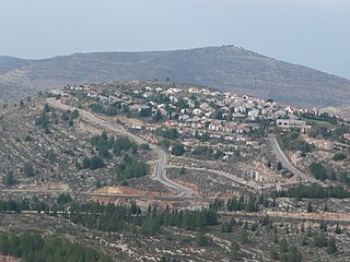
Yitzhar is an Israeli settlement located in the West Bank, south of the city of Nablus, just off Route 60, north of the Tapuach Junction. The predominantly Orthodox Jewish community falls under the jurisdiction of Shomron Regional Council. In 2022, it had a population of 2,093.
Keida, also transcribed Kida, is an Israeli outpost in the West Bank named after a genus of flower that grows in the region. It is situated just off the Allon Road, a five-minute drive east of Shilo, which is the mother-town of these outposts. It forms one of six Israeli outposts, built on land seized from the Palestinian villages of Jalud, Qaryut, Turmus Ayya and al-Mughayir. Among the other settlements belonging to the group at Shvut Rachel, Giv'at Har'el, Esh Kodesh, Ahiya and Adei Ad. Keida was established without a master plan or permission to build. The international community considers Israeli settlements in the West Bank illegal under international law, but the Israeli government disputes this.

Shvut Rachel is a former Israeli settlement in the West Bank, retroactively designated a neighborhood of the settlement of Shilo, in the West Bank. Shvut Rachel sits between the Palestinian villages of Turmus Ayya, Qaryut and Jalud, part of whose lands were expropriated for building Shvut Rachel. Nearby Israeli settlements include Shilo, Giv'at Har'el, Esh Kodesh, Keeda, and Adei Ad. The village, administrated by the Matte Binyamin Regional Council, has a population of 100 families. The international community considers Israeli settlements in the West Bank illegal under international law, but the Israeli government disputes this. The Sasson Report in 2005 noted that the settlement extends over Palestinian land, part of which is owned by Fawzi Haj Ibrahim Mohammad from Jalud, turned over to the settlement after the Israeli authorities declared it state land.

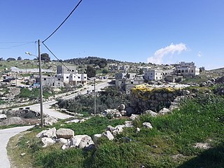
Duma is a Palestinian town in the Nablus Governorate in the northern West Bank, located 25 kilometers southeast of Nablus. According to the Palestinian Central Bureau of Statistics, the town had a population of 2,674 inhabitants in 2017. Duma's total land area consists of 17,351 dunams, about 200 of which are designated as built-up area.

Burin is a Palestinian village in the Nablus Governorate of the State of Palestine, in the northern West Bank, located 7 kilometres (4.3 mi) southwest of Nablus. The town had a population of 2,844 in 2017.
Qaryout is a Palestinian village in the Nablus Governorate in the northern West Bank, located 28 kilometers (17 mi) southeast of Nablus.
Qusra is a Palestinian village in the Nablus Governorate of the State of Palestine, in the northern West Bank, located 28 kilometers southeast of Nablus. According to the Palestinian Central Bureau of Statistics (PCBS), Qusra had a population of 5,418 inhabitants in 2017.

Urif is a Palestinian village in the Nablus Governorate of the State of Palestine, in the northern West Bank, located 13 kilometers south of Nablus. According to the Palestinian Central Bureau of Statistics (PCBS), the town had a population of 3,624 inhabitants in 2017.

al-Mughayyir is a Palestinian village in the Ramallah and al-Bireh Governorate, located 27 kilometers Northeast of Ramallah and 34 kilometers Southeast of Nablus, in the northern West Bank. According to the Palestinian Central Bureau of Statistics (PCBS), the village had a population of 2,872 inhabitants in 2017.

Halamish, also known as Neveh Tzuf, is an Israeli settlement in the West Bank, located in the southwestern Samarian hills to the north of Ramallah, 10.7 kilometers east of the Green line. The Orthodox Jewish community was established in 1977. It is organised as a community settlement and falls under the jurisdiction of Mateh Binyamin Regional Council. In 2022 it had a population of 1,590. On a hill within the settlement is Hovlata, an archeological site dating to the Hasmonean period.

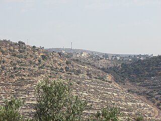
Esh Kodesh is an Israeli outpost in the West Bank near Shilo. It falls under the jurisdiction of the Mateh Binyamin Regional Council. Israeli outposts in the West Bank are considered illegal both under international law as well as under Israeli law. The population in 2005 was under 12 families.
Tawani or at-Tuwani is a small Palestinian village in the south Hebron Hills of the Hebron Governorate. Many of the village's residents live in caves. The village is located south-east of the village of Yatta. Approximately one kilometre away lies Tel Tuwani, near the Israeli settlement of Ma’on. Frequent disputes occur between at-Tawani's residents and settlers over land, roads and water resources. The village had a population of 194 residents in 2017.

Jalud is a Palestinian village in the Nablus Governorate in the northern West Bank. It is approximately 30 kilometers (19 mi) south of Nablus and is situated just east of Qaryut, south of Qusra and northeast of Shilo, an Israeli settlement. Its land area consists of 16,517 dunams, 98 of which constitutes its built-up area. Jalud is encircled by four illegal outposts: Esh Kodesh, Adi Ad, Ahiya and Shvut Rachel. Jalud residents were blocked by both IDF forces and settlers from tending most of their farms from 2001 to 2007. In 2007 permission was given to farm their groves, twice a year for a few days, on condition that prior coordinating arrangements are made with the IDF.
Al Bowereh or Al-Bweireh, also known as Aqabat Injeleh, is a Palestinian village located just east of Hebron. It is situated adjacent to and north of the Israeli settlement of Givat Harsina. The village is occupied by Israel since 1967, together with the rest of the West Bank.

On 31 July 2015, Israeli settlers firebombed a Palestinian family home in late July 2015 in the village of Duma, killing three people; 18-month-old Ali Dawabsheh was burned alive in the fire, while both his parents died from their injuries within weeks. On 3 January 2016, 21 year old Israeli settler Amiram Ben-Uliel was indicted for the murder, along with an Israeli minor, for participation in planning the murder. In addition, along with two others, they were both charged with one count of membership in a terrorist organization.
Meir Ettinger is an Israeli Kahanist activist and extremist known for leading the Hilltop Youth, a group that pursues the expansion of Israeli settlements in the West Bank, conducts punitive price tag attacks on Palestinian villages, and targets Muslim and Christian sites. Ettinger has called for the demolition of the secular state of Israel, and its replacement by a religious society based on Biblical principles.