Geva Binyamin

Last updated

Contents

Geva Binyamin
Geva Binyamin.JPG
Israel outline binyamin.png
Red pog.svg
Geva Binyamin
Coordinates: 31°51′0″N35°16′26″E / 31.85000°N 35.27389°E / 31.85000; 35.27389
District Judea and Samaria Area
Council Mateh Binyamin
Region West Bank
Founded1984
Founded byAdam gar'in members
Population
 (2022)
5,913 [1]
Website www.geva-binyamin.org.il

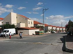
Geva Binyamin (Hebrew : גֶּבַע בִּנְיָמִין, lit. 'Benjamin Hill'), also known as Adam (Hebrew : אדם), is an Israeli settlement in the West Bank, built over land expropriated from the Palestinian village of Jaba'. It is organised as a community settlement and falls under the jurisdiction of Mateh Binyamin Regional Council. In 2022, it had a population of 5,913.

The international community considers Israeli settlements in the West Bank illegal under international law, but the Israeli government disputes this. [2]

Etymology

The name Geva Binyamin comes from an eponymous Biblical site – Geba of Benjamin – which is believed to have stood around the same location. [3] According to contemporary scholarship, Geba of Benjamin was located in the nearby village of Jaba', which preserves the biblical name. [4]

History

According to ARIJ, Israel confiscated 1,139 dunams of land from the Palestinian village of Jaba' in order to construct Geva Binyamin. [5] Some Jaba' residents have reportedly managed to return to part of their land fenced off by the settlers of Geva Binyamin. [6]

The village was established in 1984 by members of the Adam gar'in (named after Yekutiel Adam, a former Deputy Chief of Staff of the Israeli Defence Forces who had been killed two years earlier in Lebanon). [7]

Qubur Bani Isra'il is located on the outskirts of the settlement.

When Migron, the largest Israeli outpost in the West Bank, was found to be illegal and furthermore, established largely on private Palestinian land, the mandatory evacuation plan foresaw, as a compromise with the affected settlers, a major expansion of Geva Binyamin in order ostensibly to house the Mignon evacuees. However, the announced expansion of Geva Binyamin spoke of the construction of 1,400 housing units, notwithstanding the fact that the Mignon settlement to be abolished had only 50 family units. [8]

Plans have been advanced to expand Jewish settlement northwards from Neve Ya'akov towards Geva Binyamin in order to create a seamless continuity between Jewish communities in this area of the West Bank, and it is thought the main purpose is block the urban expansion of Al-Ram and Hizma, something which would leave the settlement isolated. [9]

Related Research Articles

<span class="mw-page-title-main">Efrat (Israeli settlement)</span> Israeli settlement in the West Bank

Efrat, or previously officially Efrata, is an Israeli settlement in the West Bank, established in 1983 in the Judean Mountains. Efrat is located 12 kilometers (7.5 mi) south of Jerusalem, between Bethlehem and Hebron, 6.5 km (4 mi) east of the Green Line, at the Palestinian side of the West Bank wall. The settlement stands at an altitude of up to 960 metres above sea level and covers about 6,000 dunam. The international community has largely viewed Israeli settlements in the West Bank, referred to by Israel as Judea and Samaria, as illegal under international law. However, Israel disputes this interpretation and maintains that settlements are legal and consistent with international law, citing historical, legal, and security reasons. This position has been upheld by successive Israeli governments.

<span class="mw-page-title-main">Kokhav HaShahar</span> Israeli settlement in the West Bank

Kokhav HaShahar is an Israeli settlement in the northern West Bank, organized as a community settlement in the Binyamin region. Located on a mountain ridge overlooking the Jordan Valley and accessible via the Allon Road, it falls under the municipal jurisdiction of Mateh Binyamin Regional Council. In 2022, it had a population of 2,501.

<span class="mw-page-title-main">Talmon</span> Israeli settlement in the West Bank

Talmon is an Israeli settlement in the West Bank located 8 km from Ramallah, next to the Palestinian villages of Al-Janiya, Al-Ittihad, and Al-Zaitounah – part of whose lands were confiscated for the construction of Talmon. The international community considers Israeli settlements in the West Bank illegal under international law, but the Israeli government disputes this.

<span class="mw-page-title-main">Ma'ale Mikhmas</span> Israeli settlement in the West Bank

Ma'ale Mikhmas is an Israeli settlement in the Binyamin region of the northern West Bank. Located a few miles northeast of Jerusalem, it falls under the municipal jurisdiction of Mateh Binyamin Regional Council and according to Palestinians the Ramallah and al-Bireh Governorate. In 2022 it had a population of 1,744.

<span class="mw-page-title-main">Ma'ale Efrayim</span> Israeli settlement in the West Bank

Ma'ale Efrayim is an Israeli settlement in the West Bank, organized as a secular settlement and a local council, located along the eastern slopes of the Samarian mountains in the Jordan Valley. It was founded in 1978 and named after the Biblical tribe of Ephraim. The settlement's municipal status was upgraded to local council in 1981. In 2022, it had a population of 1,377.

<span class="mw-page-title-main">Ma'ale Levona</span> Israeli settlement in the West Bank

Ma'ale Levona is an Israeli settlement organized as a community settlement in the West Bank. Located to the south-east of Ariel, it falls under the jurisdiction of Mateh Binyamin Regional Council. In 2022, it had a population of 1,018.

<span class="mw-page-title-main">Rosh Tzurim</span> Israeli settlement in the West Bank

Rosh Tzurim is an Israeli settlement and religious kibbutz in the West Bank established in 1969. It is located about 20 kilometers (12 mi) south of Jerusalem, 3.9 km east of the Green Line, inside barrier wall. A member of the Religious Kibbutz Movement, it falls under the jurisdiction of the Gush Etzion Regional Council. In 2022 it had a population of 978.

<span class="mw-page-title-main">Beit Horon</span> Israeli settlement in the West Bank

Beit Horon is a communal Israeli settlement in the West Bank. Bordering Route 443 between Modi'in and Jerusalem, the biblical pass of Beit Horon, after which it is named, it falls under the jurisdiction of Mateh Binyamin Regional Council. In 2022 it had a population of 1,442.

<span class="mw-page-title-main">Giv'on HaHadasha</span> Israeli settlement in the West Bank

Giv'on HaHadashah is an Israel settlement in the West Bank, built over land expropriated from the neighboring Palestinian villages of Biddu, Beit Ijza, and Al Jib. It falls under the jurisdiction of Mateh Binyamin Regional Council. In 2022 it had a population of 996.

Hizma is a Palestinian town in the Jerusalem Governorate, seven kilometers from Jerusalem's Old City. The town, mostly located in Area C of the West Bank, borders four Israeli settlements, Neve Yaakov and Pisgat Ze'ev, Geva Binyamin and Almon.

<span class="mw-page-title-main">Jaba', Jerusalem</span> Municipality type D in Jerusalem, State of Palestine

Jaba’ is a Palestinian town in the Jerusalem Governorate of the State of Palestine, located northeast of Jerusalem in the central West Bank. According to the Palestinian Central Bureau of Statistics, the town had a population of 3,921 in 2017.

<span class="mw-page-title-main">Geva Carmel</span> Place in Haifa, Israel

Geva Carmel is a moshav in northern Israel. Located near Atlit, it falls under the jurisdiction of Hof HaCarmel Regional Council. In 2022 it had a population of 1,205.

<span class="mw-page-title-main">Gilgal (Israeli settlement)</span> Israeli settlement in the West Bank

Gilgal is an Israeli settlement organized as a kibbutz in the West Bank. Located in the Jordan Valley around 16 kilometres north of Jericho with an area of 1,400 dunams, it falls under the jurisdiction of Bik'at HaYarden Regional Council. In 2022 it had a population of 229.

<span class="mw-page-title-main">Na'omi</span> Israeli settlement in the West Bank

Na'omi is an Israeli settlement organized as a moshav shitufi in the West Bank. Located in the Jordan Valley three kilometres north of Hisham's Palace, it falls under the jurisdiction of Bik'at HaYarden Regional Council. In 2022 it had a population of 247.

Almon, also known as Anatot, is an Israeli settlement in the West Bank, organized as a community settlement. Built over land confiscated from the nearby Palestinian town of 'Anata, it falls under the jurisdiction of the Mateh Binyamin Regional Council. In 2022 it had a population of 1,467.

<span class="mw-page-title-main">Dolev</span> Israeli settlement in the West Bank

Dolev is an Israeli settlement organized as a community settlement in the West Bank. Located 17 mi (27 km) north-west of Jerusalem, it falls under the jurisdiction of Mateh Binyamin Regional Council. In 2022 it had a population of 1,613.

<span class="mw-page-title-main">Halamish</span> Israeli settlement in the West Bank

Halamish, also known as Neveh Tzuf, is an Israeli settlement in the West Bank, located in the southwestern Samarian hills to the north of Ramallah, 10.7 kilometers east of the Green line. The Orthodox Jewish community was established in 1977. It is organised as a community settlement and falls under the jurisdiction of Mateh Binyamin Regional Council. In 2022 it had a population of 1,590. On a hill within the settlement is Hovlata, an archeological site dating to the Hasmonean period.

<span class="mw-page-title-main">Kfar Adumim</span> Israeli settlement in the West Bank

Kfar Adumim is a mixed religious-secular Israeli settlement in the West Bank. It is located in the Judean Desert, on the southern bank of Wadi Qelt, about 2 miles northeast of the town Ma'ale Adumim. It is at 367 meters above sea level. It is organized as a community settlement and falls under the jurisdiction of Mateh Binyamin Regional Council. In 2022 it had a population of 4,957. The Israel Central Bureau of Statistics counts the populations of nearby settlements Alon and Nofei Prat as part of the population of Kfar Adumim.

<span class="mw-page-title-main">Nofei Prat</span> Israeli settlement in the West Bank

Nofei Prat is an Israeli settlement organized as a community settlement in the West Bank. Located near Ma'ale Adumim, it falls under the jurisdiction of Mateh Binyamin Regional Council. In 2006 around 90 families were living in the settlement. In 2009 about 140 families lived there. Both religious and secular families live in Nofei Prat.

<span class="mw-page-title-main">Sha'ar Binyamin Industrial Zone</span> Israeli settlement in West Bank

Sha'ar Binyamin is an Israeli light industrial park in the occupied West Bank, built in 1998 over land expropriated from the Palestinian villages of Jaba' and Mukhmas. It is located the Mateh Binyamin Regional Council, Israeli-occupied West Bank, located 2km north of Geva Binyamin on Route 60 and about 5 minutes drive from Pisgat Ze'ev in Jerusalem. The park covers an area of 606 dunams.

References

  1. "Regional Statistics". Israel Central Bureau of Statistics. Retrieved 21 March 2024.
  2. "The Geneva Convention". BBC News. 10 December 2009. Retrieved 27 November 2010.
  3. Carta's Official Guide to Israel and Complete Gazetteer to all Sites in the Holy Land. (3rd edition 1993) Jerusalem, Carta, p.165, ISBN   965-220-186-3 (English)
  4. Finkelstein, Israel (2018). Hasmonean realities behind Ezra, Nehemiah, and Chronicles. SBL Press. pp. 41–42. ISBN   978-0-88414-307-9. OCLC   1081371337.
  5. Jaba' Village Profile, ARIJ, p. 17
  6. Michael Sfard,The Wall and the Gate: Israel, Palestine, and the Legal Battle for Human Rights, Henry Holt and Company 2018 ISBN   978-1-250-12271-1 p.361
  7. Adam Binyamin Region
  8. Galia Golan, Gilead Sher, Spoiling and Coping with Spoilers: Israeli-Arab Negotiations, Indiana University Press, 2019 ISBN   978-0-253-04239-2 p.72.
  9. Francesco Chiodelli , Shaping Jerusalem: Spatial planning, politics and the conflict, Taylor & Francis, 2016 ISBN   978-1-317-28909-8 p.104.