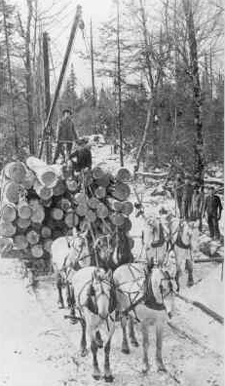
Donald, Wisconsin

Last updated
Donald, Wisconsin
USA Wisconsin location map.svg
Red pog.svg
Donald, Wisconsin
Usa edcp location map.svg
Red pog.svg
Donald, Wisconsin
Coordinates: 45°15′09″N90°53′49″W / 45.25250°N 90.89694°W / 45.25250; -90.89694 Coordinates: 45°15′09″N90°53′49″W / 45.25250°N 90.89694°W / 45.25250; -90.89694
Country Flag of the United States.svg  United States
State Flag of Wisconsin.svg  Wisconsin
County Taylor
Elevation
366 m (1,201 ft)
Time zone UTC-6 (Central (CST))
  Summer (DST) UTC-5 (CDT)
Area code(s) 715 & 534
GNIS feature ID1564049 [1]

Donald is an unincorporated community located in the town of Pershing, Taylor County, Wisconsin, United States, [1] where the Canadian National Railway crosses County Highway M.

Fountain-Campbell Lumber Company in operation, 1909 Logging sleigh.jpg
Fountain-Campbell Lumber Company in operation, 1909

History

Donald was founded in 1903. [2] It was named by for Donald Campbell, the son of the president of the Fountain-Campbell Lumber Company, which logged in the area. Before that, the spot was called Fountain Spur, for the other principal of that company. [2] A post office was established at Donald in 1904, and remained in operation until it was discontinued in 1942. [3]

Notes

  1. 1 2 "Donald, Wisconsin". Geographic Names Information System . United States Geological Survey.
  2. 1 2 Chicago and North Western Railway Company (1908). A History of the Origin of the Place Names Connected with the Chicago & North Western and Chicago, St. Paul, Minneapolis & Omaha Railways. p. 173.
  3. "Taylor County". Jim Forte Postal History. Retrieved 3 April 2015.


Related Research Articles

Chicago and North Western Transportation Company Rail transport company

The Chicago and North Western was a Class I railroad in the Midwestern United States. It was also known as the "North Western". The railroad operated more than 5,000 miles (8,000 km) of track at the turn of the 20th century, and over 12,000 miles (19,000 km) of track in seven states before retrenchment in the late 1970s. Until 1972, when the employees purchased the company, it was named the Chicago and North Western Railway.

Chicago, St. Paul, Minneapolis and Omaha Railway

The Chicago, St. Paul, Minneapolis and Omaha Railway or Omaha Road was a railroad in the U.S. states of Nebraska, Iowa, Minnesota, Wisconsin and South Dakota. It was incorporated in 1880 as a consolidation of the Chicago, St. Paul and Minneapolis Railway and the North Wisconsin Railway. The Chicago and North Western Railway (C&NW) gained control in 1882. The C&NW leased the Omaha Road in 1957 and merged the company into itself in 1972. Portions of the C. St. P. M. and O. are part of the Union Pacific Railroad network. This includes main lines from Wyeville, Wisconsin, to St. Paul, Minnesota, and St. Paul to Sioux City, Iowa.

Hunting, Wisconsin is a former unincorporated community of Shawano and Waupaca Counties, located in the towns of Belle Plaine and Matteson, along the north shore of the Embarrass River, United States. Today little more remains of the community than the name of the road that traverses it: "Hunting Road."

Stitzer is an unincorporated community in the town of Liberty in Grant County, Wisconsin, United States.

Larsen is an unincorporated community in the town of Clayton, in Winnebago County, Wisconsin, United States.

Shepley is an unincorporated community at the border of the towns of Birnamwood and Almon, Wisconsin in Shawano County, Wisconsin, United States.

Bluff Siding, Wisconsin Unincorporated community in Wisconsin, United States

Bluff Siding or Atlanta Station is an unincorporated community located in the town of Buffalo, in Buffalo County, Wisconsin, United States.

Marshland, Wisconsin Unincorporated community in Wisconsin, United States

Marshland is an unincorporated community located in the town of Buffalo, in Buffalo County, Wisconsin, United States. Marshland is located on Wisconsin Highway 35 and Wisconsin Highway 54 8.5 miles (13.7 km) east-southeast of Fountain City.

Angus is an unincorporated community in the town of Cedar Lake, Barron County, Wisconsin, United States. Angus is located on Wisconsin Highway 48 2.5 miles (4.0 km) southwest of Birchwood.

Elmo is an unincorporated community located in the town of Smelser, Grant County, Wisconsin, United States.

Saint Rose is an unincorporated community located in the town of Smelser, Grant County, Wisconsin, United States.

Klevenville is an unincorporated community located in the town of Springdale, Dane County, Wisconsin, United States.

Riley is an unincorporated community located in the town of Springdale, Dane County, Wisconsin, United States.

Stiles Junction is an unincorporated community located in the town of Stiles, Oconto County, Wisconsin, United States.

Koshkonong is an unincorporated community located in the towns of Koshkonong, Jefferson County and Milton, Rock County, Wisconsin, United States.

Ashland Junction is an unincorporated community located in the town of Eileen, Bayfield County, Wisconsin, United States.

Northline is an unincorporated community located in the town of Hudson, St. Croix County, Wisconsin, United States.

McMillan is an unincorporated community in the town of McMillan, Marathon County, Wisconsin, United States which was at one time an incorporated village.

Preston is an unincorporated community in the towns of Fennimore and Wingville, Grant County, Wisconsin, United States.

Werley is an unincorporated community in the town of Mount Ida, Grant County, Wisconsin, United States, at latitude 43.019 and longitude -90.765, where Star Lane feeds into County Road K, roughly five miles west-northwest of Fennimore.