Doucier

Last updated

Doucier
Doucier (Jura) - eglise.JPG
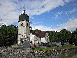
The church in Doucier
Blason ville fr Doucier 39.svg
Location of Doucier
Doucier
France location map-Regions and departements-2016.svg
Red pog.svg
Doucier
Bourgogne-Franche-Comte region location map.svg
Red pog.svg
Doucier
Coordinates: 46°39′20″N5°46′47″E / 46.6556°N 5.7797°E / 46.6556; 5.7797
Country France
Region Bourgogne-Franche-Comté
Department Jura
Arrondissement Lons-le-Saunier
Canton Saint-Laurent-en-Grandvaux
Government
  Mayor (20202026) Nathalie Roux [1]
Area
1
12.52 km2 (4.83 sq mi)
Population
 (2022) [2]
281
  Density22/km2 (58/sq mi)
Time zone UTC+01:00 (CET)
  Summer (DST) UTC+02:00 (CEST)
INSEE/Postal code
39201 /39130
Elevation447–635 m (1,467–2,083 ft)
1 French Land Register data, which excludes lakes, ponds, glaciers > 1 km2 (0.386 sq mi or 247 acres) and river estuaries.

Doucier (French pronunciation: [dusje] ) is a commune in the Jura department in Bourgogne-Franche-Comté in eastern France. [3]

Contents

Population

Historical population
YearPop.±% p.a.
1968 224    
1975 192−2.18%
1982 202+0.73%
1990 231+1.69%
1999 270+1.75%
2009 296+0.92%
2014 300+0.27%
2020 280−1.14%
Source: INSEE [4]

World Heritage Site

The western shore of Lac de Chalain is home to one or more prehistoric pile-dwelling (or stilt house) settlements that are part of the Prehistoric Pile dwellings around the Alps UNESCO World Heritage Site. [5]

See also

References

  1. "Répertoire national des élus: les maires" (in French). data.gouv.fr, Plateforme ouverte des données publiques françaises. 13 September 2022.
  2. "Populations de référence 2022" (in French). The National Institute of Statistics and Economic Studies. 19 December 2024.
  3. INSEE commune file
  4. Population en historique depuis 1968, INSEE
  5. UNESCO World Heritage Site - Prehistoric Pile dwellings around the Alps