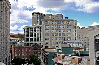
Downtown Grand Forks is the original commercial center of Grand Forks, North Dakota, United States. Located on the western bank of the Red River of the North, the downtown neighborhood is situated near the fork of the Red River and the Red Lake River. While downtown is no longer the dominant commercial area of the Greater Grand Forks community, it remains the historic center of Grand Forks. An 80.4-acre (32.5ha) portion was listed on the National Register of Historic Places in 2005, as Downtown Grand Forks Historic District. Today, downtown Grand Forks is home to many offices, stores, restaurants, and bars.
Third Street looking northThird Street looking south
Grand Forks was first settled in 1870. In 1872, seven pioneers staked claims to land on the Red River.[3] The 9-acre (36,000m2) piece of land that would become downtown Grand Forks was first platted by Grand Forks' "founding father", Alexander Griggs, and his wife Etta, in 1875. This was done in anticipation of the Saint Paul and Pacific Railroad (later the St. Paul, Minneapolis and Manitoba Railway and eventually the Great Northern Railway).[3] A collection of wood-frame buildings quickly sprouted up and, by 1880, the new city was home to 1,705 residents. The city was incorporated on February 22, 1881.
The coming of the Saint Paul, Minneapolis, and Manitoba Railway in 1880 led to dramatic growth. New multiple-story brick buildings replaced the old wood structures. The Hotel Dacotah, the St. John's Block, and the Security Building - all five stories - were witness to the fact that the city was prospering and that downtown Grand Forks was becoming one of the busiest commercial districts in the region. By the dawn of the 20th century, downtown Grand Forks had become the commercial, transportation, health care, entertainment, and cultural center of the region and boasted many amenities.
The 20th Century
Downtown Grand Forks, circa 1912DeMers Avenue
Throughout the early and mid parts of the 20th Century, downtown Grand Forks was easily the dominant commercial neighborhood in Grand Forks. In the later part of the century, the coming of the Interstate Highway System, urban renewal, and new commercial developments on the outskirts of the city signaled the start of a period of decline for downtown. Major shopping malls (South Forks Plaza in 1964 and Columbia Mall in 1978) relocated much of the commercial activity which had once been centered downtown. Over time, institutions which had once been a major part of downtown - the city's hospitals, post office, and public library - were replaced with new facilities outside of downtown.
A major downtown urban renewal project during the 1960s and 1970s saw the destruction of whole downtown blocks in favor of new office building, a city auditorium, and a new street overpass spanning the Grand Forks rail yards. Built in large part as a response to the new shopping malls in Grand Forks, the City Center Mall saw the blocking off of one whole block of South Third Street to vehicular traffic. A roof was built over the street and the entire one-block section became an indoor shopping center. The City Center mall was, in large part, a failure. The 1980s and 1990s saw little development taking place downtown. Indeed, several major businesses such as Griffith's Department Store, Norby's Department Store, and Silverman's clothing store either moved elsewhere within the city or shuttered their doors forever.
Flood of 1997
Simplified map of downtown Grand Forks
The Red River Flood of 1997 devastated downtown Grand Forks. The entire district was inundated with several feet of water and a major fire destroyed eleven historic buildings. An iconic image of the flood was the flooded and charred shell of the old five-story Security Building on North Third Street.
After the flood, a renewed effort was put into revitalizing downtown. A new Grand Forks Corporate Center was built in the center of downtown to replace office space which had been destroyed by the flood and fire. Remodeling of the old Empire Theater, which had been started before the flood, was completed and the building became known as the Empire Arts Center. The roof of the City Center Mall was removed and historic storefronts were once again visible. Other building projects following the flood included a new office building for the Grand Forks Herald, a new office building for Grand Forks County, a new "Town Square" community plaza, and the remodeling of countless downtown properties including the Metropolitan Opera House and the former First National Bank (now Alerus Financial) building.
Historic district
The Downtown Grand Forks Historic District is an 80.4-acre (32.5ha)historic district that was listed on the National Register of Historic Places in 2005. The area is also known as the Grand Forks Original Townsite and as the Central Business District.[2]
The National Register nomination includes some significant dates:[3]
1872, when settlers staked claims on the Red River
1875, when the town was platted
1880, when the Saint Paul, Minneapolis, and Manitoba Railway reached the city and was constructed through the center of downtown
1997, when the Red River flood covered all of downtown, and the resulting flood and fire damage brought significant destruction and then reconstruction
When listed, the district included 42 contributing buildings, four contributing structures, and 15 non-contributing buildings.[2] The area was surveyed in a 1981 study of Downtown Grand Forks historical resources. [1]
Downtown today
In recent years, a number of new stores and restaurants have opened up downtown. The city has recently been encouraging the construction of new apartments and condos in the downtown area. Several new and remodeled buildings offer upscale housing in stand-alone buildings or above businesses for varying prices.
Also, a farmer's market is held every Saturday (9AM to 2PM) from mid-June to mid-September in the Town Square on the corner of 3rd Street S. and DeMers Avenue.[4]
Grand Forks is a city in and the county seat of Grand Forks County, North Dakota, United States. The city's population was 59,166 as of the 2020 census, making it the third-most populous city in the state, after Fargo and Bismarck. Grand Forks, along with its twin city of East Grand Forks, Minnesota, forms the center of the Grand Forks metropolitan statistical area, which is often called Greater Grand Forks or the Grand Cities.
The North Loop is a neighborhood in the Central community of Minneapolis.
The Stone Arch Bridge is a former railroad bridge crossing the Mississippi River at Saint Anthony Falls in downtown Minneapolis, Minnesota. It is the only arched bridge made of stone on the entire Mississippi River. It is the second oldest bridge on the river next to Eads Bridge. The bridge was built to connect the railway system to the new Union Depot, which at that time was planned to be built between Hennepin Avenue and Nicollet Avenue. The bridge was completed in 1883, costing $650,000 at the time. 117 Portland Avenue is the general address of the historic complex.
Downtown Winnipeg is an area of Winnipeg located near the confluence of the Red and Assiniboine rivers. It is the oldest urban area in Winnipeg, and is home to the city's commercial core, city hall, the seat of Manitoba's provincial government, and a number of major attractions and institutions.
The Forks is a historic site, meeting place, and green space in downtown Winnipeg located at the confluence of the Red River and the Assiniboine River.
The Exchange District is a National Historic Site of Canada in the downtown area of Winnipeg, Manitoba, Canada. Just one block north of Portage and Main, the Exchange District comprises twenty city blocks and approximately 150 heritage buildings, and it is known for its intact early 20th century collection of warehouses, financial institutions, and early terracotta-clad skyscrapers.
Alerus Financial Corporation, marketed as simply Alerus, is a chain of financial institutions headquartered in Grand Forks, North Dakota, with locations in North Dakota, Minnesota and Arizona. Alerus offers banking, mortgage, wealth management, and retirement services.
The recorded history of Grand Forks in the U.S. state of North Dakota, began with the trade between Native Americans and French fur trappers during the 19th century. About 60 buildings or other historic sites in Grand Forks survive and are recognized among the National Register of Historic Places listings in Grand Forks County.
Downtown Santa Ana (DTSA), also called Downtown Orange County, is the city center of Santa Ana, the county seat of Orange County, California. It is the institutional center for the city of Santa Ana as well as Orange County, a retail and business hub.
The Main Street Historic District in Danbury, Connecticut, United States, is the oldest section of that city, at its geographical center. It has long been the city's commercial core and downtown. Its 132 buildings, 97 of which are considered contributing properties, include government buildings, churches, commercial establishments and residences, all in a variety of architectural styles from the late 18th century to the early 20th. It is the only major industrial downtown of its size in Connecticut not to have developed around either port facilities or a water power site.
The history of Winnipeg comprises its initial population of Aboriginal peoples through its settlement by Europeans to the present day. The first forts were built on the future site of Winnipeg in the 1700s, followed by the Selkirk Settlement in 1812. Winnipeg was incorporated as a city in 1873 and experienced dramatic growth in the late 19th and early 20th centuries. Following the end of World War I, the city's importance as a commercial centre in Western Canada began to wane. Winnipeg and its suburbs experienced significant population growth after 1945, and the current City of Winnipeg was created by the unicity amalgamation in 1972.
The Lower Woodward Avenue Historic District, also known as Merchant's Row, is a mixed-use retail, commercial, and residential district in downtown Detroit, Michigan, located between Campus Martius Park and Grand Circus Park Historic District at 1201 through 1449 Woodward Avenue and 1400 through 1456 Woodward Avenue. The district was listed on the National Register of Historic Places in 1999.
This is a list of the National Register of Historic Places listings in Grand Forks County, North Dakota. This is intended to be a complete list of the properties and districts on the National Register of Historic Places in Grand Forks County, North Dakota, United States. The locations of National Register properties and districts for which the latitude and longitude coordinates are included below, may be seen in an online map.
The Building at 201 S. 3rd St. is a property in Grand Forks, North Dakota that was listed on the National Register of Historic Places in 1982.
The Flatiron Building was an historic building in Grand Forks, North Dakota, that was built in 1906 and was destroyed by the 1997 Red River flood. It was listed on the National Register of Historic Places, but was removed from the Register in 2004 because it had been destroyed.
Dinnie Block was a property in Grand Forks, North Dakota. It was removed from the National Register of Historic Places in 2004.
The building at 205 DeMers Ave. is a property in Grand Forks, North Dakota that was listed on the National Register of Historic Places in 1982. It was destroyed by the 1997 Red River flood, and was officially delisted in 2018.
The First National Bank is a five-story building in Grand Forks, North Dakota, that was built in 1914–15 and listed on the National Register of Historic Places in 1982. It was built for the Scandinavian-American Bank, but has been identified as the First National Bank building since 1929.
The Williamston Downtown Historic District is a commercial historic district consisting of the first blocks of East and West Grand River Avenue, and the first block of South Putnam Street in Williamston, Michigan. The district was listed on the National Register of Historic Places in 2012.
7th Street is a street in Los Angeles, California running from S. Norton Ave in Mid-Wilshire through Downtown Los Angeles. It goes all the way to the eastern city limits at Indiana Ave., and the border between Boyle Heights, Los Angeles and East Los Angeles.
This page is based on this Wikipedia article Text is available under the CC BY-SA 4.0 license; additional terms may apply. Images, videos and audio are available under their respective licenses.