Drivers, Illinois | |
|---|---|
 Drivers  Drivers | |
| Coordinates: 38°19′50″N88°59′35″W / 38.33056°N 88.99306°W | |
| Country | United States |
| State | Illinois |
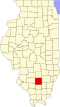
| County | Jefferson |
| Elevation | 440 ft (130 m) |
| Time zone | UTC-6 (Central (CST)) |
| • Summer (DST) | UTC-5 (CDT) |
| Area code | 618 |
| GNIS feature ID | 407395 [1] |
Drivers is an unincorporated community in Jefferson County, in the U.S. state of Illinois. [1]