Duke's Cut

Last updated

Duke's Cut
OxfordCanal Bridge232.jpg
Bridge 232, crossing the Duke's Cut
Location Wolvercote
CountryUnited Kingdom
Coordinates 51°47′29″N1°17′48″W / 51.79136°N 1.29675°W / 51.79136; -1.29675
Specifications
Length0.25 miles (0.40 km)
Minimum boat draft4 feet 11 inches (1.50 m) [1]
Locks1
StatusOpen
Navigation authorityCanal and River Trust
History
Original owner Duke of Marlborough
Date completed1789
Geography
DirectionWSW
Start pointWolvercote Junction, Oxford Canal [2]
End pointDuke's Cut Junction, Wolvercote Mill Stream [2]
Beginning coordinates 51°47′33″N1°17′37″W / 51.7924°N 1.2937°W / 51.7924; -1.2937
Ending coordinates 51°47′27″N1°17′57″W / 51.7908°N 1.2991°W / 51.7908; -1.2991
Branch of Oxford Canal
Connects to Oxford Canal, Wolvercote Mill Stream
Duke's Cut
Oxford Canal and Duke's Lock (44)
BSicon uCONTgq.svg
BSicon uLockl.svg
BSicon uFABZq+lr.svg
BSicon uCONTfq.svg
Oxford Canal to Oxford
BSicon uSKRZ-Eu.svg
Birmingham and Oxford Junction Railway
BSicon uLock3.svg
Duke's Cut Lock (44A)
BSicon uSTR.svg
BSicon uSKRZ-Au.svg
Northern Bypass (A40)
BSicon uSTR.svg
BSicon uDOCKS.svg
Duke's Lake
BSicon uSTR+l.svg
BSicon uxABZqr.svg
BSicon uexCONTfq.svg
To Wolvercote Mill
Wolvercote Mill Stream
BSicon uSTR.svg
River Thames
BSicon uCONTgq.svg
BSicon uFABZqlr.svg
BSicon uLockl.svg
BSicon uCONTfq.svg
King's Lock and River Thames

Duke's Cut is a short waterway in Oxfordshire, England, which connects the Oxford Canal with the River Thames via the Wolvercote Mill Stream. It is named after George Spencer, 4th Duke of Marlborough, across whose land the waterway was cut. It is seen as a branch of the Oxford Canal. [2]

Contents

History

The Cut was constructed at the request of the Duke of Marlborough. The Duchy of Marlborough had owned Wolvercote paper mill since 1720, and much of the surrounding land belonged to their Blenheim Palace estate. [3] In the 1790s, the Duke saw the benefit of bringing Warwickshire coal to the area, as the upper Thames area typically only received fuel from the Northumberland Coalfield via London, and consequently little cargo was left by the time vessels reached the upper river. [3] As owner of the land between the Oxford Canal and the mill stream, the Duke was aware of how level it was (and thus suited to a waterway) and permitted construction of a 500-yard (460 m) cut between the two waterways. The millstream provided a connection to the Thames above King's Weir, bypassing the flash lock. [1]

The cut opened in 1789; the exact date is unknown but an advertisement carried in William Jackson's Oxford Journal—published by the tenant of Wolvercote Mill [3] and printed on the mill's paper—showed that the cut had opened by 3 October. [1] It was conveyed in trust to the Vice-Chancellor of the University of Oxford and the Mayor of Oxford in 1792.

Adjacent to the cut is Duke's Lake, a reservoir also used for carp, roach, tench, and bream angling. [4]

Today, the cut is the preferred boating route from the Oxford Canal to the Thames; [5] the alternative route is at Oxford via and Isis Lock and the Sheepwash Channel. Until 1937, the latter was the only route between King's Lock and the lower Thames without having to navigate the flash lock at Medley Weir near Godstow Lock. [6]

Description

In 1802, Robert Mylne surveyed the cut and reported his findings to the Thames Commissioners. He described how the cut had a stop lock near Wolvercote Junction where it meets the canal; the beam of this was given as 13 feet 2 inches (4.01 m). [1] Bradshaw's Canals and Navigable Waterways of England and Wales (1904) noted that the lock gates were reversible to be usable regardless of which waterway was higher. [7] The canal usually discharged towards the Thames, [7] with an average pen of 1 foot (0.30 m), although when in flood, the Thames could rise to be up to 2 feet (0.61 m) above the canal. [1] The lock, known as Duke's Cut Lock, is designated 44A; [5] the numbering is inherited from that on the Oxford Canal. The lock is crossed by the Birmingham and Oxford Junction Railway, which opened in 1850. In 1987, the lock was granted Grade II listed status. [8]

At the junction with the mill stream, fed from the Thames, was a single gate of 12 feet 6 inches (3.81 m). Mylne stated that this floodgate was of poor seal and water easily flowed into the canal at times the river was of a higher level. [1]

In 1933, the Oxford–Witney road was constructed, and a large single-span skew arch bridge (designated 232U) was built across the cut. [9] The cut had a towing path along its north bank, which ran to the Thames in the west and connected with that of the Oxford Canal. [10] The towing path on the Oxford Canal crosses the cut by means of a brick arch bridge which also has Grade II listed status. [11]

At Duke's Cut Junction, a three-way Inland Waterways Association fingerpost sign provides navigational guidance, and shows that the Wolvercote Mill Stream below the junction was only for access to the mill. [12]

Related Research Articles

<span class="mw-page-title-main">Thames and Severn Canal</span> Canal in Gloucestershire in the south-west of England

The Thames and Severn Canal is a canal in Gloucestershire in the south-west of England, which was completed in 1789. It was conceived as part of a cargo route from Bristol and the Midlands to London, linking England's two largest rivers for better trade. The route climbs the steep Cotswold escarpment through the Golden Valley, tunnels underneath the summit of the Cotswold Edge, and emerges near the source of the Thames.

<span class="mw-page-title-main">Oxford Canal</span> Canal in England

The Oxford Canal is a 78-mile (126 km) narrowboat canal in southern central England linking the City of Oxford with the Coventry Canal at Hawkesbury via Banbury and Rugby. Completed in 1790, it connects to the River Thames at Oxford, and links with the Grand Union Canal, which it is combined with for 5 miles (8 km) between to the villages of Braunston and Napton-on-the-Hill.

<span class="mw-page-title-main">Napton on the Hill</span> Human settlement in England

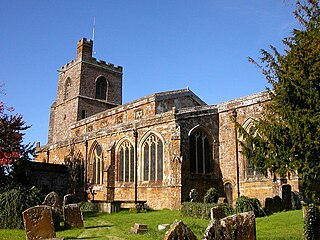
Napton on the Hill, often referred to locally as just Napton, is a village and civil parish 3 miles (4.8 km) east of Southam in Warwickshire, England. The population of the civil parish taken at the 2021 census was 1,416.

<span class="mw-page-title-main">History of the British canal system</span> Building, use, decline and restoration of artificial waterways in the United Kingdom

The canal network of the United Kingdom played a vital role in the Industrial Revolution. The UK was the first country to develop a nationwide canal network which, at its peak, expanded to nearly 4,000 miles in length. The canals allowed raw materials to be transported to a place of manufacture, and finished goods to be transported to consumers, more quickly and cheaply than by a land based route. The canal network was extensive and included feats of civil engineering such as the Anderton Boat Lift, the Manchester Ship Canal, the Worsley Navigable Levels and the Pontcysyllte Aqueduct.

<span class="mw-page-title-main">Lee Navigation</span> Canalised river in Hertfordshire and London, England

The Lee Navigation is a canalised river incorporating the River Lea. It flows from Hertford Castle Weir to the River Thames at Bow Creek; its first lock is Hertford Lock and its last Bow Locks.

<span class="mw-page-title-main">Eynsham</span> Village in Oxfordshire, England

Eynsham is an English village and civil parish in Oxfordshire, about 5 miles (8 km) north-west of Oxford and east of Witney. The 2011 Census recorded a parish population of 4,648. It was estimated at 5,087 in 2020.

<span class="mw-page-title-main">Cropredy</span> Human settlement in England

Cropredy is a village and civil parish on the River Cherwell, 4 miles (6.4 km) north of Banbury in Oxfordshire.

<span class="mw-page-title-main">Wolvercote</span> Human settlement in England

Wolvercote is a village that is part of the City of Oxford, England. It is about 3 miles (5 km) northwest of the city centre, on the northern edge of Wolvercote Common, which is itself north of Port Meadow and adjoins the River Thames.

<span class="mw-page-title-main">Godstow Bridge</span> Bridge in Godstow, Oxfordshire

Godstow Bridge is a road bridge across the River Thames in England at Godstow near Oxford. The bridge is just upstream of Godstow Lock on the reach to King's Lock and carries a minor road between Wolvercote and Wytham.

<span class="mw-page-title-main">Cassington</span> Human settlement in England

Cassington is a village and civil parish in Oxfordshire about 5 miles (8 km) northwest of Oxford. The village lies on gravel strata about 12 mile (800 m) from the confluence of the River Evenlode with the River Thames. The parish includes the hamlet of Worton northeast of the village and the site of the former hamlet of Somerford to the south. Somerford seems to have been abandoned early in the 14th century. Cassington is formed of two parts, "upper" and "lower", each with its own village green. The 2011 Census recorded the parish's population as 750.

<span class="mw-page-title-main">Osney Bridge</span> Bridge in Oxford

Osney Bridge is a road bridge across the River Thames in Oxford, England, built in 1888 to replace a stone bridge which collapsed in 1885. It carries the Botley Road (A420) from Botley into Oxford. The Thames Path crosses the river on this bridge, just above Osney Lock.

<span class="mw-page-title-main">Osney Lock</span> Lock on the River Thames in Oxfordshire, England

Osney Lock is a lock on the River Thames in Oxford, England, where the village or island of Osney is next to the river.

<span class="mw-page-title-main">Godstow Lock</span> Lock on the River Thames in Oxfordshire, England

Godstow Lock is a lock on the River Thames in Oxfordshire, England. It is between the villages of Wolvercote and Wytham on the outskirts of Oxford. The first lock was built of stone by Daniel Harris for the Thames Navigation Commission in 1790. It is the lock furthest upstream on the river which has mechanical (electro-hydraulic) operation - every lock upstream of Godstow utilises manual beam operation instead.

<span class="mw-page-title-main">King's Lock</span> Lock on the River Thames in Oxfordshire, England

King's Lock is a lock on the River Thames in England. It is in open country to the north of Oxford, Oxfordshire, on the southern bank of the river. The lock was one of the last pound locks built on the Thames, built by the Thames Conservancy in 1928 to replace the former flash lock. It has the smallest fall of any lock on the river, 0.77 m.

<span class="mw-page-title-main">A34 Road Bridge</span> Bridge in Oxford

The A34 Road Bridge is a modern road bridge carrying the Oxford ring road at Oxford, England, across the River Thames. It crosses the Thames just upstream of Godstow Lock near Wolvercote on the reach to King's Lock. The bridge was built in 1961.

Thrupp is a hamlet just north of Kidlington in Oxfordshire. It is beside the Oxford Canal and close to the River Cherwell.

<span class="mw-page-title-main">Hackney Cut</span> Canal in East London

The Hackney Cut is an artificial channel of the Lee Navigation built in England in 1769 by the River Lea Trustees to straighten and improve the Navigation. It begins at the Middlesex Filter Beds Weir, below Lea Bridge, and is situated in the (modern) London Borough of Hackney. When built it contained two pound locks and a half-lock, but was rebuilt to handle larger barges in the 1850s, and now only Old Ford Lock, which is actually a duplicated pair, remains.

Daniel Harris was an English builder, prison governor, civil engineer, and architect prominent in Oxford.

<span class="mw-page-title-main">Cassington Canal</span> Canal in Oxfordshire

The Cassington Canal was an early 19th-century canal near Eynsham, Oxfordshire. The canal was built by the 4th Duke of Marlborough to provide a link between the River Thames and Cassington Mill; it later provided alternative wharfage to that at Eynsham. The 0.75-mile (1.21 km) canal was in operation for less than 70 years, its use declining with the advent of rail transport.

<span class="mw-page-title-main">Port Meadow with Wolvercote Common and Green</span>

Port Meadow with Wolvercote Common and Green is a 167.1-hectare (413-acre) biological Site of Special Scientific Interest in Oxford in Oxfordshire. It is a Nature Conservation Review site, Grade I, and part of Oxford Meadows Special Area of Conservation. The remains of Godstow Abbey, which is a Scheduled Monument, are in the north of the site.

References

  1. 1 2 3 4 5 6 Compton, Hugh J (1976). The Oxford Canal. Newton Abbot: David & Charles. p. 52. ISBN   0-7153-7238-6.
  2. 1 2 3 "Waterway Gazetteer for Oxford Canal (Duke's Cut)". canalplan.org.uk. CanalPlanAC. Retrieved 10 January 2020.
  3. 1 2 3 Compton, Hugh J (1976). The Oxford Canal. Newton Abbot: David & Charles. p. 51. ISBN   0-7153-7238-6.
  4. Whyte, Abigail (19 June 2015). "Angling on the cut". Waterfront. Canal and River Trust. Retrieved 10 January 2020.
  5. 1 2 Zucchelli, Anna. "DESIGN, ACCESS AND HERITAGE STATEMENT OXFORD CANAL – WOLVERCOTE DUKE'S CUT LOCK (LOCK 44A)". Canal and River Trust. Retrieved 9 January 2020.[ dead link ]
  6. Eade, John. "GODSTOW LOCK - (WHERE THAMES SMOOTH WATERS GLIDE)". thames.me.uk. Retrieved 10 January 2020.
  7. 1 2 Henry Rodolph de Salis (November 2012). Bradshaw's Canals and Navigable Rivers of England and Wales. BoD – Books on Demand. pp. 305–. ISBN   978-3-95427-214-3.
  8. Historic England. "OXFORD CANAL DUKE'S CUT LOCK (1370051)". National Heritage List for England . Retrieved 9 January 2020.
  9. Compton, Hugh J (1976). The Oxford Canal. Newton Abbot: David & Charles. p. 89. ISBN   0-7153-7238-6.
  10. "OS 25 inch Scotland, 1892-1949 England and Wales, 1841-1952". maps.nls.uk. National Library of Scotland. Retrieved 9 January 2020.
  11. Historic England. "OXFORD CANAL TOWPATH BRIDGE AT DUKE'S CUT LOCK (1286500)". National Heritage List for England . Retrieved 9 January 2020.
  12. Eade, John. "OXFORD CANAL - (WHERE THAMES SMOOTH WATERS GLIDE)". thames.me.uk. Retrieved 10 January 2020.
Next confluence upstream River Thames Next confluence downstream
River Evenlode (north)Duke's Cut Bulstake Stream (south)