Dun Law (Scottish Borders)

Last updated

Dun Law
Highest point
Elevation 393 m (1,289 ft)
Coordinates 55.808414, -2.862749
Naming
English translation Scottish Gaelic, Scots: Fort Hill [1] [2]
Geography
Location Scottish Borders, Scotland
Parent range Lammermuir Hills, Southern Uplands
OS grid NT 460 576

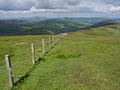
Dun Law is a hill in the Scottish Borders. It lies between Fala and Carfraemill, just to the south of Soutra Aisle, at the western end of the Lammermuir Hills.The hill rises to 393 m (1289 feet). [3] There is a historic quarry on the north side of the hill, [4] possible Bronze Age house platforms on its east side [5] and a cairn on its summit. [6]

Contents

Wind Farm

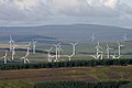
Dun Law Windfarm is on the hill and became operational in 2000 with 26 Vestas turbines that can generate up to 17 megawatts of power. The windfarm was extended, starting in 2007, with an additional 35 turbines, all installed by November 2009, for an additional 30 megawatts of capacity. In total, it can produce up to 47 megawatts of electricity. It is estimated that it will be decommissioned in 2034. [7]

The Dun Law Extension Community Benefit Trust administers the community funds provided by wind farm. Grants are given by the Trust to enhance the quality of life in the surrounding communities. [8]

Archaeology

Excavations in 2007, by CFA Archaeology, in advance of the construction of a wind farm access road, uncovered a section of the Dere Street Roman road. Dere Street was built in the late 1st century AD to enable the advance of the Roman Army into what is now Scotland. It runs from the Roman legionary forts of Eburacum (York) and Inchtuthil near Perth. The excavations discovered that this section of the road was laid over a palaeochannel using a latticework of logs and a mat of branchwood. There are only a handful examples of such engineering work in Roman road construction. The archaeologists found that the wood used was locally sourced from the then depleted forests. [9]

Examination of the pollen in peat samples, taken during the excavations, from under the road allowed the archaeologists to reconstruct, roughly, the environment of the area from roughly 2500BC to the construction of the road. They found that the area was forested until sometime between 700 BC - 1AD when the area was significantly cleared of forests. There were very few trees in the area when the road was constructed and that construction cleared the rest of them. [9]

Soutra Aisle

Just to the north of the hill is Soutra Aisle, the remains of the House of the Holy Trinity, a church that was part of a complex comprising a hospital and a friary.

Images

Related Research Articles

Broch Type of Iron Age drystone hollow-walled structure

A broch is an Iron Age drystone hollow-walled structure found in Scotland. Brochs belong to the classification "complex Atlantic roundhouse" devised by Scottish archaeologists in the 1980s. Their origin is a matter of some controversy.

Avebury Neolithic henge monument in Wiltshire, England

Avebury is a Neolithic henge monument containing three stone circles, around the village of Avebury in Wiltshire, in southwest England. One of the best known prehistoric sites in Britain, it contains the largest megalithic stone circle in the world. It is both a tourist attraction and a place of religious importance to contemporary pagans.

Lammermuir Hills Range of hills in southern Scotland

The Lammermuirs are a range of hills in southern Scotland, forming a natural boundary between East Lothian and the Borders.

Dere Street Roman road that ran from York in England to the Antonine Wall in Scotland

Dere Street or Deere Street is a modern designation of a Roman road which ran north from Eboracum (York), crossing the Stanegate at Corbridge and continuing beyond into what is now Scotland, later at least as far as the Antonine Wall. Portions of its route are still followed by modern roads, including the A1, the B6275 road through Piercebridge, where Dere Street crosses the River Tees, and the A68 north of Corbridge in Northumberland.

Kintore, Aberdeenshire Human settlement in Scotland

Kintore is a town and former royal burgh near Inverurie in Aberdeenshire, Scotland, now bypassed by the A96 road between Aberdeen and Inverness. It is situated on the banks of the River Don.

Breasclete Village in the Outer Hebrides, Scotland

Breasclete is a village and community on the west side of the Isle of Lewis, in the Outer Hebrides, Scotland. Breasclete is within the parish of Uig, and is situated adjacent to the A858.

Newbridge, Edinburgh Human settlement in Scotland

Newbridge is a village within the parish of Kirkliston, to the west of Edinburgh, Scotland. It originally lay on the western edge of the county of Midlothian; however, local government reforms in the late 20th century placed it within the jurisdiction of the City of Edinburgh Council.

Fala, Midlothian Human settlement in Scotland

Fala is a hamlet in the south-eastern corner of Midlothian, Scotland, and about 15 miles from Edinburgh.

Wind power in Scotland Overview of wind power in Scotland

Wind power in Scotland is the fastest-growing renewable energy technology, with 9,347 MW of installed wind power capacity as of June 2020. This included 8,366 MW from onshore wind in Scotland and 981 MW of offshore wind generators.

Whitelee Wind Farm

Whitelee Wind Farm is a windfarm on the Eaglesham moor in Scotland. The main visitor centre is located in East Renfrewshire, but the majority of turbines are located in East Ayrshire and South Lanarkshire. It is the largest on-shore wind farm in the United Kingdom with 215 Siemens and Alstom wind turbines and a total capacity of 539 megawatts (MW), with the average of 2.5 MW per turbine. Whitelee was developed and is operated by ScottishPower Renewables, which is part of the Spanish company Iberdrola.

Lauderdale Geographical district in the Scottish Borders, Scotland

Lauderdale is a long narrow geographical district in the Scottish Borders, Scotland, being the valley of the Leader Water,, above which rivulet St. Cuthbert had a vision of St. Aidan's soul being conducted to heaven. It is traversed from end to end by the A68 trunk road which runs from Darlington to Edinburgh.

Vindomora Roman auxiliary fort in County Durham, England

Vindomora was an auxiliary fort on Dere Street, in the province of Lower Britain. Its ruins, now known as Ebchester Roman Fort, are situated at Ebchester in the English county of Durham, to the north of Consett and 12 miles (19 km) west-south-west from Newcastle upon Tyne.

South Dell Human settlement in Scotland

South Dell is a village on the Isle of Lewis in the community of Ness, in the Outer Hebrides, Scotland. South Dell is within the parish of Barvas, and is situated alongside the A857. The Dell River separates South and North Dell. The artists David Greenall and Ruth O'Dell live in South Dell.

Neart Na Gaoithe is an offshore wind farm under construction in the outer Firth of Forth, 30 kilometres (19 mi) north of Torness. It has a potential capacity of 450 MW. It is being developed by Mainstream Renewable Power at a cost of £1.4bn. Offshore work began in 2020, with completion planned for 2023.

Inveresk Roman Fort Archaeological site in East Lothian, Scotland

Inveresk Roman Fort is an archaeological site within the grounds of St Michael's Church, Inveresk, a village in East Lothian, Scotland.

Dun Mor Vaul

Dun Mor Vaul is an iron-age broch located on the north coast of the island of Tiree, in Scotland.

Whitehill, Midlothian Human settlement in Scotland

Whitehill is a village in Midlothian in the south-east of Scotland, approximately 1.5 miles (2 km) south-east of Dalkeith and 8.5 miles (13.6 km) from Edinburgh. The village is situated on the northwest slope of the Mayfield-Tranent ridge which spans the border between Midlothian and East Lothian. Both road entrances to the village offer magnificent panoramic views over Edinburgh, the Firth of Forth and the Pentland Hills.

St Marys Star of the Sea Church, Leith Church in Edinburgh, United Kingdom

St Mary Star of the Sea (Leith) Church is a Roman Catholic parish church in Edinburgh, Scotland. It is situated on Constitution Street in the Leith district and staffed by the Missionary Oblates of Mary Immaculate.

References

  1. "dùn". Wiktionary. 14 October 2019.
  2. "Dictionaries of the Scots Language:: DOST :: Law n 2".
  3. "Dun Law from The Gazetteer for Scotland". www.scottish-places.info. Retrieved 25 October 2021.
  4. "Dun Law | Canmore". canmore.org.uk. Retrieved 25 October 2021.
  5. "Dun Law | Canmore". canmore.org.uk. Retrieved 25 October 2021.
  6. "Dun Law | Canmore". canmore.org.uk. Retrieved 25 October 2021.
  7. "Dun Law Windfarm". ScottishPower Renewables. Retrieved 25 August 2021.
  8. "Dun Law Trust". www.dunlaw.org. Retrieved 25 August 2021.
  9. 1 2 "Vol 57 (2014): Excavation across the Dere Street Roman Road at Dun Law, Scottish Borders | Scottish Archaeological Internet Reports". journals.socantscot.org. Retrieved 25 August 2021.