Dunagiri (mountain)

Last updated

Dunagiri
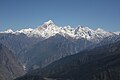
Dunagiri from Kuari Pass.jpg
Dunagiri from the Kuari Pass
Highest point
Elevation 7,066 m (23,182 ft)
Prominence c. 1,200 m (3,900 ft) [1]
Coordinates 30°31′57″N79°50′02″E / 30.53250°N 79.83389°E / 30.53250; 79.83389
Geography
India Uttarakhand relief map.svg
Red triangle with thick white border.svg
Dunagiri
Location in Uttarakhand, India
Location Uttarakhand, India
Parent range Nanda Devi Group, Garhwal Himalayas
Climbing
First ascent 5 July 1939 by André Roch, F. Steuri, D. Zogg [2]
Easiest route southwest ridge: rock/snow/ice climb

Dunagiri (7,066 m) is one of the high peaks of the Chamoli District Himalayas in the northern Indian state of Uttarakhand. It lies at the northwest corner of the Sanctuary Wall, a ring of peaks surrounding Nanda Devi and enclosing the Nanda Devi Sanctuary.

Contents

In Hindu mythology

According to Ramayana , Sanjeevani is a magical herb that has the power to cure serious nervous system problems. It was believed that medicines prepared from this herb could revive someone when death was almost certain. The herb is mentioned in the Ramayana when Ravana's son Indrajit (Meghnada) hurls a powerful weapon at Lakshmana. Lakshmana is badly wounded and is nearly killed. Hanuman was called upon to fetch this herb from Mount Dronagiri (Mahodaya) or the Gandhamardhan hills, far to the north of the Vindhyas on the slopes of the Himalayas. The mountain of herbs is identified as the Valley of Flowers near Badri in Uttarakhand on the slopes of the Himalayas. It is sometimes called Gandhamardan, and at other times Dronagiri. Upon reaching Dronagiri Parvata or Gandhamardan, Hanuman could not identify the herb and lifted the whole mountain and brought it to the battlefield. [3]

History

Dunagiri was first climbed on 5 July 1939 [4] by the Swiss climbers André Roch, F. Steuri and D. Zogg, via the southwest ridge. In 1975, Joe Tasker and Dick Renshaw climbed a particularly difficult route on the southeast buttress in a significant milestone for alpine-style climbing. [5] In 1978 the first Australian Himalayan expedition by the Australian National University Mountaineering Club made the fourth ascent via the south-west ridge. [6] Lincoln Hall and Tim Macartney-Snape made the final summit attempt with Macartney-Snape successfully summiting.

Related Research Articles

<span class="mw-page-title-main">Nanda Devi</span> Second-highest mountain in India

Nanda Devi is the second-highest mountain in India, after Kangchenjunga, and the highest located entirely within the country. Nanda Devi is the 23rd-highest peak in the world.

<span class="mw-page-title-main">Tirsuli</span>

Tirsuli is a Himalayan mountain peak in the Chamoli district of Uttarakhand, India. It is part of the complex of mountains, including Tirsuli West, Hardeol, Dunagiri, Changabang, and Kalanka, which make up the northeast wall of the Nanda Devi Sanctuary, in the Garhwal Himalaya. It rises at the northern end of the Johar Valley, which drains into the Ghori Ganga. This peak should not be confused with nearby Trisul, which is on the southwest side of the Sanctuary.

<span class="mw-page-title-main">Hardeol</span> Mountain in India

Hardeol or 'Temple of God' is one of the major peaks of the Kumaon Himalaya. It is the highest peak on the northern side of the ring of peaks guarding the Nanda Devi Sanctuary, and lies at the northeast corner of this ring. It is situated at the northern end of the Milam valley, in the Pithoragarh district of Uttarakhand, India. To its immediate north lies Trishuli, and just south is Rishi Pahar, on a north-south trending ridge leading eventually to Nanda Devi East. Hardeol is also known as Trishuli South.

Tim Macartney-Snape is an Australian mountaineer and author. On 3 October 1984 Macartney-Snape and Greg Mortimer were the first Australians to reach the summit of Mount Everest. They reached the summit, climbing without supplementary oxygen, via a new route on the North Face. In 1990, Macartney-Snape became the first person to walk and climb from sea level to the top of Mount Everest. Macartney-Snape is also the co-founder of the Sea to Summit range of outdoor and adventure gear and accessories, a guide for adventure travel company World Expeditions and a founding director and patron of the World Transformation Movement.

<span class="mw-page-title-main">Nanda Kot</span>

Nanda Kot is a mountain peak of the Himalaya range located in the Pithoragarh district of Uttarakhand state in India. It lies in the Kumaon Himalaya, just outside the ring of peaks enclosing the Nanda Devi Sanctuary, 15 kilometres (9 mi) southeast of Nanda Devi itself. The name Nanda Kot literally means "Nanda's Fortress" and refers to the abode of one of the sacred forms of the Hindu Goddess Parvati who in legend has made her sanctuary amongst the ring of lofty mountains in the region.

Rishi Pahar is a Himalayan mountain peak, located in the Pithoragarh district of Uttarakhand state in India. It lies at the northeast corner of the ring of peaks surrounding the Nanda Devi Sanctuary, and on the eastern rim of the Nanda Devi Biosphere Reserve, just south of Trishuli and Hardeol. The Milam Glacier lies on its east flank. It marks the triple divide between the Milam, Dunagiri, and Uttari Rishi Ganga valleys. Rishi Pahar means 'The Peak of Saint' in Hindi.

The Nanda Devi National Park or Nanda Devi Biosphere Reserve, established in 1982 is a national park situated around the peak of Nanda Devi in Chamoli Garhwal district of Uttarakhand, in northern India. The entire park lies at an elevation of more than 3,500 m (11,500 ft) above mean sea level.

Tirsuli West, or Trishuli West, is a Himalayan mountain peak in the Chamoli district of Uttarakhand, India. It is part of the complex of mountains, including Tirsuli, Hardeol, Dunagiri, Changabang, and Kalanka, which make up the northeast wall of the Nanda Devi Sanctuary, in the Garhwal Himalaya. It lies very near both Tirsuli and Hardeol at the north end of the Johar Valley.

<span class="mw-page-title-main">Trisul</span> Mountain in Uttarakhand, india

Trisul is a group of three Himalayan mountain peaks of western Kumaun, Uttarakhand, with the highest reaching 7120m. The three peaks resemble a trident - in Sanskrit, Trishula, trident, is the weapon of Shiva. The Trishul group forms the southwest corner of the ring of peaks enclosing the Nanda Devi Sanctuary, about 15 kilometres (9 mi) west-southwest of Nanda Devi itself. The main peak, Trisul I, was the first peak over 7,000 m (22,970 ft) to have ever been climbed, in 1907.

<span class="mw-page-title-main">Nilkantha (mountain)</span> Mountain in Uttarakhand, India

Nilkantha is a major peak of the Garhwal division of the Himalayas, in the Uttarakhand region of the Indian state of Uttarakhand. Although substantially lower than the highest peaks of the region, it towers dramatically over the valley of the Alaknanda River and rises 3,474 metres (11,398 ft) above the Hindu pilgrimage site of Badrinath, only 9 km (6 mi) to the east. Frank Smythe described the peak as "second only to Siniolchu in Himalayan beauty."

<span class="mw-page-title-main">William Woodman Graham</span> British mountaineer

William Woodman Graham was a British mountaineer who led the first pure mountaineering expedition to the Himalayas and may have set a world altitude record on Kabru. Motivated by adventure rather than a desire for fame, he had little interest in publicising his climbs, and as a result relatively little is known about his life and achievements.

<span class="mw-page-title-main">Geography of Uttarakhand</span>

Uttarakhand has a total geographic area of 53,483 km2, of which 86% is mountainous and 65% is covered by forest. Most of the northern parts of the state are part of Greater Himalaya ranges, covered by the high Himalayan peaks and glaciers, while the lower foothills were densely forested till denuded by the British log merchants and later, after independence, by forest contractors. Recent efforts in reforestation, however, have been successful in restoring the situation to some extent. The unique Himalayan ecosystem plays host to many animals, plants and rare herbs. Two of India's great rivers, the Ganges and the Yamuna take birth in the glaciers of Uttarakhand, and are fed by myriad lakes, glacial melts and streams.

<span class="mw-page-title-main">Sunanda Devi</span>

Nanda Devi East, locally known as Sunanda Devi, is the lower of the two adjacent peaks of the highest mountain in Uttarakhand and second highest mountain in India; Nanda Devi is its higher twin peak. Nanda Devi and Nanda Devi East are part of the Garhwal Himalayas, and are located in the state of Uttarakhand. The two peaks are visible from almost everywhere in Kumaon. The first ascent of Nanda Devi East peak was probably in 1939 by Jakub Bujak and Janusz Klarner. The elevation of Nanda Devi East is 7,434 m (24,390 ft) and its prominence is 260 m (850 ft).

<span class="mw-page-title-main">Shipton–Tilman Nanda Devi expeditions</span> Himalayan mountaineering expeditions in 1930s

The Shipton–Tilman Nanda Devi expeditions took place in the 1930s. Nanda Devi is a Himalayan mountain in what was then the Garhwal District in northern India, just west of Nepal, and at one time it was thought to be the highest mountain in the world.

<span class="mw-page-title-main">Sanjivani (Hinduism)</span> Medicinal herb in Hinduism

Sanjivani or the Mrtasanjivani is a medicinal herb featured in the Hindu epic Ramayana.

The role of The Doon School in Indian mountaineering describes the formative links between The Doon School, an all-boys boarding school in Dehradun, India and early post-Independence Indian mountaineering. From the 1940s onwards, Doon's masters and students like A.E. Foot, R.L. Holdsworth, J.A.K. Martyn, Gurdial Singh, Jack Gibson, Aamir Ali, Hari Dang, Nandu Jayal, were among the first to go on major Himalayan expeditions in a newly independent nation. These early expeditions contributed towards laying the foundation of mountaineering in an independent India.

Saf Minal is a mountain of Garhwal Himalaya in Uttarakhand India. Saf Minal standing majestically at 6911 meter 22674 feet. It's the 21st highest located entirely within the uttrakhand India. Nanda Devi, is the highest mountain in this category and 50th highest peak in India. Saf Minal is the 332nd highest peak in the world. Saf Minal falls on the edge of the Northern Nanda Devi National Park.

Rishi Kot is a mountain of the Garhwal Himalaya in Uttarakhand India. Rishi Kot means “the Rishis’ fortress”. The elevation of Rishi Kot is 6,236 metres (20,459 ft) and its prominence is 436 metres (1,430 ft). It is 134th joint highest located entirely within the Uttrakhand. Nanda Devi, is the highest mountain in this category. It lies 5.7 km SW of Changabang 6,864 metres (22,520 ft) its nearest higher neighbor and 7.1 km south of Dunagiri 7,066 metres (23,182 ft). Bethartoli 6,393 metres (20,974 ft) lies 13.4 km SW and 11.7 km SSE lies Nanda Devi 7,816 metres (25,643 ft).

References

  1. This is an approximate figure, based on the 1:150,000 scale topographic map Garhwal-Himalaya-Ost, Swiss Foundation for Alpine Research.
  2. Jill Neate (1989). High Asia: An Illustrated History of the 7000 Metre Peaks. ISBN   0-89886-238-8.
  3. "Peaks that became temples". The Hindu. 16 March 2017. Retrieved 1 December 2020.
  4. Some sources say 1947.
  5. Andy Fanshawe and Stephen Venables, Himalaya Alpine-Style, Hodder and Stoughton, 1995, ISBN   0-340-64931-3
  6. Steffen, Will (2010). Himalayan Dreaming: Australian mountaineering in the great ranges of Asia 1922-1990. Canberra: ANU E Press. p. 593. ISBN   978-1-921666-16-2.