
The Metropolitan Borough of Doncaster is a metropolitan borough of South Yorkshire in Yorkshire and the Humber Region of England.

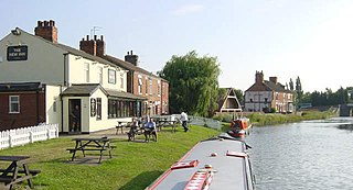
Hatfield is a town and civil parish in the Metropolitan Borough of Doncaster in South Yorkshire, England. It had a population of 17,236 at the 2011 Census. The town is located to the west of the M18 motorway and has a railway station on the line between Goole/Scunthorpe and Doncaster. Recorded history in the parish extends as far back as 730, when Bede wrote about the Northumbrian King, Edwin, being killed in battle in the area.

The Axholme Joint Railway was a committee created as a joint enterprise between the Lancashire and Yorkshire Railway (L&Y) and the North Eastern Railway (NER) and was established by the North Eastern Railway Act of 31 July 1902. It took over the Goole and Marshland Railway, running from Marshland Junction near Goole to Reedness Junction and Fockerby, and the Isle of Axholme Light Railway, running from Reedness Junction to Haxey Junction. Construction of the Goole and Marshland Railway had begun in 1898, and by the time of the takeover in early 1903, was virtually complete. The Isle of Axholme Light Railway was started in 1899, but only the section from Reedness Junction to Crowle was complete at the takeover. The northern section opened on 10 August 1903, and the line from Crowle to Haxey Junction opened for passengers on 2 January 1905.
Stainforth is a town and civil parish in the Metropolitan Borough of Doncaster, in South Yorkshire, England. It is around 7 miles (11 km) north-east of Doncaster, close to Hatfield and Thorne. It had a population of 6,342 in the 2001 census, reducing slightly to 6,282 at the 2011 census.
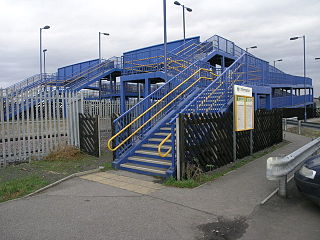
Hatfield and Stainforth railway station serves the towns of Hatfield and Stainforth in South Yorkshire, England. It is located 6+3⁄4 miles (10.9 km) north east of the main Doncaster station.

Thorne South railway station is one of two stations serving the ex-mining town of Thorne in South Yorkshire, England. The station is 9.75 miles (16 km) north of Doncaster on the South Humberside Main Line. It is unstaffed, and the only passenger facilities are standard shelters on each platform.

The A18 is a road in England that links Doncaster in South Yorkshire with Ludborough in Lincolnshire, via Scunthorpe and Grimsby. Much of its route has been superseded by the M180 motorway.

Hatfield Main F.C. was an English football club in Hatfield, South Yorkshire.

Little Hatfield is a small hamlet in the East Riding of Yorkshire, England, in an area known as Holderness. It is situated approximately 3 miles (5 km) south-west of Hornsea town centre, and less than 1 mile (1.6 km) west of Great Hatfield.
Great Hatfield is a village in the East Riding of Yorkshire, England in an area known as Holderness. It is situated approximately 3.5 miles (5.6 km) south-west of Hornsea town centre, and less than 1 mile (1.6 km) east of Little Hatfield.

In architecture, a long gallery is a long, narrow room, often with a high ceiling. In Britain, long galleries were popular in Elizabethan and Jacobean houses. They were often located on the upper floor of the great houses of the time, and they stretched across the entire frontage of the building. They served several purposes: they were used for entertaining guests, for taking exercise in the form of walking when the weather was inclement, and for displaying art collections.

Hatfield is a civil parish in the East Riding of Yorkshire, England. It is situated 3 miles (5 km) to the south-west of Hornsea town centre and covering an area of 1,336.789 hectares.

HM Prison Hatfield is a Category D men's prison and Young Offenders Institution, located near Hatfield Woodhouse in South Yorkshire, England. The prison is operated by Her Majesty's Prison Service

Hatfield Colliery, also known as Hatfield Main Colliery, was a colliery in the South Yorkshire Coalfield, mining the High Hazel coal seam. The colliery was around 1 mile (1.6 km) northwest of Hatfield, South Yorkshire, adjacent north of the railway line from Doncaster to Scunthorpe northeast of Hatfield and Stainforth railway station.

Thorne and Hatfield Moors Peat Canals were a series of canals in South Yorkshire and Lincolnshire, England, which were used to carry cut peat from Thorne and Hatfield Moors to points where it could be processed or exported. There were two phases to the canals, the first of which lasted from the 1630s until the 1830s, when coal imported on the Stainforth and Keadby Canal reduced the demand for peat as a fuel. The second started in the 1890s, when peat found a new use as bedding for working horses, and lasted until 1922, when Moorends Mill which processed the peat was destroyed by fire.
The 1982–83 Northern Counties East Football League season was the first in the history of Northern Counties East Football League, a football competition in England. The league was formed by the merger of the Midland League and the Yorkshire League.
The 1963–64 Yorkshire Football League was the 38th season in the history of the Yorkshire Football League, a football competition in England. At the end of the season Division Three was disbanded.

