Dusty, Washington

Last updated

Dusty, Washington
Entering Dusty, WA.jpg
Entering Dusty Sign
Dusty, Washington
Coordinates: 46°48′37″N117°39′07″W / 46.81028°N 117.65194°W / 46.81028; -117.65194
CountryUnited States
State Washington
County Whitman
Time zone UTC-8 (PST)
  Summer (DST) UTC-7 (PDT)
Zip Code
99143
Area code 509

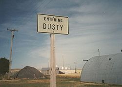
Dusty is an unincorporated community in Whitman County, Washington, United States. [1] It lies at the junction of Washington State Route 26 and Washington State Route 127.

Contents

Geography

Whitman County, Washington near Dusty WhitmanCountyWA.jpg
Whitman County, Washington near Dusty

The community is located in the Palouse Region, which is known for its rolling hills and agricultural production. Various reports put the population of this tiny hamlet at either 11 or 12 people and 2 horses (+/- a horse).

Notable residents

Dusty is home of Wylie Gustafson, leader of the musical group Wylie & The Wild West. Coming from an extremely small community, this group has performed at the National Cowboy Poetry Gathering, The National Folk Festival, Kennedy Center, Lincoln Center, on A Prairie Home Companion , the National Lentil Festival and on the Grand Ole Opry . [2] [3]

Related Research Articles

<span class="mw-page-title-main">Whidbey Island</span> Island in Puget Sound in Washington, United States

Whidbey Island is the largest of the islands composing Island County, Washington, in the United States, and the largest island in Washington state. Whidbey is about 30 miles (48 km) north of Seattle, and lies between the Olympic Peninsula and the I-5 corridor of western Washington. The island forms the northern boundary of Puget Sound. It is home to Naval Air Station Whidbey Island. The state parks and natural forests are home to numerous old growth trees.

<span class="mw-page-title-main">Lexington, Kentucky</span> City in Kentucky, United States

Lexington is the second-most-populous city in the Commonwealth of Kentucky, and the 60th-most populous city in the United States. It is the county seat of Fayette County. By land area, it is the country's 30th-largest city.

<span class="mw-page-title-main">Benton County, Washington</span> County in Washington, United States

Benton County is a county in the south-central portion of the U.S. state of Washington. As of the 2020 census, its population was 206,873. The county seat is Prosser, and its largest city is Kennewick. The Columbia River demarcates the county's north, south, and east boundaries.

<span class="mw-page-title-main">Fairfax County, Virginia</span> County in Virginia, United States

Fairfax County, officially the County of Fairfax, is a county in the Commonwealth of Virginia. It is part of Northern Virginia and borders both the city of Alexandria and Arlington County and forms part of the suburban ring of Washington, D.C. The county is predominantly suburban in character with some urban and rural pockets.

<span class="mw-page-title-main">Caroline County, Virginia</span> County in Virginia, United States

Caroline County is a United States county located in the eastern part of the Commonwealth of Virginia. The northern boundary of the county borders on the Rappahannock River, notably at the historic town of Port Royal. The Caroline county seat is Bowling Green.

<span class="mw-page-title-main">Bushnell, Illinois</span> City in Illinois, United States

Bushnell is a city in McDonough County, Illinois, United States. The population was 2,718 at the 2020 census, down from 3,117 in 2010.

<span class="mw-page-title-main">Logan, Utah</span> City in Utah, United States

Logan is a city in Cache County, Utah, United States. The 2020 census recorded the population was 52,778. Logan is the county seat of Cache County and the principal city of the Logan metropolitan area, which includes Cache County and Franklin County, Idaho. The Logan metropolitan area contained 125,442 people as of the 2010 census and was declared by Morgan Quitno in 2005 and 2007 to be the safest in the United States in those years. Logan also is the location of the main campus of Utah State University.

<span class="mw-page-title-main">Port Townsend, Washington</span> City in Washington, United States

Port Townsend is a city on the Quimper Peninsula in Jefferson County, Washington, United States. The population was 10,148 at the 2020 United States Census. It is the county seat and only incorporated city of Jefferson County.

<span class="mw-page-title-main">Omak, Washington</span> City in Washington, United States

Omak is a city located in the foothills of the Okanogan Highlands in north-central Washington, United States. With an estimated 4,845 residents as of 2010, distributed over a land area of 3.43 square miles (8.9 km2), Omak is the largest municipality of Okanogan County and the largest municipality in Central Washington north of Wenatchee. The Greater Omak Area of around 8,229 inhabitants as of the 2010 census is the largest urban cluster in the Okanogan Country region, encompassing most of its twin city of Okanogan. The population has increased significantly since the 1910 census, reporting 520 residents just prior to incorporation in 1911.

<span class="mw-page-title-main">Sioux Falls, South Dakota</span> City in South Dakota, United States

Sioux Falls is the most populous city in the U.S. state of South Dakota and the 121st-most populous city in the United States. It is the county seat of Minnehaha County and also extends into northern Lincoln County to the south, which continues up to the Iowa state line. As of 2022, Sioux Falls had an estimated population of 202,078. The Sioux Falls metro area accounts for more than 30% of the state's population. Chartered in 1856 on the banks of the Big Sioux River, the city is situated in the rolling hills at the junction of interstates 29 and 90.

<span class="mw-page-title-main">Enumclaw, Washington</span> City in Washington, United States

Enumclaw is a city in King County, Washington, United States. The population was 12,543 at the 2020 census.

Landover is an unincorporated community and census-designated place in Prince George's County, Maryland, United States. As of the 2020 census, it had a population of 25,998.

<span class="mw-page-title-main">Olympic Peninsula</span> Peninsula in Washington, United States

The Olympic Peninsula is a large arm of land in western Washington that lies across Puget Sound from Seattle, and contains Olympic National Park. It is bounded on the west by the Pacific Ocean, the north by the Strait of Juan de Fuca, and the east by Hood Canal. Cape Alava, the westernmost point in the contiguous United States, and Cape Flattery, the northwesternmost point, are on the peninsula. Comprising about 3,600 square miles (9,300 km2), the Olympic Peninsula contained many of the last unexplored places in the contiguous United States. It remained largely unmapped until Arthur Dodwell and Theodore Rixon mapped most of its topography and timber resources between 1898 and 1900.

<span class="mw-page-title-main">Index of Kansas-related articles</span>

The following is an alphabetical list of articles related to the U.S. state of Kansas.

Jewell is a hamlet in Oneida County, New York, United States. It is a community in the Town of Vienna, on the northeastern corner of Oneida Lake, near the border of Oswego County. It lies on State Route 49, approximately 30 minutes from the City of Syracuse to its west and 30 minutes to the City of Utica on the east.

<span class="mw-page-title-main">Index of Nebraska-related articles</span>

The following is an alphabetical list of articles related to the U.S. State of Nebraska.

<span class="mw-page-title-main">Washington State Route 26</span> State highway in Washington, United States

State Route 26 (SR 26) is a state highway in central Washington in the United States. It travels east–west for 114 miles (183 km) from Interstate 90 (I-90) near Vantage to U.S. Route 195 (US 195) in Colfax. The highway intersects several major north–south highways, including SR 24, SR 17, US 395, and SR 261 before ending in Colfax. The route serves as a connector between Vantage, Royal City, Othello, Washtucna, La Crosse, and Colfax.

<span class="mw-page-title-main">Wylie Gustafson</span> American singer-songwriter (born 1961)

Wylie Galt Gustafson is an American singer-songwriter who has toured nationally and internationally with his band, "Wylie & The Wild West". The band is known for its blend of cowboy, traditional country, folk and yodeling. Wylie is renowned for his creation of the ubiquitous Yahoo! yodel used in the tech company's worldwide advertising campaign. Gustafson is a fourth generation Montana cowboy and is a 2019 inductee into the Montana Cowboy Hall of Fame. He is the younger brother of Lieutenant Governor of Montana Kristen Juras.

<span class="mw-page-title-main">Star Route and Palouse Street Brick Road</span> Neighborhood of Pullman, Washington, U.S.

The Star Route and Palouse Street Brick Road, in Pullman, Washington, also known by the nickname Red Brick Roads are a block of NE Maple St. and a block of NE Palouse St. and together are the last remaining brick streets in the city. In the early 2010s, students in WSU's School of Design & Construction researched the history and significance of the brick roads. The course project led to listings on the Pullman Register of Historic Places and the National Register of Historic Places in 2014. The roads, paved in 1913, are important landmarks because of their connection with the Good Roads Movement. They made transportation easier along the only of the city's Star routes, providing an essential connection between the Northern Pacific Railroad depot and the growing campus of Washington State College. The steepest part of the route to campus received brick paving to provide traction for horses and automobiles—particularly during the difficult winter months.

<span class="mw-page-title-main">Cold Creek, Nevada</span> Unincorporated community in the state of Nevada, United States

Cold Creek is an unincorporated community in Clark County, Nevada, United States located within the Spring Mountains National Recreation Area and approximately 28 miles by road from the Las Vegas city limits. Cold Creek is named for the stream that flows through the community.

References

  1. "Dusty". Geographic Names Information System . United States Geological Survey, United States Department of the Interior . Retrieved August 4, 2021.
  2. Wylie & The Wild West
  3. Country Music in the Pacific Northwest article in the Online Encyclopedia of Washington History