Colton, Washington

Last updated

Colton
Colton, Washington
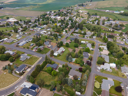
Colton WA aerial, May 2023.png
Aerial view of Colton in 2023
Whitman County Washington Incorporated and Unincorporated areas Colton Highlighted.svg
Location of Colton, Washington
Coordinates: 46°34′N117°8′W / 46.567°N 117.133°W / 46.567; -117.133
Country United States
State Washington
County Whitman
Area
[1]
  Total0.62 sq mi (1.60 km2)
  Land0.62 sq mi (1.60 km2)
  Water0.00 sq mi (0.00 km2)
Elevation
2,562 ft (781 m)
Population
 (2020)
  Total401
  Density650/sq mi (250/km2)
Time zone UTC-8 (Pacific (PST))
  Summer (DST) UTC-7 (PDT)
ZIP code
99113
Area code 509
FIPS code 53-13890
GNIS feature ID1504078 [2]

Colton is a town in Whitman County, Washington, United States. The population was 401 at the 2020 census. [3]

Contents

History

Colton was first settled in 1879 by J.A. Cole, [4] and was founded[ clarification needed ] in 1882 by J.B. Stanley. [5] Colton was incorporated in 1890 however it was not recorded until 1893.

Plans for the formation of Colton were made in 1879. Several residents of the town of Uniontown, which was settled a few years earlier, found dissatisfaction with the proprietor of that town. In June 1879, the town of Colton was surveyed and platted on the 480 acre farm of Gregor Kosher. That month L.J, Wolford moved his hotel to Colton and Chris Adamson moved his blacksmith shop. Dr. Cole erected the first new building on the corner of Steptoe and Broadway (now Main Street); J.B. Standley moved his small supply of merchandise into the new building. The town took its name from the first three letters of Cole, and the last three from Clinton, a son of Mr. Wolford, whose family was the first to live in Colton.

On October 10, 1879, John Standley was appointed postmaster and opened a post office in his own store. During the summer of 1880 a petition was granted from the county seat, at Asotin to separate Colton from the school district of Uniontown. The first school was opened in the Cole Building. Mrs. Viola Flowers was the first teacher.

Colton was a filming location for country artist Kenny Chesney in his 1995 hit song Me and You .

Notable natives

Geography

Colton is located along U.S. Route 195 in the Palouse region of southeastern Washington, just west of the Idaho border. [6]

According to the United States Census Bureau, the town has a total area of 0.59 square miles (1.53 km2), all of it land. [7]

Distances

Climate

This region experiences warm (but not hot) and dry summers, with no average monthly temperatures above 71.6 °F. According to the Köppen Climate Classification system, Colton has a warm-summer Mediterranean climate, abbreviated "Csb" on climate maps. [8]

Demographics

Historical population
CensusPop.Note
1900 251
1910 39356.6%
1920 382−2.8%
1930 269−29.6%
1940 262−2.6%
1950 207−21.0%
1960 25322.2%
1970 27910.3%
1980 30710.0%
1990 3255.9%
2000 38618.8%
2010 4188.3%
2020 401−4.1%
Source: [9]
U.S. Decennial Census [10]

2010 census

As of the 2010 census, [11] there were 418 people, 164 households, and 126 families living in the town. The population density was 708.5 inhabitants per square mile (273.6/km2). There were 167 housing units at an average density of 283.1 units per square mile (109.3 units/km2). The racial makeup of the town was 95.5% White, 0.2% Native American, 0.7% Asian, 0.5% from other races, and 3.1% from two or more races. Hispanic or Latino of any race were 3.1% of the population.

There were 164 households, of which 33.5% had children under the age of 18 living with them, 68.9% were married couples living together, 6.7% had a female householder with no husband present, 1.2% had a male householder with no wife present, and 23.2% were non-families. 18.9% of all households were made up of individuals, and 6.1% had someone living alone who was 65 years of age or older. The average household size was 2.55 and the average family size was 2.91.

The median age in the town was 44.2 years. 26.1% of residents were under the age of 18; 5.3% were between the ages of 18 and 24; 19.9% were from 25 to 44; 33.3% were from 45 to 64; and 15.6% were 65 years of age or older. The gender makeup of the town was 51.0% male and 49.0% female.

2000 census

As of the 2000 census, there were 386 people, 148 households, and 108 families living in the town. The population density was 655.0 people per square mile (252.9 people/km2). There were 152 housing units at an average density of 257.9 units per square mile (99.6 units/km2). The racial makeup of the town was 97.41% White, 1.04% Native American, 0.78% Asian, and 0.78% from two or more races. Hispanic or Latino of any race were 0.78% of the population.

There were 148 households, out of which 35.1% had children under the age of 18 living with them, 65.5% were married couples living together, 5.4% had a female householder with no husband present, and 26.4% were non-families. 24.3% of all households were made up of individuals, and 10.8% had someone living alone who was 65 years of age or older. The average household size was 2.61 and the average family size was 3.14.

In the town, the age distribution of the population shows 29.0% under the age of 18, 3.6% from 18 to 24, 28.2% from 25 to 44, 25.4% from 45 to 64, and 13.7% who were 65 years of age or older. The median age was 38 years. For every 100 females, there were 96.9 males. For every 100 females age 18 and over, there were 94.3 males.

The median income for a household in the town was $47,500, and the median income for a family was $56,875. Males had a median income of $38,125 versus $28,611 for females. The per capita income for the town was $21,506. About 3.5% of families and 2.7% of the population were below the poverty line, including 5.0% of those under age 18 and none of those age 65 or over.
Related Research Articles

<span class="mw-page-title-main">Washington County, Idaho</span> County in Idaho, United States

Washington County is a county in the U.S. state of Idaho. As of the 2020 census, the population was 10,500. The county seat and largest city is Weiser, with over half of the county's population. The county was established in 1879 when Idaho was a territory and named after U.S. President George Washington.

<span class="mw-page-title-main">Clearwater County, Idaho</span> County in Idaho, United States

Clearwater County is a county located in the U.S. state of Idaho. As of the 2020 census, the population was 8,734. The county seat is Orofino. Established in 1911, the county was named after the Clearwater River.

<span class="mw-page-title-main">Butte County, Idaho</span> County in Idaho, United States

Butte County is a rural county located in the U.S. state of Idaho. As of the 2020 census, the population was 2,574, making it the third-least populous county in Idaho. Its county seat and largest city is Arco. The county was established in 1917 from parts of Bingham, Blaine, and Jefferson counties. The county gained territory in the Clyde area from Custer County in 1937 to reach its present boundary.

<span class="mw-page-title-main">Eagle, Idaho</span> City in Idaho, United States

Eagle is a city in Ada County, Idaho, ten miles (16 km) northwest of downtown Boise. The population was 30,346 at the 2020 census.

<span class="mw-page-title-main">Oldtown, Idaho</span> City in Idaho, United States

Oldtown is a city in Bonner County, Idaho and suburb of Newport, Washington, with a population of 184 at the 2010 census. It is located on the Pend Oreille River, just east of Newport. There are no natural or physical barriers, and it is strictly a political division, separated by the straight-line state boundary. Oldtown is squeezed between this boundary to the west and the river to the east, leaving the main business district on U.S. Route 2 with only 700 feet of space in which to operate on the Idaho side. Many homes are located in the south end on the other side of the railroad, as the Pend Oreille is somewhat further away here.

<span class="mw-page-title-main">Priest River, Idaho</span> City in Idaho, United States

Priest River is a city in Bonner County, Idaho. The population was 1,696 at the 2020 census, and 1,751 at the 2010 census. Located in the Idaho Panhandle region of the state, the city is at the mouth of the Priest River on the Pend Oreille River.

<span class="mw-page-title-main">Middleton, Idaho</span> City in Idaho, United States

Middleton is a city in Canyon County, Idaho, United States. The population amounted to 9,091 at the 2021 census estimate, up from 5,524 at the 2010 census and 2,978 in 2000. It is part of the Boise City–Nampa, Idaho Metropolitan Statistical Area.

<span class="mw-page-title-main">Franklin, Idaho</span> City in Idaho, United States

Franklin is a city in Franklin County, Idaho, United States. The population was 1,025 at the 2020 census. It is part of the Logan, Utah-Idaho Metropolitan Statistical Area.

<span class="mw-page-title-main">Stites, Idaho</span> City in Idaho, United States

Stites is a city in Idaho County, Idaho, United States. In the lower canyon of the South Fork of the Clearwater River, it is about four miles (6 km) upstream and south of Kooskia on State Highway 13. The population was 221 at the 2010 census, down from 226 in 2000.

<span class="mw-page-title-main">Jerome, Idaho</span> City in Idaho, United States

Jerome is a city in and county seat of Jerome County, Idaho, United States. The population was 10,890 at the 2010 census, up from 7,780 in 2000. The city is the county seat of Jerome County, and is part of the Twin Falls Micropolitan Statistical Area. It is the second largest city in Idaho's Magic Valley region, second only to Twin Falls which is located 10 miles (16 km) southeast. Jerome's economy is largely agrarian, with dairy farming being one of the main revenue sources for the local economy.

<span class="mw-page-title-main">Spirit Lake, Idaho</span> City in Idaho, United States

Spirit Lake is a city in Kootenai County, Idaho. The population was 1,945 at the time of the 2010 census, up from 1,376 in 2000. It is part of the Coeur d'Alene Metropolitan Statistical Area, which includes the entire county.

<span class="mw-page-title-main">Genesee, Idaho</span> City in Idaho, United States

Genesee is a city in Latah County, Idaho, United States. The population was 955 at the 2010 census, up from 946 in 2000. The city was named for the Genesee region of western New York, although it may also be a modification of the biblical Genesis.

<span class="mw-page-title-main">Troy, Idaho</span> City in Idaho, United States

Troy is a city in Latah County, Idaho, United States. Located in the eastern part of the Palouse region, its population was 862 at the 2010 census.

<span class="mw-page-title-main">Leadore, Idaho</span> City in Idaho, United States

Leadore is an incorporated small town in Lemhi County, Idaho, United States. The population was 105 at the 2010 census.

<span class="mw-page-title-main">Sugar City, Idaho</span> City in Idaho, United States

Sugar City is a city in Madison County, Idaho, United States. The population was 1,715 at the 2020 census, up from 1,514 in 2010. It is part of the Rexburg Micropolitan Statistical Area.

<span class="mw-page-title-main">Paul, Idaho</span> City in Idaho, United States

Paul is a city in Minidoka County, Idaho, United States. founded in 1907. The population was 1,195 at the 2020 census. It is part of the Burley, Idaho Micropolitan Statistical Area. The town received its name from Charles H. Paul, an engineer who worked on the Minidoka Project.

<span class="mw-page-title-main">Cole, Oklahoma</span> Town in Oklahoma, United States

Cole is a town in McClain County, Oklahoma, United States. The population was 624 at the 2020 census, up from 555 at the 2010 census.

<span class="mw-page-title-main">Colton, South Dakota</span> City in South Dakota, United States

Colton is a city in Minnehaha County, South Dakota, United States. The population was 738 at the 2020 census.

<span class="mw-page-title-main">Garfield, Washington</span> Town in Washington, United States

Garfield is a city in Whitman County, Washington, United States. The population was 562 at the 2020 census.

<span class="mw-page-title-main">Uniontown, Washington</span> Town in Washington, United States

Uniontown is a town in Whitman County, Washington, United States. The population was 389 at the 2020 census.

References

  1. "2019 U.S. Gazetteer Files". United States Census Bureau. Retrieved August 7, 2020.
  2. "US Board on Geographic Names". United States Geological Survey. October 25, 2007. Retrieved January 31, 2008.
  3. "Census Bureau profile: Colton, Washington". United States Census Bureau. May 2023. Retrieved May 11, 2024.
  4. Hyde, Susan M. (June 3, 1989). "A town built on celebration". Idahonian. (Moscow). p. 1B.
  5. Majors, Harry M. (1975). Exploring Washington. Van Winkle Publishing Co. p. 143. ISBN   978-0-918664-00-6.
  6. Collingwood, Ryan (August 27, 2020). "Colton's merger with Genesee, Idaho, lets six Washington students play football this fall". The Spokesman-Review . Retrieved February 29, 2024.
  7. "US Gazetteer files 2010". United States Census Bureau. Archived from the original on July 2, 2012. Retrieved December 19, 2012.
  8. Climate Summary for Colton, Washington
  9. Moffatt, Riley. Population History of Western U.S. Cities & Towns, 1850-1990. Lanham: Scarecrow, 1996, 335.
  10. United States Census Bureau. "Census of Population and Housing" . Retrieved October 11, 2013.
  11. "U.S. Census website". United States Census Bureau . Retrieved December 19, 2012.