The Advisory Committee on Antarctic Names is an advisory committee of the United States Board on Geographic Names responsible for recommending commemorative names for features in Antarctica.

The Lakes of the Clouds are a set of tarns located at the 5,032 ft (1,534 m) col between Mount Monroe and Mount Washington in the White Mountains of the U.S. state of New Hampshire. The lakes form the source of the Ammonoosuc River, a tributary of the Connecticut River. They are recorded by the Geographic Names Information System as the highest elevation lakes in the United States east of South Dakota.

The Little Pend Oreille National Wildlife Refuge is a wildlife preserve, one of the national wildlife refuges operated by the United States Fish and Wildlife Service. The refuge is located east of Colville, Washington, along the west slope of the Selkirk Mountain Range. It lies mostly in eastern Stevens County, with a small part extending eastward into western Pend Oreille County. It is the only mountainous, mixed-conifer forest refuge outside Alaska and the largest in Washington state.

Grotto is a small unincorporated community in King County, Washington, United States. It is located on U.S. Route 2 west of Stevens Pass in the Cascade Mountains, near the town of Skykomish. Grotto is known for its scenic mountain environment.

Piscataway Creek is an 18.6-mile-long (29.9 km) tributary of the Potomac River in Prince George's County, Maryland. The creek is a tidal arm of the Potomac for its final 2.5 miles (4.0 km), entering the Potomac at Fort Washington Park. Tinkers Creek is a tributary to Piscataway Creek, converging from the north 4.5 miles (7.2 km) upstream of the mouth of the Piscataway. The United States Geological Survey records two variant names for Piscataway Creek: Pascattawaye Creek and Puscattuway Creeke.

The Columbia Hills are an area of hills and small mountains along the north bank of the Columbia River in Klickitat County, in south-central Washington state, US. They have a maximum elevation of 2,667 feet (813 m).
Megler is a small unincorporated community in Pacific County in the U.S. state of Washington. Named for legislator Joseph G. Megler, the community is at the mouth of the Columbia River on the north shore of the river. It is the northern end of the Astoria-Megler Bridge, which connects Megler to Astoria, Oregon, a nearby city on the south shore of the river. U.S. Route 101 and State Route 401 intersect in the community and connect Megler to Aberdeen, Olympia, and Vancouver.

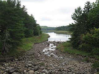
Sprague Lake is a scenic lake in Rocky Mountain National Park, located on the south side of Glacier Creek, about two miles south of the Hollowell turnoff. The half-mile walk around the lake is wheelchair accessible and features boardwalks and bridges with views of Flattop Mountain and Hallet Peak. The lake is popular for Brook trout fishing.
Hardscrabble River is the estuary of Wilson Stream, a small river in Washington County, Maine. From its source in Charlotte, Wilson Stream runs about 10 miles (16 km) southeast to Dennys Bay. It changes name to Hardscrabble River at about the point where it is crossed by U.S. Route 1. This section of the stream separates Pembroke on its left bank from Dennysville and Edmunds on its right.
The Harrington River is a 7.3-mile-long (11.7 km) river in Washington County, Maine. It empties into Harrington Bay in Harrington, Maine.

Posadowsky Glacier is a glacier about 9 nautical miles long, flowing north to Posadowsky Bay immediately east of Gaussberg. Posadowsky Bay is an open embayment, located just east of the West Ice Shelf and fronting on the Davis Sea in Kaiser Wilhelm II Land. Kaiser Wilhelm II Land is the part of East Antarctica lying between Cape Penck, at 87°43'E, and Cape Filchner, at 91°54'E, and is claimed by Australia as part of the Australian Antarctic Territory. Other notable geographic features in this area include Drygalski Island, located 45 mi NNE of Cape Filchner in the Davis Sea, and Mirny Station, a Russian scientific research station.
Byron is an unincorporated community in Yakima County, Washington, United States, located approximately three miles west of Prosser.
East Selah is an unincorporated community in Yakima County, Washington, United States, located east of Selah adjacent to the Yakima River.
Washington Peak at 10,519 feet (3,206 m) above sea level is a peak in the White Cloud Mountains of Idaho. The peak is located in Sawtooth National Recreation Area in Custer County 2.37 mi (3.81 km) from Fourth of July Peak, its line parent. It is the 264th highest peak in Idaho.

Venetia is an unincorporated community in Peters Township, Washington County, Pennsylvania, United States. It has a post office with the ZIP code 15367, covering most of the area between McMurray and Gastonville. The population of this area was 8,731 at the 2010 census. It is part of the Pittsburgh metropolitan area.

Hazard is an unincorporated community in Spokane County, in the U.S. state of Washington.

Cincinnati is an unincorporated community in Washington Township, Parke County, in the U.S. state of Indiana.
Pin Hook is an unincorporated community in Washington Township, Parke County, in the U.S. state of Indiana.
Washington Center is an unincorporated community in Washington Township, Noble County, in the U.S. state of Indiana.


