Elberton, Washington

Last updated

Elberton
United Brethren Church in Elberton, Washington.jpg
Abandoned United Brethren Church building in Elberton
USA Washington location map.svg
Red pog.svg
Elberton
Location in Washington
Coordinates: 46°58′53″N117°13′13″W / 46.98139°N 117.22028°W / 46.98139; -117.22028
Country United States
State Washington
County Whitman
IncorporatedApril 24, 1896
DisincorporatedJanuary 14, 1966
Population
  Estimate 
(as of unknown date)
15
Time zone UTC-8 (PST)
  Summer (DST) UTC-7 (PDT)

Elberton is an uincorporated community on the north fork of the Palouse River northeast of Colfax and northwest of Palouse in Whitman County, Washington, United States. Due to the town's disincorporation in the 1960s, and a low-level population, it is also classified as a ghost town.

Contents

Geography

The nearest cities to Elberton are Spokane and Pullman in Washington, Moscow in Idaho, and the Lewiston/Clarkston metropolitan area that spans the two states. It is in the middle of the Columbia River Plateau, in a region called the Palouse.

History

Elberton was first settled by C.D. Wilbur. The townsite was platted in 1886, and named by S.M. Wait for his deceased son Elbert. [1]

Elberton was incorporated as a fourth class town on 24 April 1896. It grew to have a population of 500 and at one time had a sawmill, a flour mill, a railroad (the Oregon-Washington Railroad and Navigation Company) that passed through and the world's largest prune dryer. [2]

A major fire started in the town in the 1930s and due to the Great Depression, many of the businesses and homes destroyed by the fire were too costly to rebuild. The fire, along with the Depression hurt the town greatly and it started to decline in population, with people packing up what they could carry and abandoning their homes that they could no longer afford to keep and maintain.

In November 1966, residents of Elberton voted 15–5 in favor of dis-incorporation. [3] Elberton became part of unincorporated Whitman County, Washington again within four years, when the county acquired the property of the town. As of 2005, Eleberton is the last instance of a municipality in Washington voting to disincorporate. [4]

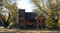
Currently, about 15 people live in the 200-acre (0.81 km2) area that once was Elberton. [4] Many of the original homes and buildings have gone or are partially collapsed. Remaining landmarks include United Brethren Church (built in 1913) and the Elberton Cemetery. [5]

See also

Related Research Articles

<span class="mw-page-title-main">Whitman County, Washington</span> County in Washington, United States

Whitman County is a county located in the U.S. state of Washington. As of the 2020 census, the population was 47,973. The county seat is Colfax, and its largest city is Pullman.

<span class="mw-page-title-main">Latah County, Idaho</span> County in Idaho, United States

Latah County is a county located in the north central region of the U.S. state of Idaho. As of the 2020 census, the population was 39,517. The county seat and largest city is Moscow, the home of the University of Idaho, the state's flagship university.

<span class="mw-page-title-main">Ritzville, Washington</span> City in Washington, United States

Ritzville is a city in Adams County, Washington, United States. The population was 1,767 at the 2020 census. It is the county seat of Adams County. The city is part of the Othello, WA Micropolitan Area, which comprises all of Adams County, and is part of the larger Moses Lake-Othello, WA Combined Statistical Area.

<span class="mw-page-title-main">Spokane, Washington</span> City in Washington, United States

Spokane is the largest city in and seat of government of Spokane County, Washington, United States. It is in eastern Washington, along the Spokane River, adjacent to the Selkirk Mountains, and west of the Rocky Mountain foothills, 92 miles (148 km) south of the Canadian border, 18 miles (30 km) west of the Washington–Idaho border, and 279 miles (449 km) east of Seattle, along I-90.

<span class="mw-page-title-main">Colfax, Washington</span> City in Washington, United States

Colfax is the county seat of Whitman County, Washington, United States. The population was 2,805 at the 2010 census. The population is estimated at 2,911 per the State of Washington Office of Financial Management in 2018 making Colfax the second largest city in Whitman County behind Pullman. It is situated amidst wheat-covered hills in a valley at the confluence of the north and south forks of the Palouse River. U.S. Route 195, which forms the town's main street, intersects with State Route 26 at the north end of town; in the past, Colfax also lay at the junction of three major railway lines. It was named after Schuyler Colfax, the vice president from 1869–73.

<span class="mw-page-title-main">Palouse, Washington</span> City in Washington, United States

Palouse is a city in Whitman County, Washington, United States. The population was 998 at the 2010 census.

<span class="mw-page-title-main">Pullman, Washington</span> City in Washington, United States

Pullman is the largest city in Whitman County, located in southeastern Washington within the Palouse region of the Pacific Northwest. The population was 29,799 at the 2010 census, and estimated to be 34,506 in 2019. Originally founded as Three Forks, the city was renamed after industrialist George Pullman in 1884.

<span class="mw-page-title-main">Tekoa, Washington</span> City in Washington, United States

Tekoa is a small farming town in Whitman County, Washington, United States. The population was 778 at the 2010 census.

<span class="mw-page-title-main">Spokane Valley, Washington</span> City in Washington, United States

Spokane Valley is a city in Spokane County, Washington, United States, and the largest suburb of Spokane. It is located east of Spokane, west of Coeur d'Alene, Idaho, and surrounds the city of Millwood on three sides. The city incorporated as the City of Spokane Valley on March 31, 2003. The population was 102,976 at the 2020 census, making it the eighth-largest city in Washington state. Spokane Valley is named after the valley of the Spokane River, in which it is located. The city and the general area is colloquially referred to as "The Valley" by residents of the Spokane–Coeur d'Alene area.

<span class="mw-page-title-main">Eastern Washington</span> Geographic region in Washington, United States

Eastern Washington is the region of the U.S. state of Washington located east of the Cascade Range. It contains the city of Spokane, the Tri-Cities, the Columbia River and the Grand Coulee Dam, the Hanford Nuclear Reservation and the fertile farmlands of the Yakima Valley and the Palouse. Unlike in Western Washington, the climate is dry, including some desert environments.

<span class="mw-page-title-main">Palouse</span> Geographic region of Northwestern United States dominated by wheat-based agriculture

The Palouse is a distinct geographic region of the northwestern United States, encompassing parts of north central Idaho, southeastern Washington, and, by some definitions, parts of northeast Oregon. It is a major agricultural area, primarily producing wheat and legumes. Situated about 160 miles (260 km) north of the Oregon Trail, the region experienced rapid growth in the late 19th century.

<span class="mw-page-title-main">Washington State Route 27</span> Highway in Washington, United States

State Route 27 (SR 27) is a 90-mile-long (145 km) state highway serving Whitman and Spokane counties, located in the eastern region of the U.S. state of Washington. The highway travels generally north from U.S. Route 195 (US 195) through Pullman, Palouse, Tekoa, and Spokane Valley to SR 290 north of an interchange with Interstate 90 (I-90). SR 27 serves the Palouse region as part of the Palouse Scenic Byway and travels between US 195 to the west and US 95 to the east in Idaho, with several auxiliary routes connecting to the two other highways.

<span class="mw-page-title-main">History of Spokane, Washington</span>

The history of Spokane, Washington in the northwestern United States developed because Spokane Falls and its surroundings were a gathering place for numerous cultures for thousands of years. The area's indigenous people settled there due to the fertile hunting grounds and abundance of salmon in the Spokane River. The first European to explore the Inland Northwest was Canadian explorer-geographer David Thompson, working as head of the North West Company's Columbia Department. At the nexus of the Little Spokane and the Spokane, Thompson's men built a new fur trading post, which is the first long-term European settlement in Washington state.

<span class="mw-page-title-main">William Goodyear</span>

William Goodyear was an American football coach, newspaper editor, publisher, and politician in Whitman County in eastern Washington. He was the first head coach of the Washington State Cougars football team, holding that position for the 1894 college football season. Goodyear was also a newspaper publisher and editor. His newspapers included the Pullman Herald, the Pullman News, the Colfax Commoner in Colfax, Washington, the Palouse City News in Palouse, Washington, and the Pacific Farmers' Union. He was also active in Democratic Party politics and was the party's candidate for United States Congress in Washington's 3rd congressional district in 1908.

The Washington and Idaho Railway was a shortline railroad that operated in the area south of Spokane, Washington, connecting the BNSF Railway at Marshall to Palouse, Washington, Harvard, Idaho, and Moscow, Idaho. It began operations in 2006 on ex-Northern Pacific Railway and Washington, Idaho and Montana Railway trackage formerly operated by the Palouse River and Coulee City Railroad, which had acquired it from the Burlington Northern Railroad in 1996. The railroad ceased operations in 2019 as a new operator gained control of the line.

The Bill Chipman Palouse Trail is a paved rail trail in the northwestern United States, from Pullman, Washington, eastward to Moscow, Idaho. Completed 25 years ago in 1998, it follows the former Union Pacific Railroad right-of-way and connects the rural university towns on the Palouse across the state border.

<span class="mw-page-title-main">Valleyford, Washington</span> Unincorporated community in Washington, United States

Valleyford is an unincorporated community in Spokane County, Washington, United States. Valleyford has a post office with ZIP code 99036. Valleyford was listed to have a population of 2,913 according to the 2010 United States census.

<span class="mw-page-title-main">Star Route and Palouse Street Brick Road</span> Neighborhood of Pullman, Washington, U.S.

The Star Route and Palouse Street Brick Road, in Pullman, Washington, also known as the nickname Red Brick Roads are a block of NE Maple St. and a block of NE Palouse St. and together are the last remaining brick streets in the city. In 2014, the roads were listed on the National Register of Historic Places. The roads, paved in 1913, are important landmarks because they made transportation easier along the only of the city's Star routes, providing an essential connection between the Northern Pacific Railroad depot and the growing campus of Washington State College. The steepest part of the route to campus received brick paving to provide traction for horses and automobiles—particularly during the difficult winter months.

East Redmond was a short-lived town in King County, Washington that existed from 1956 to 1965. The town, then located to the east of Redmond in the Seattle metropolitan area, was formed as a result of a land use dispute between neighbors. East Redmond, with a population of fewer than 400 people, was found to have not met the state's minimum population requirement for incorporation and was dis-incorporated by a decision of the Washington Supreme Court in 1965.

<span class="mw-page-title-main">2020 Washington Labor Day fires</span>

The 2020 Washington Labor Day fires were part of the 2020 wildfires in the U.S. state of Washington. The Labor Day fires began on September 7, 2020, driven by high winds and some of which were sparked by downed power lines. More than 330,000 acres (130,000 ha) burned across the state of Washington, a one-day total greater than any of the last 12 entire fire seasons, according to the governor's office, and larger than the state's largest single fire, the Carlton Complex Fire of 2014.

References

  1. Majors, Harry M. (1975). Exploring Washington. Van Winkle Publishing Co. p. 143. ISBN   978-0-918664-00-6.
  2. Benoit, Matt (October 2, 2013). "Haunting a Ghost Town". Inlander . Retrieved September 16, 2018.
  3. "Prune Town Dries Up". St. Petersburg Independent . November 19, 1966. p. 14-A.
  4. 1 2 Cooley, Megan (March 5, 2005). "City's demise could mean state control". The Spokesman Review. Retrieved September 11, 2022.
  5. Lambeth, Robert M. "Ghost Town of Elberton". Spokane Historical. Retrieved September 11, 2022.