La Crosse, Washington

Last updated

LaCrosse
Lacrosse Washington IMG 1285.JPG
Photo of LaCrosse taken from the south
Whitman County Washington Incorporated and Unincorporated areas La Crosse Highlighted.svg
Location of LaCrosse, Washington
Coordinates: 46°48′51″N117°52′48″W / 46.81417°N 117.88000°W / 46.81417; -117.88000
CountryUnited States
State Washington
County Whitman
Incorporated February 19, 1917
Government
   Mayor Randy Camp
Area
[1]
  Total0.85 sq mi (2.21 km2)
  Land0.85 sq mi (2.21 km2)
  Water0.00 sq mi (0.00 km2)
Elevation
[2]
1,480 ft (451 m)
Population
 (2020) [3]
  Total297
  Estimate 
(2022) [4]
294
  Density373.54/sq mi (144.14/km2)
Time zone UTC–8 (Pacific (PST))
  Summer (DST) UTC–7 (PDT)
ZIP codes
99136, 99143
Area code 509
FIPS code 53-36850
GNIS feature ID1506035 [2]
Sales tax 7.9% [5]
Website lacrossewa.us

LaCrosse is a rural small town in Whitman County, Washington, United States. The population was 297 at the 2020 census. [3]

Contents

History

With the completion in 1888 of the Oregon Railroad and Navigation Company (O.R. & N) railroad line between Riparia and LaCrosse, George Dawson and his wife built a shack constructed from railroad ties. By 1889, LaCrosse had a population of 12. The first real store was constructed in 1899 by Tom Shobe.

LaCrosse was incorporated on February 19, 1917.

Geography

LaCrosse is located at 46°48′51″N117°52′48″W / 46.81417°N 117.88000°W / 46.81417; -117.88000 (46.814289, -117.880097). [6]

According to the United States Census Bureau, the town has a total area of 0.78 square miles (2.02 km2), all of it land. [7]

Climate

According to the Köppen Climate Classification system, LaCrosse has a warm-summer Mediterranean climate, abbreviated "Csb" on climate maps.

Climate data for La Crosse, Washington (1991–2020 normals, extremes 1901–2021)
MonthJanFebMarAprMayJunJulAugSepOctNovDecYear
Record high °F (°C)64
(18)
70
(21)
80
(27)
95
(35)
100
(38)
113
(45)
110
(43)
113
(45)
104
(40)
92
(33)
76
(24)
66
(19)
113
(45)
Mean daily maximum °F (°C)38.8
(3.8)
44.8
(7.1)
53.7
(12.1)
61.9
(16.6)
71.5
(21.9)
79.4
(26.3)
90.0
(32.2)
88.8
(31.6)
78.5
(25.8)
62.7
(17.1)
47.3
(8.5)
37.9
(3.3)
62.9
(17.2)
Daily mean °F (°C)32.3
(0.2)
35.8
(2.1)
42.3
(5.7)
48.7
(9.3)
56.7
(13.7)
63.6
(17.6)
71.3
(21.8)
70.3
(21.3)
61.2
(16.2)
49.3
(9.6)
38.6
(3.7)
31.2
(−0.4)
50.1
(10.1)
Mean daily minimum °F (°C)25.8
(−3.4)
26.9
(−2.8)
30.8
(−0.7)
35.5
(1.9)
41.9
(5.5)
47.7
(8.7)
52.5
(11.4)
51.8
(11.0)
44.0
(6.7)
35.8
(2.1)
29.8
(−1.2)
24.5
(−4.2)
37.3
(2.9)
Record low °F (°C)−30
(−34)
−24
(−31)
−6
(−21)
8
(−13)
19
(−7)
26
(−3)
30
(−1)
28
(−2)
15
(−9)
3
(−16)
−17
(−27)
−34
(−37)
−34
(−37)
Average precipitation inches (mm)1.96
(50)
1.34
(34)
1.66
(42)
1.30
(33)
1.26
(32)
0.96
(24)
0.31
(7.9)
0.32
(8.1)
0.50
(13)
1.12
(28)
1.96
(50)
2.37
(60)
15.06
(383)
Average snowfall inches (cm)4.1
(10)
2.2
(5.6)
0.8
(2.0)
0.1
(0.25)
0.0
(0.0)
0.0
(0.0)
0.0
(0.0)
0.0
(0.0)
0.0
(0.0)
0.0
(0.0)
1.8
(4.6)
8.1
(21)
17.1
(43)
Average precipitation days (≥ 0.01 in)14.011.411.99.17.96.32.92.73.68.313.214.6105.9
Average snowy days (≥ 0.1 in)4.41.71.10.20.00.00.00.00.00.11.25.314.0
Source: NOAA [8] [9]

Demographics

Historical population
CensusPop.Note
1930 471
1940 4750.8%
1950 457−3.8%
1960 4631.3%
1970 426−8.0%
1980 373−12.4%
1990 336−9.9%
2000 38013.1%
2010 313−17.6%
2020 297−5.1%
2022 (est.)294 [4] −1.0%
U.S. Decennial Census [10]
2020 Census [3]

2010 census

As of the 2010 census, there were 313 people, 153 households, and 96 families residing in the town. The population density was 401.3 inhabitants per square mile (154.9/km2). There were 181 housing units at an average density of 232.1 per square mile (89.6/km2). The racial makeup of the town was 95.8% White, 0.3% African American, 0.6% Native American, 0.3% Asian, 0.3% from other races, and 2.6% from two or more races. Hispanic or Latino of any race were 0.3% of the population.

There were 153 households, of which 19.6% had children under the age of 18 living with them, 52.9% were married couples living together, 5.2% had a female householder with no husband present, 4.6% had a male householder with no wife present, and 37.3% were non-families. 33.3% of all households were made up of individuals, and 22.9% had someone living alone who was 65 years of age or older. The average household size was 2.05 and the average family size was 2.53.

The median age in the town was 51.8 years. 15.7% of residents were under the age of 18; 5.4% were between the ages of 18 and 24; 14.8% were from 25 to 44; 34.2% were from 45 to 64; and 30% were 65 years of age or older. The gender makeup of the town was 50.2% male and 49.8% female.

2000 census

As of the 2000 census, there were 380 people, 164 households, and 105 families residing in the town. The population density was 1,101.6 people per square mile (431.5/km2). There were 187 housing units at an average density of 542.1 per square mile (212.4/km2). The racial makeup of the town was 93.42% White, 3.16% Native American, 0.26% Asian, 0.53% from other races, and 2.63% from two or more races. Hispanic or Latino of any race were 0.53% of the population.

There were 164 households, out of which 31.1% had children under the age of 18 living with them, 54.3% were married couples living together, 9.1% had a female householder with no husband present, and 35.4% were non-families. 32.9% of all households were made up of individuals, and 19.5% had someone living alone who was 65 years of age or older. The average household size was 2.32 and the average family size was 2.90.

In the town, the age distribution of the population shows 28.2% under the age of 18, 1.6% from 18 to 24, 26.6% from 25 to 44, 21.1% from 45 to 64, and 22.6% who were 65 years of age or older. The median age was 42 years. For every 100 females, there were 99.0 males. For every 100 females age 18 and over, there were 88.3 males.

The median income for a household in the town was $30,893, and the median income for a family was $40,833. Males had a median income of $30,972 versus $20,313 for females. The per capita income for the town was $16,656. About 2.1% of families and 5.9% of the population were below the poverty line, including 4.5% of those under age 18 and 6.0% of those age 65 or over.

Notable groups and events

The La Crosse Arts and Beautification Council was created in 2005 with aspirations of renovating downtown LaCrosse while promoting the arts, local culture, and history of LaCrosse and the Palouse. Events have included the Valentine Fine Arts Night and the Spring Faire.

The La Crosse Gun Club holds an annual "Bacon & Crab Shooting" event at the end of January.

The La Crosse Farmers Festival, held in mid-June, is celebrated with a parade and live entertainment. This has not been held for several years, and it is not known why.

Related Research Articles

<span class="mw-page-title-main">LaCrosse, Florida</span> Town in the state of Florida, United States

LaCrosse is a town in Alachua County, Florida, 15 miles (24 km) north of Gainesville. The LaCrosse is part of the Gainesville, Florida Metropolitan Statistical Area. As of the 2020 US census, the town population was 316, down from 360 in 2010 US Census.

<span class="mw-page-title-main">La Crosse, Indiana</span> Town in Indiana, United States

La Crosse is a town in LaPorte County, Indiana, United States. The population was 551 at the 2010 census. It is included in the Michigan City, Indiana-La Porte, Indiana Metropolitan Statistical Area.

<span class="mw-page-title-main">La Crosse, Kansas</span> City in Rush County, Kansas

La Crosse is a city in and the county seat of Rush County, Kansas, United States. As of the 2020 census, the population of the city was 1,266. La Crosse proclaims itself the "Barbed Wire capital of the world.

<span class="mw-page-title-main">Caledonia, Minnesota</span> City in Minnesota, United States

Caledonia is a city and the county seat of Houston County, Minnesota, United States and is part of the La Crosse, Wisconsin Metropolitan Statistical Area. The population was 2,847 at the 2020 census.

<span class="mw-page-title-main">Dakota, Minnesota</span> City in Minnesota, United States

Dakota is a city in Winona County, Minnesota, United States. The population was 295 at the 2020 census.

<span class="mw-page-title-main">Northfield, Wisconsin</span> Town in Wisconsin, United States

Northfield is a town in Jackson County, Wisconsin, United States. The population was 586 at the 2000 census. The unincorporated communities of Northfield and York are located in the town.

<span class="mw-page-title-main">Burns, Wisconsin</span> Town in Wisconsin, United States

Burns is a town in La Crosse County, Wisconsin, United States. The population was 949 at the 2010 census. It is part of the La Crosse, Wisconsin Metropolitan Statistical Area. The unincorporated communities of Burns and Burns Corners are located in the town.

<span class="mw-page-title-main">Campbell, Wisconsin</span> Town in Wisconsin, United States

Campbell is a town in the middle of the Mississippi River in La Crosse County, Wisconsin, United States. It is part of the La Crosse, Wisconsin Metropolitan Statistical Area. The population was 4,284 as of the 2020 Census.

<span class="mw-page-title-main">Farmington, La Crosse County, Wisconsin</span> Town in Wisconsin, United States

Farmington is a town in La Crosse County, Wisconsin, United States. The population was 2,061 at the 2010 census, up from 1,733 at the 2000 census. It is part of the La Crosse Metropolitan Statistical Area. The unincorporated communities of Burr Oak, Mindoro, and Stevenstown are in the town.

<span class="mw-page-title-main">Greenfield, La Crosse County, Wisconsin</span> Town in Wisconsin, United States

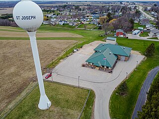
Greenfield is a town in La Crosse County, Wisconsin, United States. It is part of the La Crosse Metropolitan Statistical Area. The population was 2,060 as of the 2010 census, up from 1,538 at the 2000 census. The census-designated place of St. Joseph is located in the town.

<span class="mw-page-title-main">Shelby, Wisconsin</span> Town in Wisconsin, United States

Shelby is a town in La Crosse County, Wisconsin, United States. It is part of the La Crosse, Wisconsin Metropolitan Statistical Area. The population was 4,715 at the 2010 census. The unincorporated community of Shelby is located in the town.

<span class="mw-page-title-main">Washington, La Crosse County, Wisconsin</span> Town in Wisconsin, United States

Washington is a town in La Crosse County, Wisconsin, United States. It is part of the La Crosse, Wisconsin Metropolitan Statistical Area. The population was 745 at the 2010 census. The unincorporated communities of Middle Ridge and Newberg Corners are located in the town.

<span class="mw-page-title-main">Westby, Wisconsin</span> City in Wisconsin, United States

Westby is a city in Vernon County, Wisconsin, United States. The population was 2,332 as of the 2020 census. The name "Westby" is a Norwegian name and literally translates to "Western city".

<span class="mw-page-title-main">Hixton, Wisconsin</span> Village in Wisconsin, United States

Hixton is a village in Jackson County, Wisconsin, United States, along the Trempealeau River. The population was 433 at the 2010 census. The village is located within the Town of Hixton.

Hixton is a town in Jackson County, Wisconsin, United States. The population was 611 at the 2000 census. The Village of Hixton is located within the town. The unincorporated community of Sechlerville is also located in the town.

<span class="mw-page-title-main">Bangor (town), Wisconsin</span>

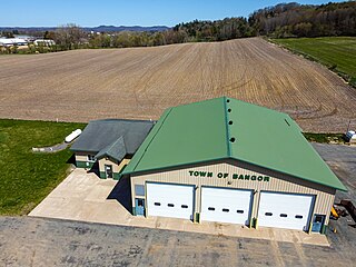
Bangor is a town in La Crosse County, Wisconsin, United States. It is part of the La Crosse, Wisconsin Metropolitan Statistical Area. The population was 570 at the 2010 census. The Village of Bangor is located partially within the town.

<span class="mw-page-title-main">Bangor, Wisconsin</span> Village in Wisconsin, United States

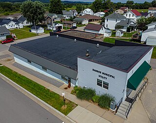
Bangor is a village in La Crosse County, Wisconsin, United States, along the La Crosse River. It is part of the La Crosse-Onalaska, WI-MN Metropolitan Statistical Area. The population was 1,437 as of the 2020 Census. The village is located partially within the Town of Bangor.

<span class="mw-page-title-main">Onalaska (town), Wisconsin</span> Town in the United States

Onalaska is a town in La Crosse County, Wisconsin, United States. The population was 5,623 at the 2010 census. The City of Onalaska borders the town, as does the village of Holmen. The CDP of Brice Prairie is located in the western part of the Town of Onalaska. The unincorporated community of Midway is also located in the town. Onalaska (town), Wisconsin is part of the La Crosse, Wisconsin Metropolitan Statistical Area.

<span class="mw-page-title-main">Onalaska, Wisconsin</span> City in the United States

Onalaska is a city in La Crosse County, Wisconsin, United States. The population was 18,803 at the 2020 census. It borders the larger La Crosse, Wisconsin, and is a part of the La Crosse-Onalaska, WI-MN Metropolitan Area.

<span class="mw-page-title-main">Genoa, Wisconsin</span> Village in Wisconsin, United States

Genoa is a village in Vernon County, Wisconsin, United States. The population was 232 at the 2020 census. The village is within the Town of Genoa.

References

  1. "2020 U.S. Gazetteer Files". United States Census Bureau. Retrieved July 24, 2022.
  2. 1 2 U.S. Geological Survey Geographic Names Information System: La Crosse, Washington
  3. 1 2 3 "Explore Census Data". United States Census Bureau . Retrieved January 8, 2024.
  4. 1 2 "City and Town Population Totals: 2020-2022". United States Census Bureau. January 8, 2024. Retrieved January 8, 2024.
  5. "LaCrosse (WA) sales tax rate" . Retrieved January 8, 2024.
  6. "US Gazetteer files: 2010, 2000, and 1990". United States Census Bureau. February 12, 2011. Retrieved April 23, 2011.
  7. "US Gazetteer files 2010". United States Census Bureau. Archived from the original on January 25, 2012. Retrieved December 19, 2012.
  8. "NOWData - NOAA Online Weather Data". National Oceanic and Atmospheric Administration. Retrieved December 12, 2023.
  9. "Summary of Monthly Normals 1991-2020". National Oceanic and Atmospheric Administration. Retrieved December 12, 2023.
  10. United States Census Bureau. "Census of Population and Housing" . Retrieved September 24, 2014.