
Sikkim is a state in Northeastern India. It borders the Tibet Autonomous Region of China in the north and northeast, Bhutan in the east, Koshi Province of Nepal in the west and West Bengal in the south. Sikkim is also close to the Siliguri Corridor, which borders Bangladesh. Sikkim is the least populous and second smallest among the Indian states. Situated in the Eastern Himalaya, Sikkim is notable for its biodiversity, including alpine and subtropical climates, as well as being a host to Kangchenjunga, the highest peak in India and third highest on Earth. Sikkim's capital and largest city is Gangtok. Almost 35% of the state is covered by Khangchendzonga National Park – a UNESCO World Heritage Site.

Odisha, formerly Orissa, is an Indian state located in Eastern India. It is the 8th largest state by area, and the 11th largest by population. The state has the third largest population of Scheduled Tribes in India. It neighbours the states of Jharkhand and West Bengal to the north, Chhattisgarh to the west, and Andhra Pradesh to the south. Odisha has a coastline of 485 kilometres (301 mi) along the Bay of Bengal in Indian Ocean. The region is also known as Utkala and is mentioned by this name in India's national anthem, "Jana Gana Mana". The language of Odisha is Odia, which is one of the Classical Languages of India.
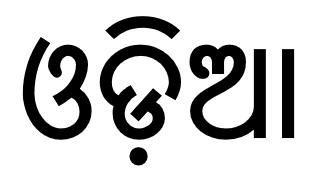
Odia is an Indo-Aryan language spoken in the Indian state of Odisha. It is the official language in Odisha, where native speakers make up 82% of the population, and it is also spoken in parts of West Bengal, Jharkhand, Andhra Pradesh and Chhattisgarh. Odia is one of the many official languages of India; it is the official language of Odisha and the second official language of Jharkhand. The language is also spoken by a sizeable population of 700,000 people in Chhattisgarh.

India is a federal union comprising 28 states and 8 union territories, with a total of 36 entities. The states and union territories are further subdivided into districts and smaller administrative divisions.

Wayanad is a district in the north-east of Indian state Kerala with administrative headquarters at the municipality of Kalpetta. It is the only plateau in Kerala. The Wayanad Plateau forms a continuation of the Mysore Plateau, the southern portion of Deccan Plateau. It is set high in the Western Ghats with altitudes ranging from 700 to 2100 meters. Vellari Mala, a 2,240 m (7,349 ft) high peak situated on the trijunction of Wayanad, Malappuram, and Kozhikode districts, is the highest point in Wayanad district. The district was formed on 1 November 1980 as the 12th district in Kerala, by carving out areas from Kozhikode and Kannur districts. An area of 885.92 km2 of the district is forested. Wayanad has three municipal towns—Kalpetta, Mananthavady and Sulthan Bathery. There are many indigenous tribes in this area. The Kabini River, a tributary of Kaveri River, originates at Wayanad. Wayanad district, along with the Chaliyar valley in neighbouring Nilambur in Malappuram district, is known for natural gold fields, which are also seen in other parts of the Nilgiri Biosphere Reserve. Chaliyar river, which is the fourth longest river of Kerala, originates on the Wayanad plateau. The historically important Edakkal Caves are located in Wayanad district.

Santali, Bengali: সাঁওতালী, Odia: ସାନ୍ତାଳୀ, Devanagari: सान्ताली, also known as Santal or Santhali, is the most widely-spoken language of the Munda subfamily of the Austroasiatic languages, related to Ho and Mundari, spoken mainly in the Indian states of Assam, Bihar, Jharkhand, Mizoram, Odisha, Tripura and West Bengal. It is a recognised regional language of India per the Eighth Schedule of the Indian Constitution. It is spoken by around 7.6 million people in India, Bangladesh, Bhutan and Nepal, making it the third most-spoken Austroasiatic language after Vietnamese and Khmer.

Howrah is a city in the Indian state of West Bengal. Howrah is located on the western bank of the Hooghly River opposite its twin city of Kolkata. Administratively it lies within Howrah district, and is the headquarters of the Howrah Sadar subdivision. It is a part of the area covered by the Kolkata Metropolitan Development Authority. Howrah is an important transportation hub and gateway to Kolkata and West Bengal.
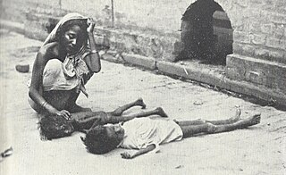
The Bengal famine of 1943 was a famine in the Bengal province of British India during World War II. An estimated 800,000 to 3.8 million Bengalis perished, out of a population of 60.3 million, from starvation, malaria and other diseases aggravated by malnutrition, population displacement, unsanitary conditions and lack of health care due to a combination of factors, including government policies, war-time disruption of food distribution, and an unusually high cyclone and flood. Millions were impoverished as the crisis overwhelmed large segments of the economy and catastrophically disrupted the social fabric. Eventually, families disintegrated; men sold their small farms and left home to look for work or to join the British Indian Army, and women and children became homeless migrants, often travelling to Calcutta or other large cities in search of organised relief. Some scholars characterise the famine as anthropogenic (man-made), asserting that wartime colonial policies exacerbated the crisis. Others argue that the famine was the result of natural causes.

Birbhum district is an administrative unit in the Indian state of West Bengal. It is the northernmost district of Burdwan division—one of the five administrative divisions of West Bengal. The district headquarters is in Suri. Other important cities are Bolpur, Rampurhat and Sainthia. Jamtara, Dumka and Pakur districts of the state of Jharkhand lie at the western border of this district; the border in other directions is covered by the districts of Bardhaman and Murshidabad of West Bengal.

Banda district is a district of Uttar Pradesh state of India, and Banda is the district headquarters. It is a part of Chitrakoot Division.

Rajkot district is one of the 33 districts of the Indian state of Gujarat. Located in Saurashtra peninsula, Rajkot city is the administrative headquarters of the district. It is the third-most advanced district in Gujarat and the fourth most populus.
Thoothukudi District is one of the 38 districts of Tamil Nadu state in southern India. The district was formed by bifurcation of Tirunelveli district on 20 October 1986. Thoothukudi is the district headquarters and largest city of the district. The district is known for fishing as well as pearl cultivation, with an abundance of pearls being found in the seas offshore. Thoothukudi district has many historical sites such as Adichanallur and the ancient trade port of Korkai.

Bhopal District is a district of Madhya Pradesh state in central India. The city of Bhopal serves as its administrative headquarters. The district is part of Bhopal Division.
The Dimasa language is a Sino-Tibetan language spoken by the Dimasa people of the Northeastern Indian states of Assam and Nagaland. The Dimasa language is known to Dimasas as "Grao-Dima" and it is similar to Boro, Kokborok and Garo languages.

Koduri Marakathamani Keeravani is an Indian music composer, record producer, singer, and lyricist who predominantly works in Telugu cinema. His accolades include an Academy Award, a Golden Globe Award, a LAFCA Award, a Critics' Choice Movie Award, a National Film Award, eight Filmfare Awards and eleven Nandi Awards. In 2023, the Government of India honoured him with the Padma Shri for his contributions towards Indian cinema.
The Greater Chennai Metropolitan Area, or simply the Chennai Metropolitan Area (CMA), is the third-most populous metropolitan area in India, the 22nd-most in Asia, and the 40th-most in the world. The CMA consists of the core city of Chennai, which is coterminous with the Chennai district, and its suburbs in Kanchipuram, Chengalpattu, Thiruvallur, and Ranipet districts. The Chennai Metropolitan Development Authority (CMDA) is the nodal agency that handles town planning and development within the metro area. Since 1974, an area encompassing 1,189 km2 (459 sq mi) around the city has been designated as the CMA and the CMDA has been designated as the authority to plan the growth of the city and the area around it. But in October 2022 the area of CMA was expanded five-fold to 5,904 km2 (2,280 sq mi).
Sümi, also Sema, is a Sino-Tibetan language spoken in Nagaland, India. It is spoken by the Sümi Naga people. It differs from every other Naga languages due to the presence of guttural sounds.

