| Ear Mountain | |
|---|---|
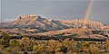
 East aspect | |
| Highest point | |
| Elevation | 8,560 ft (2,610 m) [1] |
| Prominence | 1,440 ft (440 m) [2] |
| Parent peak | Peak 9147 [2] |
| Isolation | 4.55 mi (7.32 km) [2] |
| Coordinates | 47°49′24″N112°41′24″W / 47.8232504°N 112.6900274°W [3] |
| Geography | |
 Ear Mountain Location in Montana  Ear Mountain Location in the United States | |
| Location | Teton County, Montana, U.S. |
| Parent range | Rocky Mountains Rocky Mountain Front |
| Topo map | USGS Ear Mountain |
Ear Mountain is an 8,560-foot (2,610-metre) mountain summit located in Teton County of the U.S. state of Montana. [3]