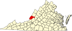
Earlehurst is an unincorporated community in Alleghany County, Virginia, United States.
Alleghany County is an American county located on the far western edge of Commonwealth of Virginia. It is bordered by the Allegheny Mountains, from which the county derives its name, and it is the northernmost part of the Roanoke Region. The county seat is Covington.
Virginia, officially the Commonwealth of Virginia, is a state in the Southeastern and Mid-Atlantic regions of the United States located between the Atlantic Coast and the Appalachian Mountains. Virginia is nicknamed the "Old Dominion" due to its status as the first English colonial possession established in mainland North America and "Mother of Presidents" because eight U.S. presidents were born there, more than any other state. The geography and climate of the Commonwealth are shaped by the Blue Ridge Mountains and the Chesapeake Bay, which provide habitat for much of its flora and fauna. The capital of the Commonwealth is Richmond; Virginia Beach is the most populous city, and Fairfax County is the most populous political subdivision. The Commonwealth's estimated population as of 2018 is over 8.5 million.
The United States of America (USA), commonly known as the United States or America, is a country composed of 50 states, a federal district, five major self-governing territories, and various possessions. At 3.8 million square miles, the United States is the world's third or fourth largest country by total area and is slightly smaller than the entire continent of Europe's 3.9 million square miles. With a population of over 327 million people, the U.S. is the third most populous country. The capital is Washington, D.C., and the largest city by population is New York City. Forty-eight states and the capital's federal district are contiguous in North America between Canada and Mexico. The State of Alaska is in the northwest corner of North America, bordered by Canada to the east and across the Bering Strait from Russia to the west. The State of Hawaii is an archipelago in the mid-Pacific Ocean. The U.S. territories are scattered about the Pacific Ocean and the Caribbean Sea, stretching across nine official time zones. The extremely diverse geography, climate, and wildlife of the United States make it one of the world's 17 megadiverse countries.
The climate in this area is characterized by hot, humid summers and generally mild to cool winters. According to the Köppen Climate Classification system, Earlehurst has a humid subtropical climate, abbreviated "Cfa" on climate maps. [1]
A humid subtropical climate is a zone of climate characterized by hot and humid summers, and mild winters. These climates normally lie on the southeast side of all continents, generally between latitudes 25° and 40° and are located poleward from adjacent tropical climates. While many subtropical climates tend to be located at or near coastal locations, in some cases they extend inland, most notably in China and the United States, where they exhibit more pronounced seasonal variations and sharper contrasts between summer and winter, as part of a gradient between the more tropical climates of the southern coasts of these countries and the more continental climates of China and the United States’ northern and central regions.
Salem is an independent city in the U.S. commonwealth of Virginia. As of the 2010 census, the population was 24,802. It is the county seat of Roanoke County, although the two are separate jurisdictions. The Bureau of Economic Analysis combines the city of Salem with Roanoke County for statistical purposes.
Clifton Forge is a town in Alleghany County, Virginia, United States which is part of the Roanoke Region. The population was 3,884 at the 2010 census. The Jackson River flows through the town, which as a result was once known as Jackson's River Station.
Camp Wood is a city in Real County, Texas, USA, in the Texas Hill Country, which is part of the Edwards Plateau. The population was 706 at the 2010 census.
Hallwood is a town in Accomack County, Virginia, in the United States. As of the 2010 census, the town population was 206.
Merrimac is a census-designated place (CDP) in Montgomery County, Virginia, United States. The population was 2,133 at the 2010 census. It is part of the Blacksburg–Christiansburg–Radford Metropolitan Statistical Area which encompasses all of Montgomery County and the city of Radford.
Warsaw is a town in and the county seat of Richmond County, Virginia, United States. The population was 1,512 at the 2010 census.
Glasgow is a town in Rockbridge County, Virginia, United States, at the confluence of the James and Maury Rivers. The population was 1,046 at the 2000 census.
Goshen is a town in Rockbridge County, Virginia, United States. The population was 406 at the 2000 census.
Falling Spring is a town in Greenbrier County, West Virginia, in the United States. It is also known as Renick from the name of its post office. The population was 211 at the 2010 census.
Hollins is a census-designated place (CDP) in Botetourt and Roanoke counties in the U.S. state of Virginia. Hollins covers much of the area known locally as "North County". The population was 14,673 at the 2010 census. It is part of the Roanoke Metropolitan Statistical Area. The area is also the home of Hollins University in addition to four properties listed on the National Register of Historic Places: the Black Horse Tavern-Bellvue Hotel and Office, Harshbarger House, the Hollins College Quadrangle, and Old Tombstone.
Lafayette is a census-designated place (CDP) between the cities of Roanoke and Christiansburg in eastern Montgomery County, southwest Virginia. The population as of the 2010 Census was 449. It is located adjacent to Elliston, at the confluence of the North and South Forks of the Roanoke River.
Randolph, formerly called Roanoke and Talcott, is a small unincorporated community in Charlotte County, Virginia, United States, near the Staunton River. Its elevation is 354 feet. The community is the home of Staunton River Battlefield State Park.
Oyster is a small unincorporated community on the Atlantic Coast of the Eastern Shore of the U.S. state of Virginia in Northampton County. It is at an elevation of 3 feet above sea level.
Iron Hill Springs is an unincorporated community in Alleghany County, Virginia, United States.
Arrington is a census-designated place (CDP) in Nelson County, Virginia, United States. The population as of the 2010 Census was 708. Harmony Hill Bed and Breakfast is the only lodging location in Arrington, run by innkeepers Wendie and Jay Fines.
Rockfish is an unincorporated community in Nelson County, Virginia, United States.
Butlers Fork is an unincorporated community in Caroline County, in the U.S. state of Virginia.
Fine Creek Mills is an unincorporated community in Powhatan County, in the U.S. state of Virginia.
Ashbys Corner is an unincorporated community in Rappahannock County, in the U.S. state of Virginia.
Royal Sunset High School is a continuation high school in Hayward, California, United States, and is part of the San Lorenzo Unified School District.
Coordinates: 37°40′09″N80°14′03″W / 37.66917°N 80.23417°W
A geographic coordinate system is a coordinate system that enables every location on Earth to be specified by a set of numbers, letters or symbols. The coordinates are often chosen such that one of the numbers represents a vertical position and two or three of the numbers represent a horizontal position; alternatively, a geographic position may be expressed in a combined three-dimensional Cartesian vector. A common choice of coordinates is latitude, longitude and elevation. To specify a location on a plane requires a map projection.
This Alleghany County, Virginia state location article is a stub. You can help Wikipedia by expanding it. |