Related Research Articles

Washington County is a county in the U.S. state of New York. As of the 2020 census, the population was 61,302. The county seat is Fort Edward. The county was named for U.S. President George Washington.

Two Buttes is a Statutory Town located in Baca County, Colorado, United States. The population was 34 at the 2020 census.

New Hempstead is a village in the town of Ramapo, Rockland County, New York, United States. It is located north of New Square, east of Wesley Hills, south of Pomona, and west of New City. The population was 5,132 at the 2010 census. Residents utilize the Spring Valley and New City post offices.

Wilton is a town in Saratoga County, New York, United States. The population was 17,361 at the 2020 census.
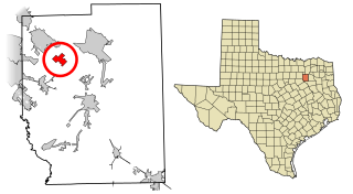
Talty is a city in Kaufman County, Texas, United States. Its population was 1,535 at the 2010 census, and in 2019 the estimated population was 2,760.
Wausaukee is a town in Marinette County, Wisconsin, United States. The estimated population was 573 in 2011. The Village of Wausaukee is located within the town. The unincorporated community of Cedarville is located partially in the town.

The Connecticut panhandle is the southwestern appendage of Connecticut, where it abuts New York State. It is contained entirely in Fairfield County and includes all of Greenwich, Stamford, New Canaan, and Darien, as well as parts of Norwalk and Wilton. It has some of the most expensive residential real estate in the United States.

The Mettawee River is a tributary of Lake Champlain in western Vermont and eastern New York in the United States, passing the town of Granville, New York. The river is particularly good for rapids and kayaking.
The Greenwich Country Day School is a co-educational, independent day school in Greenwich, Connecticut, United States, founded in 1926. As of 2019, it enrolled some 1190 students from nursery to 12th grade level. In November 2017, Greenwich Country Day acquired The Stanwich School, making it the only independent nursery through 12th grade co-educational school in Greenwich. The Head of School of GCDS is Adam Rohdie. The head of the high school is Chris Winters, former Greenwich High School principal.


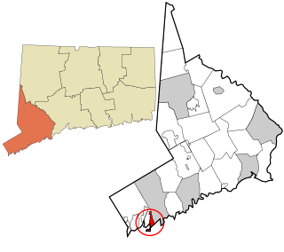
Byram is a neighborhood/section and census-designated place (CDP) in the town of Greenwich in Fairfield County, Connecticut, United States. It had a population of 4,146 at the 2010 census, and a census-estimated population of 4,216 in 2018. An endcap of Connecticut's Gold Coast, Byram is the southernmost point in the town of Greenwich and the U.S. state of Connecticut. It is separated from Port Chester, Westchester County, New York, by the Byram River. Byram was once known as East Port Chester.

Connecticut's 4th congressional district is a congressional district in the U.S. state of Connecticut. Located in the southwestern part of the state, the district is largely suburban and extends from Bridgeport, the largest city in the state, to Greenwich – an area largely coextensive with the Connecticut side of the New York metropolitan area. The district also extends inland, toward Danbury and toward the Lower Naugatuck Valley.

Riverside is a neighborhood/section in the town of Greenwich in Fairfield County, Connecticut, United States. As of the 2020 census, it had a population of 8,843.
Old Greenwich is an affluent coastal village in Fairfield County, Connecticut, United States. As of the 2010 census it had a population of 6,611.
Olmstedville is a hamlet in the town of Minerva in Essex County, New York, United States, in the Adirondack Park.
Battenville is a hamlet in Washington County on the south town line of Greenwich, New York, located on the Batten Kill in eastern New York. It is most known as the childhood home of Susan B. Anthony, who moved at the age of six with her family to Battenville from Adams, Massachusetts. The family later moved near Rochester in the western part of the state. Anthony became renowned as a women's rights activist and suffragist.

University Place is a short north-south thoroughfare in the Greenwich Village neighborhood of Manhattan, New York City, United States, which runs from Washington Square Park in the south as a continuation of Washington Square East, taking the position of Madison Avenue uptown, and terminates at East 14th Street just southwest of Union Square. Although the roadway continues north of 14th Street as Union Square West, traffic on the two streets run in opposite directions, both feeding into 14th Street. Until the late 1990s, University Place was a two-way street. The street contains numerous cafes, shops, and restaurants, many of which cater to students at NYU and The New School.
Siddonsburg is an unincorporated community in Monaghan Township, York County, Pennsylvania, United States. The community is located approximately two miles south of Messiah College. Siddonsburg was originally named Siddonstown. Siddonstown was established by Benjamin Siddons.
Fernando Salinas is a census-designated place (CDP) in Starr County, Texas, United States. This was a new CDP for the 2010 census with a population of 15.
References
Municipalities and communities of Washington County, New York, United States | ||
|---|---|---|
| Towns |  | |
| Villages | ||
| CDPs | ||
| Hamlets | ||
| Footnotes | ‡This populated place also has portions in an adjacent county or counties | |
43°08′45″N73°23′52″W / 43.14583°N 73.39778°W
| | This article about a location in Washington County, New York is a stub. You can help Wikipedia by expanding it. |