
Warren County is a county in the U.S. state of New York. As of the 2020 census, the population was 65,737. The county seat is Queensbury. The county is named in honor of General Joseph Warren, an American Revolutionary War hero of the Battle of Bunker Hill.

Glens Falls is a city in Warren County, New York, United States and is the central city of the Glens Falls Metropolitan Statistical Area. The population was 14,700 at the 2010 census. The name was given by Colonel Johannes Glen, the falls referring to a large waterfall in the Hudson River at the southern end of the city.
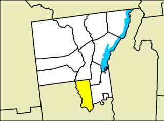
Lake Luzerne, formerly the Town of Fairfield and then Luzerne, is a town in southern Warren County, New York, United States. The town is located within the Adirondack Park. The town is part of the Glens Falls Metropolitan Statistical Area. Lake Luzerne is west of the city of Glens Falls. The town population was 3,347 at the 2010 census.
Queensbury is a town in Warren County, New York, United States. The population was 27,901 at the 2010 census.

The administrative divisions of New York are the various units of government that provide local services in the State of New York. The state is divided into boroughs, counties, cities, townships called "towns", and villages. They are municipal corporations, chartered (created) by the New York State Legislature, as under the New York Constitution the only body that can create governmental units is the state. All of them have their own governments, sometimes with no paid employees, that provide local services. Centers of population that are not incorporated and have no government or local services are designated hamlets. Whether a municipality is defined as a borough, city, town, or village is determined not by population or land area, but rather on the form of government selected by the residents and approved by the New York Legislature. Each type of local government is granted specific home rule powers by the New York State Constitution. There are still occasional changes as a village becomes a city, or a village dissolves, each of which requires legislative action. New York also has various corporate entities that provide local services and have their own administrative structures (governments), such as school and fire districts. These are not found in all counties. Except for its 10 Indian Reservations and the City of New York, every piece of land in the State is part of a city or town, which, with the exception of the city of Geneva, is part of one and only one county. Not every piece is in a village or city. A village is part of a town; cities are not part of towns, but have the powers of towns. A village can be a part of more than one town. A village cannot be part of a city.
New York State Route 32 (NY 32) is a north–south state highway that extends for 176.73 miles (284.42 km) through the Hudson Valley and Capital District regions of the U.S. state of New York. It is a two-lane surface road for nearly its entire length, with few divided and no limited-access sections. From Harriman to Albany, it is closely parallel to Interstate 87 (I-87) and U.S. Route 9W (US 9W), overlapping with the latter in several places.
New York State Route 9L (NY 9L) is a state highway in Warren County, New York, in the United States. The road is 18.58 miles (29.90 km) long and is a suffixed highway of U.S. Route 9 (US 9). NY 9L goes through three municipalities in Warren County: the city of Glens Falls, the town of Queensbury and the town of Lake George. It starts at an intersection with US 9 and NY 32 in Glens Falls and ends at a junction with US 9 and NY 9N in Lake George. NY 9L is a scenic route for people traveling to Lake George as the road provides many views of the lake. The route was assigned as part of the 1930 renumbering of state highways in New York along the path of an old military road originally built during the American Revolution.
New York State Route 149 (NY 149) is an east–west state highway that runs for 32.20 miles (51.82 km) through the Capital District of New York in the United States. It begins at exit 20 on the Adirondack Northway in the Warren County town of Queensbury and intersects U.S. Route 9 (US 9), US 4, and NY 22, among other routes, as it progresses eastward to its eastern end at the Vermont state line in the Washington County village of Granville. Here, the highway becomes Vermont Route 149 (VT 149) and continues for an additional 1.302 miles (2.095 km) to an intersection with VT 30 in Rutland County. Both NY 149 and VT 149 traverse mostly rural areas.
The Niagara Scenic Parkway is a 16.4-mile (26.39 km) long north–south highway in western Niagara County, New York, in the United States. Its southern terminus is at the LaSalle Expressway on the east bank of the Niagara River in Niagara Falls. The northern terminus is at New York State Route 18 (NY 18) at Four Mile Creek State Park in Porter near Lake Ontario. Originally, the parkway was one continuous road; however, due to low usage, a portion of the parkway near Niagara Falls was removed, separating the parkway into two sections. The length of the parkway is designated as New York State Route 957A by the New York State Department of Transportation (NYSDOT). A 1.16-mile (1.87 km) long spur connecting the Niagara Scenic Parkway to Fort Niagara State Park near Youngstown is designated as New York State Route 958A. Both reference route designations are unsigned.
New York State Route 26 (NY 26) is a north–south state highway that runs for 203.80 miles (327.98 km) through Central New York in the United States. Its southern terminus is located at the Pennsylvania state line south of the town of Vestal in Broome County, where it becomes Pennsylvania Route 267 (PA 267). Its northern terminus is located at a junction with NY 12 in the village of Alexandria Bay in Jefferson County. NY 26 serves three cities along its routing; one directly (Rome) and two via other roadways. NY 26 also intersects several other primary routes including I-81 in Barker, an overlap with U.S. Route 20 (US 20) in Madison, NY 12 in Lowville, and an overlap with US 11 in the Jefferson County town of Philadelphia.
New York State Route 254 (NY 254) is a state highway that extends for 6.01 miles (9.67 km) through Warren and Washington counties in the Capital District of New York in the United States. The route runs from exit 19 along the Adirondack Northway in Queensbury and follows Aviation Road, Quaker Road, and Lower Warren Street through Queensbury to Hudson Falls, where it terminates at an intersection with U.S. Route 4 (US 4) in the center of the village.

Kattskill Bay is a hamlet in the towns of Queensbury in Warren County and Fort Ann in Washington County in the state of New York, United States. The hamlet is located along the shore of Warner and Van Warmer Bays of Lake George. Kattskill Bay was part of the proposed East Lake George village. Pilot Knob Road is the major highway that runs through the hamlet. The hamlet is located at the base of Buck Mountain.

The Glens Falls Metropolitan Statistical Area, as defined by the United States Census Bureau, is an area consisting of two counties in Upstate New York, anchored by the city of Glens Falls. It is considered to be a part of the greater Capital District. As of the 2010 census, the MSA had a population of 128,942.

Hideout is a town in the northwestern corner of Wasatch County, Utah, United States, in the northern part of the state. Lying just to the north and east of Jordanelle Reservoir along Utah State Route 248 (SR-248), the town was incorporated in 2008 under a short-lived state law. The population was 656 at the 2010 census.

Independence is a town in Wasatch County, Utah, United States. Lying just east of U.S. Route 40 southeast of Heber City, Independence was incorporated in 2008 under a controversial, short-lived state law. The population was 164 at the 2010 census.
Interstate 781 (I-781) is an auxiliary Interstate Highway north of Watertown in Jefferson County, New York, in the United States. The route extends for 4.9 miles (7.9 km) from an interchange with I-81 in Pamelia to the main entrance of Fort Drum in Le Ray. It also has one intermediate interchange with U.S. Route 11 (US 11) just west of Fort Drum. I-781 is four lanes wide and serves as the principal travel corridor into and out of the post. The freeway is ceremoniously designated as the Paul Cerjan Memorial Highway in honor of Paul G. Cerjan, a late US Army Lieutenant General who oversaw a $1.2 billion expansion of Fort Drum in the 1980s.

Fort Ann is a town in Washington County, New York, United States. It is part of the Glens Falls Metropolitan Statistical Area. The town population was 6,417 at the 2000 census. The town contains a village, also called Fort Ann, located in its southeastern corner.
East Redmond was a short-lived town in King County, Washington that existed from 1956 to 1965. The town, then located to the east of Redmond in the Seattle metropolitan area, was formed as a result of a land use dispute between neighbors. East Redmond, with a population of fewer than 400 people, was found to have not met the state's minimum population requirement for incorporation and was dis-incorporated by a decision of the Washington Supreme Court in 1965.
St. George is a proposed city in Louisiana that was approved in a ballot initiative on October 12, 2019. Upon incorporation, it would become the fifth largest city in Louisiana and the second largest in East Baton Rouge Parish with a population of 86,316. The proposed city originates from a previously unincorporated area of East Baton Rouge Parish located southeast of the City of Baton Rouge.


