
German Valley is a village in Stephenson County, Illinois, United States. German Valley is located four miles south of U.S. Route 20 between Freeport and Rockford. German Valley had a population of 433 at the 2020 census, with a 2023 estimate of 424.

Lake Ann is a village in northeastern Benzie County in the U.S. state of Michigan. Part of Almira Township, Lake Ann is situated 10 miles (16 km) west of Traverse City, and largely dependent upon that city. The population of Lake Ann was 273 at the 2020 census.

Hanska is a city in Brown County, Minnesota, United States. The population was 402 at the 2010 census.
Ann Lake Township is a township in Kanabec County, Minnesota, United States. The population was 377 at the 2000 census.

Jamestown is a village in northeastern Moniteau County, Missouri, United States. The population was 386 at the 2010 census. It is part of the Jefferson City, Missouri Metropolitan Statistical Area.

Murray is a village in Cass County, Nebraska, United States. The population was 480 at the 2020 census.

Verdel is a village in Knox County, Nebraska, United States. The population was 30 at the 2010 census.
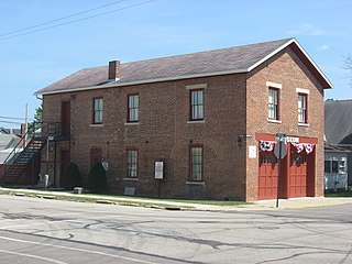
Hagaman, formerly Hagamans Mills, is a village in Montgomery County, New York, United States. The population was 1,292 at the 2010 census. It is named after Joseph Hagaman, the founding father.

Fort Shawnee is census-designated place (CDP) in Allen County, Ohio, United States. The population was 6,263 at the 2020 census. It is included in the Lima, Ohio Metropolitan Statistical Area. Fort Shawnee is adjacent to the city of Lima and the village of Cridersville in Auglaize County. In 2012, village residents voted to disincorporate the village. According to the United States Census Bureau, the village had a total area of 7.25 square miles (18.78 km2), of which 7.21 square miles (18.67 km2) is land and 0.04 square miles (0.10 km2) is water.

Pleasant City is a village in Guernsey County, Ohio, United States. The population was 400 at the 2020 census.

New Bloomington is a village in Marion County, Ohio, United States. The population was 413 at the 2020 census. New Bloomington is served by Elgin Local School District.
Covington is a village in Miami County, Ohio, United States. The population was 2,548 at the 2020 census. It is part of the Dayton Metropolitan Statistical Area. The village was incorporated as Covington in 1835 on the site of the 1793 Fort Rowdy.

Bolivar is a village in Tuscarawas County, Ohio, United States. The population was 1,000 at the 2020 census. Bolivar is also home to Fort Laurens, the only American Revolutionary War-era fort in what is now Ohio.

Pittsford is a town in Rutland County, Vermont, United States. As of the 2020 census, the town population was 2,862. Named for William Pitt, it has two picket forts used in the American Revolutionary War.

Brandon is a village in Fond du Lac County, Wisconsin, United States. The population was 879 at the 2010 census.

Bay City is a village on the Mississippi River in Pierce County, Wisconsin, United States. The population was 500 at the 2010 census.

Boaz is a village in Richland County, Wisconsin, United States. According to the 2010 census, the population of the village was 156.

Readstown is a village in Vernon County, Wisconsin, United States. The population was 376 at the 2020 census.

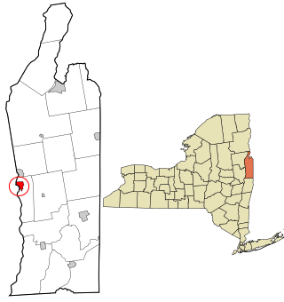
Fort Ann is a town in Washington County, New York, United States. It is part of the Glens Falls Metropolitan Statistical Area. The town population was 5,812 at the 2020 census. The town contains a village, also called Fort Ann, located in its southeastern corner.
Fort Edward is a village in Washington County, New York, United States. It is part of the Glens Falls Metropolitan Statistical Area. The village population was 3,375 at the 2010 census. The name is derived from the younger brother of King George III, Edward Augustus, Duke of York and Albany.

