
A ZIP Code is a system of postal codes used by the United States Postal Service (USPS). Introduced on July 1, 1963, the basic format consisted of five digits. In 1983, an extended ZIP+4 code was introduced; it included the five digits of the ZIP Code, followed by a hyphen and four digits that designated a more specific location.

Warren County is a county in the U.S. state of New York. As of the 2020 census, the population was 65,737. The county seat is Queensbury. The county was established in 1813 and is named in honor of General Joseph Warren, an American Revolutionary War hero of the Battle of Bunker Hill.
Fayette is a town in Seneca County, New York, United States. The population was 3,617 at the 2020 census. The town is in the north-central part of the county and is southeast of Geneva, New York.
Lake Luzerne, formerly the Town of Fairfield and then Luzerne, is a town in southern Warren County, New York, United States. The town is located within the Adirondack Park. The town is part of the Glens Falls Metropolitan Statistical Area. Lake Luzerne is west of the city of Glens Falls. The town population was 3,347 at the 2010 census.
Queensbury is a town in Warren County, New York, United States. The population was 27,901 at the 2010 census.

Huron is a town in Wayne County, New York, United States. The population was 2,118 at the 2010 census. The town is named after the Huron Indians.
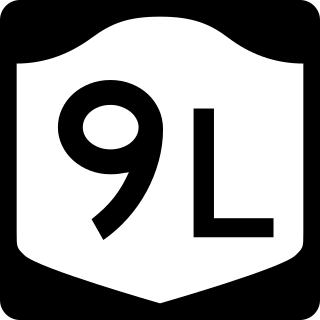
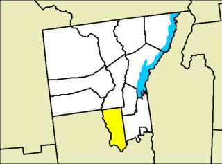
New York State Route 9L (NY 9L) is a state highway in Warren County, New York, in the United States. The road is 18.58 miles (29.90 km) long and is a suffixed highway of U.S. Route 9 (US 9). NY 9L goes through three municipalities in Warren County: the city of Glens Falls, the town of Queensbury and the town of Lake George. It starts at an intersection with US 9 and NY 32 in Glens Falls and ends at a junction with US 9 and NY 9N in Lake George. NY 9L is a scenic route for people traveling to Lake George as the road provides many views of the lake. The route was assigned as part of the 1930 renumbering of state highways in New York along the path of an old military road originally built during the American Revolution.

New York State Route 149 (NY 149) is an east–west state highway that runs for 32.20 miles (51.82 km) through the Capital District of New York in the United States. It begins at exit 20 on the Adirondack Northway in the Warren County town of Queensbury and intersects U.S. Route 9 (US 9), US 4, and NY 22, among other routes, as it progresses eastward to its eastern end at the Vermont state line in the Washington County village of Granville. Here, the highway becomes Vermont Route 149 (VT 149) and continues for an additional 1.302 miles (2.095 km) to an intersection with VT 30 in Rutland County. Both NY 149 and VT 149 traverse mostly rural areas.

East Lake George is a hamlet within the towns of Queensbury and Fort Ann in the U.S. state of New York. East Lake George attempted to incorporate as a village, a measure rejected by voters in 2010.

Lake George is a town in Warren County, New York, United States. The population was 3,578 at the 2000 census. The town is named after the lake, Lake George. The town is part of the Glens Falls Metropolitan Statistical Area.

Fort Ann is a town in Washington County, New York, United States. It is part of the Glens Falls Metropolitan Statistical Area. The town population was 6,417 at the 2000 census. The town contains a village, also called Fort Ann, located in its southeastern corner.

Halcottsville is a hamlet in the town of Middletown, Delaware County, New York, United States, on the south shore of Wawaka Lake. It was named for John Halcott (1758-1831), a Revolutionary War soldier from Delaware County. He resided with his son Thomas in Halcottsville until his demise. Halcottsville is located on the East Branch Delaware River and New York State Route 30 5.6 miles (9.0 km) northeast of Margaretville. Halcottsville has a post office with ZIP code 12438. The hamlet has a stop on the excursion Delaware & Ulster Railroad which originates in nearby Arkville and extends north to the village of Roxbury.
Springfield Center is a hamlet in the town of Springfield, Otsego County, New York, United States. According to the 2010 US census, The location of Springfield Center had a population of 402. Springfield Center is located on New York State Route 80, 9.2 miles (14.8 km) north-northeast of the Village of Cooperstown. Springfield Center has a post office with ZIP code 13468, which opened on July 16, 1850.
Diamond Point is a hamlet in Warren County, New York, United States. The community is located along the western shore of Lake George and New York State Route 9N, 3.9 miles (6.3 km) north-northeast of the village of Lake George. Diamond Point has a post office with ZIP code 12824, which opened on September 6, 1877.
Adirondack is a hamlet in Warren County, New York, United States. The community is located on Schroon Lake near the northern border of the county, 32 miles (51 km) north of Glens Falls. Adirondack has a post office with ZIP code 12808.
Cleverdale is a hamlet in Warren County, New York, United States. The community is located on a peninsula along the south shore of Lake George, 5 miles (8.0 km) northeast of the village of Lake George. Cleverdale has a post office with ZIP code 12820.
Pilot Knob is a hamlet in Washington and Warren counties, New York, United States. The community is located on the eastern shore of Lake George; while the Washington-Warren county line largely follows the shoreline, placing most of the community in Washington County, a small portion lies on the Warren County side.
Bernhards Bay is a hamlet in Oswego County, New York, United States. The community is located on the north shore of Oneida Lake along New York State Route 49, 2.5 miles (4.0 km) west of Cleveland. Bernhards Bay has a post office with ZIP code 13028.


