Eastmont, Oakland, California

Last updated

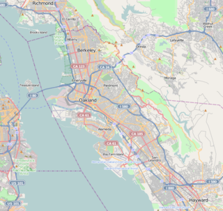
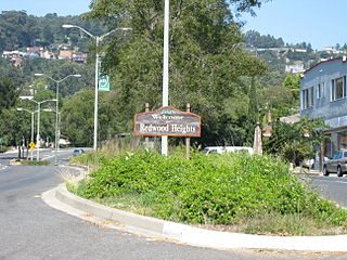
Coordinates: 37°46′09″N122°10′20″W / 37.76917°N 122.17222°W / 37.76917; -122.17222 Eastmont is a neighborhood in Oakland, the county seat of Alameda County, California. It lies at an elevation of 95 feet (29 m). It was formerly an unincorporated community.

Geographic coordinate system Coordinate system

A geographic coordinate system is a coordinate system that enables every location on Earth to be specified by a set of numbers, letters or symbols. The coordinates are often chosen such that one of the numbers represents a vertical position and two or three of the numbers represent a horizontal position; alternatively, a geographic position may be expressed in a combined three-dimensional Cartesian vector. A common choice of coordinates is latitude, longitude and elevation. To specify a location on a plane requires a map projection.

Oakland, California City in California, United States

Oakland is the largest city and the county seat of Alameda County, California, United States. A major West Coast port city, Oakland is the largest city in the East Bay region of the San Francisco Bay Area, the third largest city overall in the San Francisco Bay Area, the eighth most populated city in California, and the 45th largest city in the United States. With a population of 425,195 as of 2017, it serves as a trade center for the San Francisco Bay Area; its Port of Oakland is the busiest port in the San Francisco Bay, the entirety of Northern California, and the fifth busiest in the United States of America. An act to incorporate the city was passed on May 4, 1852, and incorporation was later approved on March 25, 1854, which officially made Oakland a city. Oakland is a charter city.

Alameda County, California County in California

Alameda County is a county in the state of California in the United States. As of the 2010 census, the population was 1,510,271, making it the 7th-most populous county in the state. The county seat is Oakland. Alameda County is included in the San Francisco Bay Area, occupying much of the East Bay region.

The Eastmont Town Center shopping mall and social services center is located in the neighborhood, at 73rd Avenue where Foothill and MacArthur Boulevards meet. The name of MacArthur Boulevard was changed from Excelsior in honor of World War II hero General of the Army Douglas MacArthur.

Eastmont Town Center

Eastmont Town Center is a shopping mall and social services hub located on 33 acres (130,000 m2) bounded by Foothill Boulevard, Bancroft and 73rd Avenues, and Church Street, in the Frick neighborhood of East Oakland. The mall opened in 1970 on the site of a 1920s-era Chevrolet automobile factory called Oakland Assembly. Architect William Pereira designed the building. It is physically almost next to, and by entry access a few blocks away from the similarly sized Evergreen Cemetery.

General of the Army (United States) Second highest possible rank in the United States Army

General of the Army is a five-star general officer and the second highest possible rank in the United States Army. A General of the Army ranks immediately above a general and is equivalent to a Fleet Admiral and a General of the Air Force. There is no established equivalent five-star rank in the other federal uniformed services. Often called a "five-star general", the rank of General of the Army has historically been reserved for wartime use and is not currently active in the U.S. military. The General of the Army insignia consisted of five 3/8th inch stars in a pentagonal pattern, with points touching. The insignia is paired with the gold and enameled United States Coat of Arms on service coat shoulder loops. The silver colored five-star metal insignia alone would be worn for use as a collar insignia of grade and on the garrison cap. Soft shoulder epaulettes with five 7/16th inch stars in silver thread and gold-threaded United States Coat of Arms on green cloth were worn with shirts and sweaters.

Douglas MacArthur U.S. Army general of the army, field marshal of the Army of the Philippines

Douglas MacArthur was an American five-star general and Field Marshal of the Philippine Army. He was Chief of Staff of the United States Army during the 1930s and played a prominent role in the Pacific theater during World War II. He received the Medal of Honor for his service in the Philippines Campaign, which made him and his father Arthur MacArthur Jr. the first father and son to be awarded the medal. He was one of only five to rise to the rank of General of the Army in the US Army, and the only one conferred the rank of field marshal in the Philippine Army.

On March 21, 2009, 2 blocks south of the mall, four Oakland police officers were killed, along with their assailant. This was among the deadliest attacks on law enforcement in California history. [1]

Four Oakland, California police officers were fatally shot on March 21, 2009, by Lovelle Mixon, a convicted felon wanted on a no-bail warrant for a parole violation, who had also committed a series of violent rapes linked to him by DNA. Mixon shot and killed two Oakland police officers during a routine traffic stop. After escaping on foot to the nearby apartment of his sister, Mixon shot and killed two police SWAT team officers attempting to apprehend him. Mixon was killed as other officers on the team returned fire.

Evergreen Cemetery is located there, and is the burial place for unclaimed victims of the Jonestown mass killing.

Evergreen Cemetery (Oakland, California) cemetery in Oakland, California

Evergreen Cemetery is a cemetery, crematorium and mausoleum located in Oakland, Alameda County, California, near the Eastmont Town Center and Mills College. The cemetery is on a small hill, with a large combined mausoleum, crematorium and chapel at the top of the hill. It is the second largest cemetery in Oakland, after the Mountain View Cemetery and Saint Mary Cemetery complex. It is full, and closed to new interments, but still operates a crematorium.

Jonestown former community established by the Peoples Temple

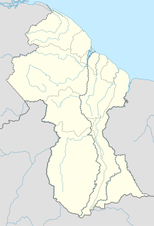
The Peoples Temple Agricultural Project, better known by its informal name "Jonestown", was a remote settlement established by the Peoples Temple, a predominantly African American cult under the leadership of their leader Jim Jones, in northwestern Guyana. It became internationally known when, on November 18, 1978, a total of 918 people died in the settlement, at the nearby airstrip in Port Kaituma, and at a Temple-run building in Georgetown, Guyana's capital city. The name of the settlement became synonymous with the incidents at those locations.

Related Research Articles

Elmhurst is a residential neighborhood in the southernmost part of Oakland, California. Originally a separate town, it was annexed by Oakland in 1909, and today is considered part of East Oakland. It lies at an elevation of 39 feet. It contains the Eastmont Town Center.

Laurel, Oakland, California Neighborhood of Oakland in Alameda, California, United States

The LaurelDistrict is one of the many culturally diverse neighborhoods in Oakland, California. It is situated between the foot of the Oakland hills and Mills College. It lies at an elevation of 226 feet. At the heart of the neighborhood lies MacArthur Blvd., a bustling shopping area with annual festivals and many local shops. The main street of the Laurel District is MacArthur Blvd., with the northwest end at 35th Avenue, and the southeast end at High Street.

Adams Point, Oakland, California Neighborhood of Oakland in Alameda, California, United States

Adams Point is a neighborhood of Oakland, California. It is located on the northern shore of Lake Merritt, directly adjacent to Downtown Oakland and the Grand Lake district. It is a triangle bounded by Grand Avenue on the south, Harrison Street on the northwest, and the MacArthur Freeway on the northeast. It lies at an elevation of 79 feet. Neighborhood landmarks include the Veteran's Memorial Building, the Earl Warren House, the art deco Bellevue-Staten Building, Lakeside Park, one of Oakland's larger parks, and Children's Fairyland, which is in the park.

Maxwell Park, Oakland, California Neighborhood of Oakland in Alameda, California, United States

Maxwell Park is a neighborhood in Oakland, California located in the foothills of the city. It is geographically bordered by MacArthur Blvd, High Street, Trask Street, Foothill Blvd, and 55th Avenue and is adjacent to Mills College, I-580, Brookdale Park, and the Fairfax neighborhood. It lies at an elevation of from 138 feet to its highest point of 266 feet on Knowland Ave.

Temescal, Oakland, California Neighborhood of Oakland in Alameda, California, United States

Temescal is one of the oldest neighborhoods in Oakland, California, located in North Oakland, and centered on Telegraph Avenue. The neighborhood derives its name from Temescal Creek, a significant watercourse in the city.

Dimond District, Oakland, California Neighborhood of Oakland in Alameda, California, United States

The Dimond District is a neighborhood centered on the intersection of MacArthur Boulevard and Fruitvale Avenue in East Oakland, Oakland, California, in the United States. It is located about two miles east of Lake Merritt, north of the Fruitvale District, and west of the Laurel District. It lies at an elevation of 213 feet. Dimond's ZIP code is 94602. It is a multicultural neighborhood where the hills meet the flatlands and is a unique melting pot of cultures and social classes. Dimond Park is located in the district.

Glenview, Oakland, California neighborhood in Alameda, California, United States

Glenview is a neighborhood in Oakland, California developed in the early decades of the 20th century, mostly with mid-sized 2 and 3-bedroom craftsman bungalows. The neighborhood lies in the Oakland foothills, bordering Dimond Park on the eastern side of the district, and Park Boulevard on the northwestern side. The upper portion of the neighborhood sits on the west side of Park Boulevard and is bordered by the Trestle Glen neighborhood as well as the City of Piedmont. Park Boulevard, as the neighborhood spine, also serves as the local shopping node, with a number of convenience shops and several restaurants stretching a few blocks. To the south, the neighborhood is delimited by MacArthur Blvd and the I-580 freeway.

Redwood Heights, Oakland, California Neighborhood of Oakland in Alameda, California, United States

Redwood Heights is a mostly middle-class and highly diverse residential neighborhood in the hills of Oakland, California. It is centered on Redwood Road, which was once a logging road. Currently, Redwood Road is the designation for 35th Avenue starting about a mile north of MacArthur Boulevard between Victor Avenue and the Warren Freeway. It includes Redwood Heights Elementary School and a recreation center that doubles as an after-school daycare. It lies at an elevation of 476 feet.

Serramonte human settlement in United States of America

Serramonte is a large 1960s residential neighborhood on the border of Daly City and Colma in the suburbs south of San Francisco, California, that is also home to numerous shopping malls, strip malls, and big box retailers. The nexus of Serramonte is Serramonte Center, originally opened in 1968, near the intersection of State Route 1 and Interstate 280, in the triangle formed by Callan Boulevard, Serramonte Boulevard, and Junipero Serra Boulevard which originally opened in 1968.

Fairmede-Hilltop, Richmond, California human settlement in United States of America

Fairmede-Hilltop, more commonly known simply as Hilltop, is a neighborhood located in the northeastern area of Richmond, California.

Crocker Highlands, a neighborhood of Oakland, California, overflows with an abundance of character and charm, described as having "the genteel ambiance of an old Hollywood movie set," is one of several distinct neighborhoods comprising a larger area collectively known as the "Lower Hills" that lies in between the 580 and 13 freeways.

Oakland Public Library library

The Oakland Public Library is the public library in Oakland, California. Opened in 1878, the Oakland Public Library currently serves the city of Oakland, along with neighboring smaller cities Emeryville and Piedmont. The Oakland Public Library has the largest collection of any public library in the East Bay, featuring approximately 1.5 million items. It consists of a main library located in downtown Oakland, and 16 branch libraries throughout the city.

Downtown Oakland central business district of Oakland, California

Downtown Oakland is the central business district of Oakland, California, United States; roughly bounded by both the Oakland Estuary and Interstate 880 on the southwest, Interstate 980 on the northwest, Grand Avenue on the northeast, and Lake Merritt on the east.

Millsmont, Oakland, California human settlement in United States of America

The Millsmont neighborhood located in the foothills of Oakland, California encompasses the area of East Oakland to the south and east of Mills College. Seminary Avenue is considered the northern border, and Edwards Avenue the approximate southern border; MacArthur Boulevard bounds it to the west, and Interstate 580 to the east. It lies at an elevation of 239 feet.

Sobrante Park is a neighborhood located in East Oakland, California, which is partially separated from the rest of the city by two railroad tracks and San Leandro Creek. It was built shortly after World War II, first as a White-Only Lockout and then gradually becoming a White flight red-zone in the mid to late 50's, and in the early 60's it became a working-class black neighborhood. It was projected by planners that there would be no in-road into SanLeandro's Davis St. residential area which was developed during the same period.

International Boulevard, East 14th Street, and Mission Boulevard are a major road in Alameda County, California. The section now known as International Boulevard was also named East 14th Street until 1996, owing to its position in the East Oakland grid plan; though fully deprecated within the city of Oakland today, this name is still commonly used, especially in casual speech. Mission Boulevard is so named as number 43300 is the location of Mission San José.

San Antonio, Oakland, California Neighborhood of Oakland in Alameda, California, United States

San Antonio is a large district in Oakland, California, encompassing the land east of Lake Merritt to Sausal Creek. It is one of the most diverse areas of the city. It takes its name from Rancho San Antonio, the name of the land as granted to Luís María Peralta by the last Spanish governor of California.

Eastmont, Washington CDP in Washington, United States

Eastmont is a census-designated place (CDP) in Snohomish County, Washington, United States. The population was 20,101 at the 2010 census. Eastmont is one of two CDPs that were created out of the former Seattle Hill-Silver Firs CDP in 2010, the other being Silver Firs. Eastmont is the location of Community Transit's Eastmont Park & Ride, which is serviced by Sound Transit Express route 513.

References