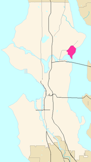
Laurelhurst is a residential neighborhood in Seattle, Washington, USA. It is bounded on the northeast by Ivanhoe Place N.E., beyond which is Windermere; on the northwest by Sand Point Way N.E. and N.E. 45th Street, beyond which are Hawthorne Hills, Ravenna, and University Village; on the west by Mary Gates Memorial Drive N.E., beyond which is the East Campus of the University of Washington; on the southwest by Union Bay; and on the east by Lake Washington. Seattle Children's Hospital is located in its northwest corner. Once a seasonal campground of the Duwamish people, the neightborhood has been a part of Seattle since its annexation in 1910.

Haight Street, in San Francisco, is the principal street in San Francisco's Haight-Ashbury district, also known as the Upper Haight due to its elevation. The street stretches from Market Street, through the Lower Haight neighborhood, to Stanyan Street in the Upper Haight, at Golden Gate Park. In most blocks it is residential, but in the Upper and Lower Haight it is also a neighborhood shopping street, with residences above the ground floor shops. It is named after California pioneer and exchange banker Henry Haight (1820–1869).

Balboa Park is a neighborhood and public park in San Francisco, California. It was created in 1909, and parts of it were built over time. The neighborhood is located between Mission Street and Interstate 280 north of Geneva Avenue, and the park is located on San Jose Avenue, north of Ocean Avenue. Inside of the park there is a public swimming pool, a children's playground, a stadium, baseball diamonds, tennis courts, and the Ingleside police station. The only public soccer-specific stadium, Boxer Stadium, is located within Balboa Park.

The LaurelDistrict is one of the many culturally diverse neighborhoods in Oakland, California. It is situated between the foot of the Oakland hills and Mills College. It lies at an elevation of 226 feet. At the heart of the neighborhood lies MacArthur Blvd., a bustling shopping area with annual festivals and many local shops. The main street of the Laurel District is MacArthur Blvd., with the northwest end at 35th Avenue, and the southeast end at High Street.

Grass Valley is a neighborhood in Oakland, California. Located in East Oakland in the hills east of Bishop O'Dowd High School and the Oakland Zoo. It straddles upper Golf Links Road and lies just west of Skyline Road's end. It is home to Fire Station #28, Grass Valley Elementary School and East Bay Bible Church.
Castilleja School is an independent school for girls in grades six through twelve, located in Palo Alto, in the U.S. state of California. Castilleja is the only non-sectarian all-girls middle and high school in the San Francisco Bay Area. The faculty consists of approximately 70 full-time and part-time women and men. Castilleja is a member of the California Association of Independent Schools and the National Coalition of Girls' Schools.
Pacific Bay Christian School, formerly Alma Heights Christian Academy, is a private Christian elementary, middle and high school in Pacifica, California.

Maxwell Park is a neighborhood in Oakland, California located in the foothills of the city. It is geographically bordered by MacArthur Blvd, High Street, Trask Street, Foothill Blvd, and 55th Avenue and is adjacent to Mills College, I-580, Brookdale Park, and the Fairfax neighborhood. It lies at an elevation of from 138 feet to its highest point of 266 feet on Knowland Ave.
Oakmore is a neighborhood in Oakland, California located east of Park Boulevard and north of Dimond Park. This neighborhood was built in the 1920s and 1930s for people who worked in San Francisco and took the Key Route to work. The Key System was a primary user of the Leimert Bridge, which connects Oakmore to Park Boulevard.
Northwest Heights is a neighborhood on the west side of Portland's West Hills. The neighborhood’s main thoroughfare is NW Skyline Boulevard, which snakes along the spine of the hills, with pockets of residential development cascading down the slopes. The neighborhood is close to the dining, shopping, and entertainment of Northwest. A short distance in the other direction is Forest Park, a vast tract of urban wilderness.

Hayhurst is a neighborhood in the southwest section of Portland, Oregon, on the border with Washington County. It borders Raleigh Hills and Beaverton, and the Portland neighborhoods of Bridlemile, Hillsdale, and Maplewood and Multnomah.

Cedar Park is a neighborhood in the Lake City district of Seattle, Washington. The name generally refers to the residential neighborhoods east of Lake City adjoining Lake Washington.

Cathedral Hill is a neighborhood and a hill, in the Western Addition district of San Francisco, California.
Piedmont Pines is a wealthy, heavily residential district in Oakland, California. It is generally bounded by Highway 13 to the west, Shepherd Canyon Rd. to the north, Skyline Dr. to the east, and Joaquin Miller Park to the south. Two Oakland public schools are included in the area, Montera Middle School and Joaquin Miller Elementary School. There is no business section in Piedmont Pines. Although listed as a distinct district, realtors-architects, city government, and many Piedmont Pines residents have long considered the neighborhood as part of the larger Montclair district. Piedmont Pines is relatively remote from the city center and generally less known than Montclair; many Oaklanders do not seem to know of Piedmont Pines and consider this area to be part of the Montclair district, given that architecturally, geographically, demographically, and economically, the two affluent areas are virtually indistinguishable.
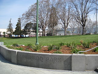
The Bushrod Park neighborhood in North Oakland, Oakland, California is an area surrounding its namesake park, and bounded by Martin Luther King, Jr. Way to the west, Claremont Avenue to the east, Highway 24 to the south, and the Berkeley border to the north. It borders the neighborhoods of Sante Fe to the west, Fairview Park to the east, and Temescal and Shafter to the south and southeast, respectively. Notable landmarks include the Bushrod Park ballfields and the former Bushrod Washington Elementary School, which share adjoining land on a large greenbelt and open space in the heart of the neighborhood.

Broadway is an east-west street in San Francisco that runs from The Embarcadero to the Pacific Heights neighborhood. The neon-lined stretch of Broadway through North Beach was historically the city's red-light district, home to strip clubs and other adult businesses, as well as many nightclubs and bars, and has been featured in several films and television shows. The street is home to several notable venues, such as the Showgirls theater, the Broadway Tunnel, Convent of the Sacred Heart High School and the City Lights Bookstore. West of the Broadway Tunnel, Broadway becomes more and more residential, moving from multiple dwelling units into two of the City's wealthier neighborhoods, Cow Hollow and Pacific Heights. It ends at Lyon Street and the Presidio which is gated to vehicular traffic.
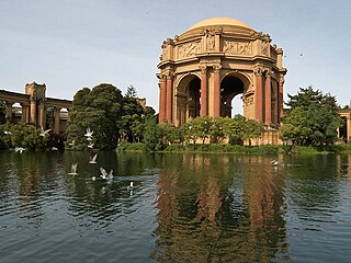
The Marina District is a neighborhood located in San Francisco, California. The neighborhood sits on the site of the 1915 Panama–Pacific International Exposition, staged after the 1906 San Francisco earthquake to celebrate the reemergence of the city. Aside from the Palace of Fine Arts (POFA), all other buildings were demolished to make the current neighborhood. The Marina currently has the highest non-Hispanic white resident percentage of any recognized neighborhood in San Francisco.
The Elmwood District is a neighborhood of the City of Berkeley, California. It is primarily residential, with a small commercial area. The district does not have set lines of demarcation, but is focused around College and Ashby Avenues. The most extreme definitions of the district's boundaries do not extend past Telegraph Avenue to the west, Dwight Way to the north, or the Oakland city limit to the south. Elmwood was a streetcar suburb that was developed in the 1900s housing boom following the 1906 earthquake.
Laurel Heights is a neighborhood of San Francisco, California.
Barack Obama Academy is a small alternative middle school in Oakland, California. It is part of the Oakland Unified School District. It became notable as the first middle school in the United States to be officially named or renamed after US President Barack Obama in March 2009. The middle school, which opened in 2007, was formerly known as the Alternative Learning Community. The name change was prompted by the school's students.


