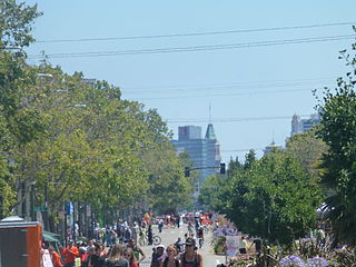
The Golden Gate neighborhood of Oakland, California is located in the northwest corner of the city, east of Emeryville and south of Berkeley. It includes the Golden Gate Shopping District, the stretch of San Pablo Avenue between 53rd Street on the south, and the Oakland-Berkeley border at 67th Street to the north. The neighborhood includes the area from a few blocks west of San Pablo Avenue to Adeline Street on the east.

The Laurel District is a diverse residential and commercial neighborhood in Oakland, California. encompassing the blocks northeast of Interstate 580 between High Street and 35th Avenue. It lies at an elevation of 226 feet, and is bordered by the Allendale neighborhood to the west, the Redwood Heights neighborhood to the east, the Dimond District to the north, and the Maxwell Park neighborhood to the south. At the heart of the neighborhood lies MacArthur Blvd., a bustling shopping area with annual festivals and many local shops.

West Oakland is a neighborhood situated in the northwestern corner of Oakland, California, United States, situated west of Downtown Oakland, south of Emeryville, and north of Alameda. The neighborhood is located along the waterfront at the Port of Oakland and at the eastern end of the San Francisco–Oakland Bay Bridge. It lies at an elevation of 13 feet.
Fruitvale is a neighborhood in Oakland, California, United States. It is located approximately 4 miles (6.44 km) southeast of Downtown, and is home to the city's largest Hispanic population, with Hispanics constituting 53.8% of Fruitvale's population. Fruitvale's ZIP code is 94601. It lies at an elevation of 49 feet.

Adams Point is a neighborhood of Oakland, California. It is located on the northern shore of Lake Merritt, directly adjacent to Downtown Oakland and the Grand Lake district. It is a triangle bounded by Grand Avenue on the south, Harrison Street on the northwest, and the MacArthur Freeway on the northeast. It lies at an elevation of 79 feet. Neighborhood landmarks include the Veteran's Memorial Building, the Earl Warren House, the art deco Bellevue-Staten Building, Lakeside Park, one of Oakland's larger parks, and Children's Fairyland, which is in the park.

Maxwell Park is a neighborhood in Oakland, California located in the foothills of the city. It is geographically bordered by MacArthur Boulevard, High Street, Trask Street, Foothill Boulevard, and 55th Avenue and is adjacent to Mills College, I-580, Brookdale Park, and the Fairfax neighborhood. It lies at an elevation of from 138 feet to its highest point of 266 feet on Knowland Ave.
Oakland City Center is an office, shopping and hotel complex in Downtown Oakland, Oakland, California. The complex is the product of a redevelopment project begun in the late 1950s. It covers twelve city blocks between Broadway on the east, Martin Luther King Jr. Way on the west, Frank H. Ogawa Plaza on 14th Street on the north side of the complex and the Oakland Convention Center and Marriott Hotel extend south to 10th Street. An hourly parking garage is located beneath the complex's shopping mall. The mall features an upscale fitness and racquet club, in addition to numerous take-out restaurants and other stores. The complex is served by the 12th Street/Oakland City Center BART station.

Old Oakland is a historic district in downtown Oakland, California. The area is located on the northwest side of Broadway, between the City Center complex and the Jack London Square district, and across Broadway from Chinatown.

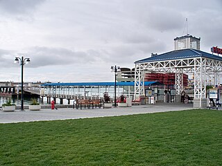
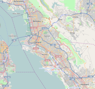
The Berkeley Marina is the westernmost portion of the city of Berkeley, California, located west of the Eastshore Freeway at the foot of University Avenue on San Francisco Bay. Narrowly speaking, "Berkeley Marina" refers only to the city marina, but in common usage, it applies more generally to the surrounding area.
The Cypress Street Viaduct, often referred to as the Cypress Structure or the Cypress Freeway, was a 1.6-mile-long (2.5 km), raised two-deck, multi-lane freeway constructed of reinforced concrete that was originally part of the Nimitz Freeway in Oakland, California.

The Oakland Estuary is the strait in the San Francisco Bay Area, California, separating the cities of Oakland and Alameda and the Alameda Island from the East Bay mainland. On its western end, it connects to San Francisco Bay proper, while its eastern end connects to San Leandro Bay.
The Jack London District, also called the Loft District, is a neighborhood of Oakland, California, USA, that occupies the region south of the Nimitz Freeway along The Embarcadero, between Adeline and Lake Merritt Channel. It includes and surrounds the Jack London Square shopping and tourist area, as well as the Warehouse District north of the Oakland Amtrak Station. The area has a long history of industrial and warehouse land use. Since the late 1990s, the area has seen residential redevelopment.

Middle Harbor Shoreline Park (MHSP) is located on San Francisco Bay and the Port of Oakland entrance channel, west of downtown Oakland, California. It is owned and operated by the Port of Oakland. The park entrance is at the intersection of 7th Street and Middle Harbor Road. It is open seven days a week from 8 a.m. to dusk.

Oakland Point, or Gibbons' Point, was a small promontory formerly on the eastern shore of San Francisco Bay in West Oakland, California. It was located in the vicinity of what is now the Port of Oakland shipping terminal.
Ghost Town is the informal name of the Foster Hoover Historic District neighborhood in West Oakland, Oakland, California.
Acorn or Acorn Projects are a series of housing projects in the Acorn Redevelopment Project Area or the Acorn neighborhood of West Oakland. Acorn, also known as "The Corns" or the "Cornfields", neighbors a wide variety of public housing. It is bordered by the high rise City Towers Apartments and low rise Mohr Apartments to the South, Cypress Village to the West, Market Street to the east and 10th Street to the north.
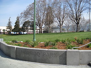
The Bushrod neighborhood in North Oakland, Oakland, California is an area surrounding its namesake park, and bounded by Martin Luther King, Jr. Way to the west, Claremont Avenue to the east, Highway 24 to the south, and the Berkeley border to the north. It borders the neighborhoods of Santa Fe to the west, Fairview Park to the east, and Temescal and Shafter to the south and southeast, respectively. Notable landmarks include the Bushrod Park ballfields and the former Bushrod Washington Elementary School, which share adjoining land on a large greenbelt and open space in the heart of the neighborhood.
San Antonio is a large district in Oakland, California, encompassing the land east of Lake Merritt to Sausal Creek. It is one of the most diverse areas of the city. It takes its name from Rancho San Antonio, the name of the land as granted to Luís María Peralta by the last Spanish governor of California.
Southside, also known by the older names South of Campus or South Campus, is a neighborhood in Berkeley, California. Southside is located directly south of and adjacent to the University of California, Berkeley campus. Because of the large student presence in the neighborhood, proximity to Sproul Plaza, and history of the area, Southside is the neighborhood most closely associated with the university.
The Cypress Village housing projects are a series of housing complexes stretching from 10th Street to 14th Street and Kirkham Way. Cypress is located in between the Acorn neighborhood and Lower Bottoms neighborhood in West Oakland. Cypress Village is one of the three housing projects in West Oakland, along with the Campbell Village Court and the Acorn Projects.