
Telegraph Avenue is a street that begins, at its southernmost point, in the midst of the historic downtown district of Oakland, California, and ends, at its northernmost point, at the southern edge of the University of California, Berkeley campus in Berkeley, California. It is approximately 4.5 miles (7 km) in length.
Interstate 395 (I-395) is an Interstate Highway in the U.S. state of Maryland. Known as Cal Ripken Way, the highway runs 1.33 miles (2.14 km) from I-95 north to Howard Street and Camden Street in Baltimore. I-395 is a spur that heads north from I-95 over the Middle Branch of the Patapsco River toward Downtown Baltimore, where it provides access to the Inner Harbor and the Baltimore Convention Center. The Interstate also serves the Camden Yards Sports Complex, which contains M&T Bank Stadium and Oriole Park at Camden Yards, homes of the Baltimore Ravens and Baltimore Orioles, respectively. I-395 also serves as the southern terminus of Martin Luther King Jr. Boulevard, an urban arterial that provides a western bypass of downtown Baltimore and connects I-95 with U.S. Route 40, US 1, and I-83. The Interstate is maintained by the Maryland Transportation Authority (MDTA) and, like all Interstates, is a part of the National Highway System.

Liberty City is a neighborhood in Miami, Florida, United States. The area is roughly bound by NW 79th Street to the north, NW 27th Avenue to the west, the Airport Expressway to the South, and Interstate 95 to the east. The Miami neighborhood is home to one of the largest concentrations of African Americans in South Florida, as of 2000 Census. Although often referred to as "Model City" both historically and by the City of Miami government, the neighborhood is more commonly referred to as "Liberty City" by local residents.

Emeryville is an Amtrak station in Emeryville, California, United States. The station is served by the California Zephyr, Capitol Corridor, Coast Starlight, and San Joaquin. Amtrak Thruway Motorcoach buses connect all trains with downtown San Francisco.

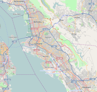
Temescal is one of the oldest neighborhoods in Oakland, California, located in North Oakland, and centered on Telegraph Avenue. The neighborhood derives its name from Temescal Creek, a significant watercourse in the city.

Temescal Creek is one of the principal watercourses in the city of Oakland, California, United States.
The Lorin district is a neighborhood located in the southern part of Berkeley, California, bounded by Ashby Avenue to the north, Adeline Street and Martin Luther King Jr. Way to the east, Sacramento Street to the west, and 62nd Street to the south.

Downtown Berkeley is the central business district of the city of Berkeley, California, United States, around the intersection of Shattuck Avenue and Center Street, and extending north to Hearst Avenue, south to Dwight Way, west to Martin Luther King Jr. Way, and east to Oxford Street. Downtown is the mass transit hub of Berkeley, with several AC Transit and UC Berkeley bus lines converging on the city's busiest BART station, as well as the location of Berkeley's civic center, high school, and Berkeley City College.

Oakland – Jack London Square is a train station in Jack London Square of Oakland, California, United States. The station is served by Amtrak's Capitol Corridor, Coast Starlight, and San Joaquins trains. Through Thruway buses, this station is one of two that serves San Francisco, the other being Emeryville.

The Oakland Public Library is the public library in Oakland, California. Opened in 1878, the Oakland Public Library currently serves the city of Oakland, along with neighboring smaller cities Emeryville and Piedmont. The Oakland Public Library has the largest collection of any public library in the East Bay, featuring approximately 1.5 million items. It consists of a main library located in downtown Oakland, and 16 branch libraries throughout the city.

Downtown Oakland is the central business district of Oakland, California, United States; roughly bounded by both the Oakland Estuary and Interstate 880 on the southwest, Interstate 980 on the northwest, Grand Avenue on the northeast, and Lake Merritt on the east.

North Oakland is an area in Oakland, California, United States, bordered by Downtown Oakland, Oakland Hills, and the adjacent cities of Berkeley, Emeryville and Piedmont. Annexed to Oakland in 1897. It is known as the birthplace of the Black Panther Party and is the childhood home of both the co-founders, which are Dr. Huey P. Newton and Bobby Seale. It is also the birthplace and childhood home of Sue Draheim, internationally recognized fiddler.
University High School was a public high school serving the northwestern portion of Oakland, California. It originally opened in 1923 at what was 5714 Grove Street. Due to the proximity of the campus to the City of Berkeley, "UNI" gained the reputation of the "feeder" high school of Oakland of students directly to the University of California. The high school was closed following World War II in 1948.
Ghost Town is the informal name of the Foster Hoover Historic District neighborhood in West Oakland, Oakland, California. The community is known for its violence and blight. Some people believe the name originates from a drug kingpin who referred to the area as a ghost town due to the shortage of other drug dealers whose absence was attributed to the kingpin's dominance over the area. Others believe it derives from the two former casket companies located side by side on Filbert Street between 30th and 32nd Streets. Ghost Town stretches from 27th Street to 35th Street in the area immediately southwest of the MacArthur Maze. Others see the neighborhood bounded by Adeline on the West and San Pablo on the East. Ghost Town Farms, one of the more successful expressions of urban agriculture activity in Oakland is located in the heart of the district at 2727 Martin Luther King Jr. Way, between 27th and 28th Streets. The area is also one of Oakland's many open-air art galleries, with exceptional muralist work continually on exhibition, particularly along Martin Luther King Jr. Way. This neighborhood has an active citizen crime patrol, including one group of seniors who walk the neighborhood weekly to get physical exercise and report blight. Jerry Brown, governor of California and former Mayor of Oakland stated: "Instead of an omnibus crime bill, you have to deal with shootings in Ghost Town in West Oakland and sideshows in East Oakland." Brown made attempts to turn around the blighted West Oakland neighborhood after 60 Minutes featured it in a television profile. Housing prices have increased. So has drug dealing, especially since nearby parks were closed by the City of Oakland. Prostitution, in 2015, has been on the decline for at least a decade.
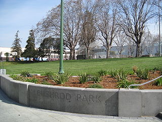
The Bushrod Park neighborhood in North Oakland, Oakland, California is an area surrounding its namesake park, and bounded by Martin Luther King, Jr. Way to the west, Claremont Avenue to the east, Highway 24 to the south, and the Berkeley border to the north. It borders the neighborhoods of Sante Fe to the west, Fairview Park to the east, and Temescal and Shafter to the south and southeast, respectively. Notable landmarks include the Bushrod Park ballfields and the former Bushrod Washington Elementary School, which share adjoining land on a large greenbelt and open space in the heart of the neighborhood.

Longfellow is a neighborhood of North Oakland, California. It is bounded by Temescal Creek to the north, State Route 24 to the east, Interstate 580 to the south, and Adeline Street to the west.
Broadway Heights is a small community in the southeastern section of the city of San Diego. It is bordered on the north, east, and west by Lemon Grove, and on the south by Encanto and Mallard Street. The predominantly African-American community has 629 residents and zero businesses within its seven blocks. Weston Street was renamed to Martin Luther King Jr. Way due to a youth campaign, marking the first time a street in San Diego was named after him.


