Tishomingo County is a county located in the northeastern corner of the U.S. state of Mississippi. As of the 2010 census, the population was 19,593. Its county seat is Iuka.

Iuka is a city in and the county seat of Tishomingo County, Mississippi, United States. Its population was 3,028 at the 2010 census. Woodall Mountain, the highest point in Mississippi, is located just south of Iuka.

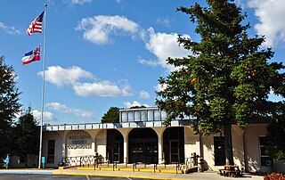
Tishomingo is a town in Tishomingo County, Mississippi, United States. The population of the city of Tishomingo was 339 at the 2010 census.

USS Tyler was originally a merchant ship named A. O. Tyler, a commercial side-wheel steamboat with twin stacks and covered paddles positioned aft. Constructed in Cincinnati, Ohio in 1857, it was acquired by the United States Navy, 5 June 1861 for service in the American Civil War and converted into the gunboat USS Tyler on 5 June 1861. She was commissioned in September 1861. She was protected with thick wooden bulwarks.

The third USS Lexington was a timberclad gunboat in the United States Navy during the American Civil War.
The first USS Undine was a "tinclad" steamer in the United States Navy in 1864, during the American Civil War. She was captured on 30 October and put in service with the Confederates, but was not renamed before being burned, 5 days later, to prevent re-capture.
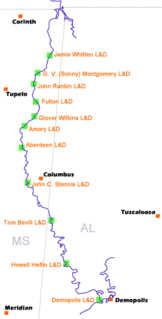
The Tennessee–Tombigbee Waterway is a 234-mile (377 km) man-made U.S. waterway built in the 20th century from the Tennessee River to the junction of the Black Warrior-Tombigbee River system near Demopolis, Alabama. The Tennessee–Tombigbee Waterway links commercial navigation from the nation's midsection to the Gulf of Mexico. The major features of the waterway are 234 miles (377 km) of navigation channels, a 175-foot-deep (53 m) cut between the watersheds of the Tombigbee and Tennessee rivers, and ten locks and dams. The locks are 9 by 110 by 600 feet, the same dimension as those on the Mississippi above Lock and Dam 26 at Alton, Illinois. Under construction for 12 years by the U.S. Army Corps of Engineers, the Tennessee–Tombigbee Waterway was completed in December 1984 at a total cost of nearly $2 billion.
Mississippi Highway 365 is a state highway in northeastern Mississippi. The route starts at MS 30 in Burton and travels northward. It travels into Burnsville and intersects U.S. Route 72. MS 365 continues northeastward and ends at MS 25 west of Pickwick Lake. The route was designated by 1950, connecting from MS 30 to MS 364. It was extended northward to MS 356 around 1958 and was completely paved by 1964. The route replaced parts of MS 356 in 1965, and its northern terminus was changed to MS 25.
Mississippi Highway 172 (MS 172) is a state highway located in Tishomingo County, Mississippi. The route runs 12.074 mi (19.431 km) from U.S. Route 72 (US 72) near Burnsville east to US 72 near Oldham, just west of the Alabama border. The route is a two-lane undivided road its entire length and runs mostly through wooded areas. It also passes through the town of Iuka, where it has an intersection with MS 25.

USS Peosta (1857) – also known as "Tinclad" # 36—was a steamboat acquired by the Union Navy during the American Civil War. Peosta was outfitted as an armed gunboat, with heavy guns for battles at sea, and large howitzers for shore bombardment. She served on the rivers and other waterways of the Confederate States of America enforcing the Union blockade on the South.

Pickwick Landing Dam is a hydroelectric dam on the Tennessee River in Hardin County, in the U.S. state of Tennessee. The dam is one of nine dams on the river owned and operated by the Tennessee Valley Authority, which built the dam in the 1930s as part of a New Deal-era initiative to create a continuous navigation channel between the river's mouth and Knoxville, and bring economic development to the area. The dam impounds the 43,100-acre (17,400 ha) Pickwick Lake and its tailwaters are part of Kentucky Lake.

The Memphis and Charleston Railroad, completed in 1857, was the first railroad in the United States to link the Atlantic Ocean with the Mississippi River. Chartered in 1846, the 311 miles (501 km) 5 ft gauge railroad ran from Memphis, Tennessee to Stevenson, Alabama through the towns of Corinth, Mississippi and Huntsville, Alabama. The portion between Memphis and LaGrange, Tennessee was originally to be part of the LaGrange and Memphis Railroad, chartered in 1838. From Stevenson, the road was connected to Chattanooga, Tennessee via the Nashville and Chattanooga Railroad. In Alabama, the railroad followed the route of the Tuscumbia, Courtland and Decatur Railroad between Tuscumbia and Decatur, the first railroad to be built west of the Appalachian Mountains.
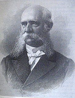
Seth Ledyard Phelps was an American naval officer, and in later life, a politician and diplomat. Phelps received his first commission in United States Navy as a midshipman aboard the famous USS Independence. He served patrolling the coast of West Africa guarding against slavers. During the Mexican–American War he served on gunboats, giving support to Winfield Scott's army, and later served in the Mediterranean and Caribbean squadrons.
State Route 57 is an east–west highway that runs from Memphis to the Mississippi state line near Pickwick Dam and Pickwick Landing State Park. Except for in Shelby County and western Fayette County, SR 57 is a two lane road generally with a 55 mph (89 km/h) speed limit. The majority of the road follows the path of the Memphis and Charleston Railroad.
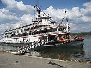
Steamboats played a major role in the 19th-century development of the Mississippi River and its tributaries by allowing the practical large-scale transport of passengers and freight both up- and down-river. Using steam power, riverboats were developed during that time which could navigate in shallow waters as well as upriver against strong currents. After the development of railroads, passenger traffic gradually switched to this faster form of transportation, but steamboats continued to serve Mississippi River commerce into the early 20th century. A small number of steamboats are used for tourist excursions into the 21st century.

Counce is an unincorporated community in Hardin County, Tennessee. Counce is located on Tennessee State Route 57 near the Mississippi border. The community is adjacent to the Tennessee River near the Pickwick Landing Dam. Counce is the terminus of a Kansas City Southern line which was originally the Corinth and Counce Railroad and later became part of the MidSouth Rail Corporation before Kansas City Southern took over MidSouth. Counce was named after the Counce families, who were the first families to inhabit the community.
Short is an unincorporated community in Tishomingo County, Mississippi, United States. It was one of the earliest settlements in the county, and once had its own post office, a high school, a bowling alley, and three bars; but most of its former territory and its establishments were drowned by the damming of the Tennessee River and the subsequent creation of Pickwick Lake.

Seventy-Six was an unincorporated community in Brazeau Township in eastern Perry County, Missouri, United States. It was located fourteen miles east of Perryville, ninety miles south of Saint Louis, and lay directly on the Mississippi River.

Danville is a ghost town in Alcorn County, Mississippi, United States.
Andrew Boyd Dilworth was an American farmer, politician, and military officer.


