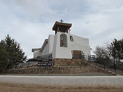
El Rancho, New Mexico | |
---|---|
Coordinates: 35°53′34″N106°05′08″W / 35.89278°N 106.08556°W | |
Country | United States |
State | New Mexico |
County | Santa Fe |
Area | |
• Total | 2.10 sq mi (5.44 km2) |
• Land | 2.10 sq mi (5.44 km2) |
• Water | 0.00 sq mi (0.00 km2) |
Elevation | 5,640 ft (1,720 m) |
Population | |
• Total | 1,120 |
• Density | 533.59/sq mi (206.02/km2) |
Time zone | UTC-7 (Mountain (MST)) |
• Summer (DST) | UTC-6 (MDT) |
Area code | 505 |
FIPS code | 35-23840 |
GNIS feature ID | 2408059 [2] |
El Rancho is a census-designated place (CDP) in Santa Fe County, New Mexico, United States. It is part of the Santa Fe, New Mexico Metropolitan Statistical Area. The population was 1,199 at the 2010 census. [4]
According to the United States Census Bureau, the CDP has a total area of 2.1 square miles (5.4 km2), all land. [4]
Census | Pop. | Note | %± |
---|---|---|---|
2020 | 1,120 | — | |
U.S. Decennial Census [5] [3] |
As of the census [6] of 2000, there were 817 people, 310 households, and 221 families residing in the CDP. The population density was 355.6 inhabitants per square mile (137.3/km2). There were 345 housing units at an average density of 150.2 per square mile (58.0/km2). The racial makeup of the CDP was 82.62% White, 1.47% Native American, 0.12% Pacific Islander, 10.53% from other races, and 5.26% from two or more races. Hispanic or Latino of any race were 70.26% of the population.
There were 310 households, out of which 39.4% had children under the age of 18 living with them, 56.1% were married couples living together, 10.6% had a female householder with no husband present, and 28.4% were non-families. 24.5% of all households were made up of individuals, and 5.2% had someone living alone who was 65 years of age or older. The average household size was 2.64 and the average family size was 3.16.
In the CDP, the population was spread out, with 27.8% under the age of 18, 7.3% from 18 to 24, 28.0% from 25 to 44, 25.6% from 45 to 64, and 11.3% who were 65 years of age or older. The median age was 37 years. For every 100 females, there were 92.7 males. For every 100 females age 18 and over, there were 89.7 males.
The median income for a household in the CDP was $31,450, and the median income for a family was $33,958. Males had a median income of $32,500 versus $23,864 for females. The per capita income for the CDP was $17,353. About 5.4% of families and 7.4% of the population were below the poverty line, including 8.1% of those under age 18 and 3.1% of those age 65 or over.
It is zoned to Pojoaque Valley Schools. [7] Pojoaque Valley High School is the zoned comprehensive high school.
Santa Fe County is a county located in the U.S. state of New Mexico. As of the 2020 census, the population was 154,823, making it New Mexico's third-most populous county, after Bernalillo County and Doña Ana County. Its county seat is Santa Fe, the state capital.
Sandoval County is a county located in the U.S. state of New Mexico. As of the 2020 census, the population was 148,834, making it the fourth-most populous county in New Mexico. The county seat is Bernalillo.
Rancho Santa Fe is a census-designated place (CDP) in San Diego County, California, United States, within the San Diego metropolitan area. The population was 3,156 at the 2020 census. The CDP is primarily residential with a few shopping blocks, a middle and elementary school, and several restaurants.
Cañada de los Alamos is a census-designated place (CDP) in Santa Fe County, New Mexico, United States. It is part of the Santa Fe, New Mexico Metropolitan Statistical Area. The population was 434 at the 2010 census.
Cedar Grove is a census-designated place (CDP) in Santa Fe County, New Mexico, United States. It is part of the Santa Fe, New Mexico Metropolitan Statistical Area. The population was 747 at the 2010 census. Cedar Grove was formerly a stage and freight stop. It has developed into a Santa Fe suburb. New Mexico "cedars" are abundant in the town.
Chupadero is a census-designated place (CDP) in Santa Fe County, New Mexico, United States. It is part of the Santa Fe, New Mexico Metropolitan Statistical Area. The population was 362 at the 2010 census.
Cuartelez is a census-designated place (CDP) in Santa Fe County, New Mexico, United States. It is part of the Santa Fe, New Mexico Metropolitan Statistical Area. The population was 469 at the 2010 census.
Cundiyo is a census-designated place (CDP) in Santa Fe County, New Mexico, United States. It is part of the Santa Fe, New Mexico Metropolitan Statistical Area. The population was 72 at the 2010 census. The name means round hill of the little bells in Tewa.
Cuyamungue is a census-designated place (CDP) in Santa Fe County, New Mexico, United States. It is part of the Santa Fe, New Mexico Metropolitan Statistical Area. The population was 479 at the 2010 census.
El Valle de Arroyo Seco is a census-designated place (CDP) in Santa Fe County, New Mexico, United States. It is part of the Santa Fe, New Mexico Metropolitan Statistical Area. The population was 1,440 at the 2010 census.
Galisteo is a census-designated place (CDP) in Santa Fe County, New Mexico, United States. It is part of the Santa Fe, New Mexico Metropolitan Statistical Area. The population was 253 at the 2010 census.
Glorieta is a census-designated place (CDP) in Santa Fe County, New Mexico, United States. It is part of the Albuquerque–Santa Fe–Las Vegas combined statistical area. The population was 430 at the 2010 census. The community is located in the southern Sangre de Cristo Mountains, along Interstate 25 on the east side of Glorieta Pass.
Jaconita is a census-designated place (CDP) in Santa Fe County, New Mexico, United States. It is part of the Santa Fe, New Mexico Metropolitan Statistical Area. The population was 332 at the 2010 census. It is considered to be a part of the Pojoaque Valley.
La Cienega is a census-designated place (CDP) in Santa Fe County, New Mexico, United States. It is part of the Santa Fe, New Mexico, metropolitan statistical area. The population was 3,007 at the 2000 census.
La Puebla is a census-designated place (CDP) in Santa Fe County, New Mexico, United States. It is part of the Santa Fe, New Mexico Metropolitan Statistical Area. The population was 1,296 at the 2000 census.
Pojoaque, Po’su wae geh, which translates to “water gathering place”, is a unincorporated community in Santa Fe County, New Mexico, United States. It is part of the Santa Fe, New Mexico Metropolitan Statistical Area. The population was 1,907 at the 2010 census. For statistical purposes, the United States Census Bureau has defined Pojoaque as a census-designated place (CDP). Pojoaque Pueblo, a neighboring community, is an Indian reservation, and the town of Pojoaque is a collection of communities near the pueblo with people from various ethnic backgrounds. The area of Pojoaque includes the neighborhoods of Cuyamungue, Jacona, Jaconita, Nambé and El Rancho.
Rio Chiquito is a census-designated place in Santa Fe County, New Mexico, United States. It is part of the Santa Fe, New Mexico Metropolitan Statistical Area. The population was 103 at the 2000 census.
Rio en Medio is a census-designated place (CDP) in Santa Fe County, New Mexico, United States. It is part of the Santa Fe, New Mexico Metropolitan Statistical Area. The population was 131 at the 2000 census.
Santa Cruz, historically known as Santa Cruz de la Cañada, is a census-designated place (CDP) in Santa Fe County, New Mexico, United States. It is part of the Santa Fe, New Mexico Metropolitan Statistical Area. The population was 423 at the 2000 census.
Sombrillo is a census-designated place (CDP) in Santa Fe County, New Mexico, United States. It is part of the Santa Fe, New Mexico Metropolitan Statistical Area. The population was 493 according to the 2000 census.
Media related to El Rancho, New Mexico at Wikimedia Commons