
Albert was a Legislative Assembly electorate in the state of Queensland which existed from 1887 to 1949 and 1959 to 2017.
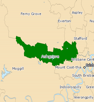
Ashgrove was a Legislative Assembly of Queensland electoral district in the state of Queensland, Australia from 1960 to 2017.

Brisbane Central was an electoral division in the state of Queensland, Australia.
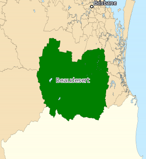
Beaudesert was an electoral district of the Legislative Assembly in the Australian state of Queensland from 1991 to 2017.

Kawana is an electoral district of the Legislative Assembly in the Australian state of Queensland. Based on the Sunshine Coast, the district has been held by both sides of politics over its short history.

Chatsworth is an electoral district of the Legislative Assembly in the Australian state of Queensland. The electorate is centred on the south-eastern suburbs of Brisbane and stretches north to Tingalpa, west to Carina Heights, east to Tingalpa Creek and south to Bulimba Creek.
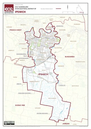
Ipswich is a Legislative Assembly of Queensland electoral district on the Brisbane River, west of Brisbane in the Australian state of Queensland. The electorate includes Ipswich and its suburbs, south and east of the Bremer River, west of Bundamba Creek and north of the Cunningham Highway.
Darling Downs was an electoral district of the Legislative Assembly in the Australian state of Queensland. It was named for the Darling Downs region.

Kurwongbah is an electoral district of the Legislative Assembly in the Australian state of Queensland which existed at first from 1992 to 2009, and was re-introduced for the 2017 state election. It is named after Lake Kurwongbah.The district is based in the Moreton Bay Region.
Fitzroy was an electoral district of the Legislative Assembly in the Australian state of Queensland.

Dalrymple was an electoral district of the Legislative Assembly in the Australian state of Queensland from 2009 to 2017.
Fortitude Valley, originally known as Hamlet of Fortitude Valley, was a Legislative Assembly electorate in the state of Queensland.
Eastern Downs was a Legislative Assembly electorate in the colony of Queensland.
Blackall was a Legislative Assembly electorate in the state of Queensland from 1873 to 1888.
The electoral district of Normanby was a Legislative Assembly electorate in the state of Queensland from 1872 until 1949.
Oxley was a Legislative Assembly electorate in the state of Queensland.
The electoral district of Ipswich East was a Legislative Assembly electorate in the state of Queensland. It was first created in a redistribution ahead of the 1960 state election, and existed until the 1972 state election.
The electoral district of Woothakata was a Legislative Assembly electorate in the state of Queensland. It was first created in a redistribution ahead of the 1888 colonial election, and existed until the 1912 state election.
The electoral district of Kelvin Grove was a Legislative Assembly electorate in the state of Queensland. It was first created in a redistribution ahead of the 1923 state election, and existed until the 1960 state election.
The electoral district of Marodian was a Legislative Assembly electorate in the state of Queensland. It was first created in a redistribution ahead of the 1950 state election, and existed until the 1960 state election.
