
The Division of Moreton is an Australian Electoral Division in Queensland.

Mount Ommaney is an electoral district of the Legislative Assembly in the Australian state of Queensland. It was created with the 1992 redistribution.

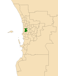
Churchlands is a Legislative Assembly electorate in the state of Western Australia. Churchlands is named for the western suburb of Churchlands which falls within its borders, and was created at the 1994 redistribution, replacing the seat of Floreat which had existed since 1968.
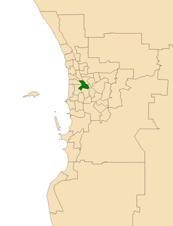
The Electoral district of Nedlands is a Legislative Assembly electorate in the state of Western Australia. Nedlands is named for the inner western Perth suburb of Nedlands which falls within its borders.
The Electoral district of Perth is a Legislative Assembly electorate in the state of Western Australia. Perth is named for the capital city of Western Australia whose central business district falls within its borders. It is one of the oldest electorates in Western Australia, with its first member having been elected in the inaugural 1890 elections of the Legislative Assembly.
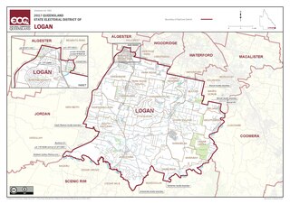
Logan is an electoral district in southern Queensland, Australia.

Townsville is an electoral district of the Legislative Assembly in the Australian state of Queensland. The seat is one of four within the Townsville urban area in North Queensland, and covers the Eastern and Northern suburbs of the City of Townsville as well as Magnetic Island and Palm Island.
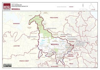
Moggill is an electoral district in the Legislative Assembly of Queensland in the state of Queensland, Australia. The electorate is held by Dr Christian Rowan, for the Liberal National Party of Queensland.
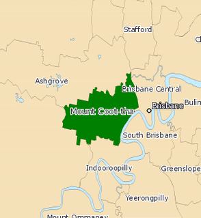
Mount Coot-tha was an electoral district in the Legislative Assembly of Queensland in the state of Queensland, Australia from 1950 to 2017.

Yeerongpilly is a southern suburb in the City of Brisbane, Queensland, Australia. In the 2016 census, Yeerongpilly had a population of 1,934 people.
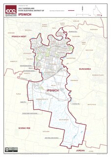
Ipswich is a Legislative Assembly of Queensland electoral district on the Brisbane River, west of Brisbane in the Australian state of Queensland. The electorate includes Ipswich and its suburbs, south and east of the Bremer River, west of Bundamba Creek and north of the Cunningham Highway.

Stafford is a Legislative Assembly of Queensland electoral district in the state of Queensland, Australia.

Indooroopilly was an electoral district of the Legislative Assembly in the Australian state of Queensland from 1992 to 2017.

Lytton is an electoral district of the Legislative Assembly in the Australian state of Queensland.
Kurilpa was a Legislative Assembly electorate in the state of Queensland from 1912 to 1986. It was named for the Kurilpa Peninsula on the Brisbane River. Until 1960, it was based in the inner southern Brisbane suburbs of West End and the western parts of South Brisbane, but after that, also included Dutton Park, Fairfield, Highgate Hill and parts of Yeronga and Annerley.
Mount Gravatt was an electoral district of the Legislative Assembly in the Australian state of Queensland from 1950 to 2009.
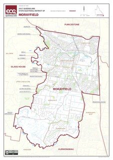
Morayfield is an electoral district of the Legislative Assembly in the Australian state of Queensland. It is located in the northern outskirts of Brisbane, south of the Sunshine Coast.
The Shire of Stephens was a local government area in the inner southern suburbs of Brisbane, Queensland, Australia. The shire, administered from Annerley, covered an area of 9 square miles (23 km2), and existed as a local government entity from 1886 until 1925, when it was amalgamated into the City of Brisbane under the City of Brisbane Act 1924.

The City of Brisbane is a local government area (LGA) which comprises the inner portion of the metropolitan area of Brisbane, the capital of Queensland, Australia. Its governing body is the Brisbane City Council. Unlike LGAs in the other mainland state capitals, which are generally responsible only for the central business districts and inner neighbourhoods of those cities, the City of Brisbane administers a significant portion of the Brisbane metropolitan area, serving almost half of the population of the Brisbane Greater Capital City Statistical Area (GCCSA). As such, it has a larger population than any other local government area in Australia. The City of Brisbane was the first Australian LGA to reach a population of more than one million. Its population is roughly equivalent to the populations of Tasmania, the Australian Capital Territory and the Northern Territory combined. In 2016–2017, the council administered a budget of over $3 billion, by far the largest budget of any LGA in Australia.
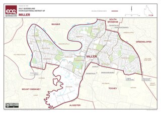
Miller is an electoral district of the Legislative Assembly in the Australian state of Queensland. It was created in the 2017 redistribution. It was named after Emma Miller, a labour and suffrage activist.
